


The Maine Geological Survey provides the people and businesses of Maine with essential geologic information about the land where we live and work.
Note: Many state documents are offered in PDF format. To view PDF documents, you will need the free Adobe Reader. If you need assistance, view our Maine government PDF Help page or contact the contributing Maine State agency via the link on the left sidebar under “Links”.
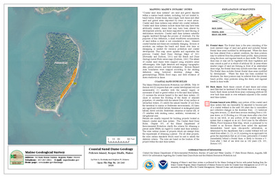
-

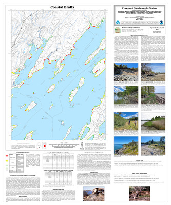
Coastal bluffs in the Freeport quadrangle, Maine
Marita Bryant, Walter A. Barnhardt, Stephen M. Dickson, and Joseph T. Kelley
Maine Geological Survey, Open-File Map 02-188 (Superseded by Bryant, Barnhardt, Dickson, and Kelley, 2019, Maine Geological Survey Open-File 19-5)
-

Coastal bluffs in the Friendship quadrangle, Maine
David A. Sinson, Thomas D. Henze, Julia F. Daly, Stephen M. Dickson, and Joseph T. Kelley
Maine Geological Survey, Open-File Map 02-189
-

Coastal bluffs in the Hampden quadrangle, Maine
Stephen M. Dickson
Maine Geological Survey, Open-File Map 02-190
-

Coastal bluffs in the Hewett Island quadrangle, Maine
David A. Sinson, Julia F. Daly, Stephen M. Dickson, and Joseph T. Kelley
Maine Geological Survey, Open-File Map 02-191
-

Coastal bluffs in the Kittery quadrangle, Maine
Allison L. Brandes, Earle G. Hildreth III, Stephen M. Dickson, and Joseph T. Kelley
Maine Geological Survey, Open-File Map 02-193
-

Coastal bluffs in the Lincolnville quadrangle, Maine
Marita Bryant, Walter A. Barnhardt, Stephen M. Dickson, and Joseph T. Kelley
Maine Geological Survey, Open-File Map 02-194
-

Coastal bluffs in the Louds Island quadrangle, Maine
Allison L. Brandes, David A. Sinson, Rebecca A. Nestor, Earle G. Hildreth III, Julia F. Daly, Stephen M. Dickson, and Joseph T. Kelley
Maine Geological Survey, Open-File Map 02-195
-

Coastal bluffs in the Monhegan quadrangle, Maine
Julia F. Daly, Stephen M. Dickson, and Joseph T. Kelley
Maine Geological Survey, Open-File Map 02-196
-

Coastal bluffs in the Newbury Neck quadrangle, Maine
Jessica L. Black, Ben C. Johnston, Rebecca A. Nestor, Corinn C. Keblinsky, Jennifer L. Hall, Stephen M. Dickson, and Joseph T. Kelley
Maine Geological Survey, Open-File Map 02-198
-

Coastal bluffs in the New Harbor quadrangle, Maine
David A. Stinson, Allison L. Brandes, Julia F. Daly, Stephen M. Dickson, and Joseph T. Kelley
Maine Geological Survey, Open-File Map 02-197
-

Coastal bluffs in the Old Orchard Beach quadrangle, Maine
David A. Sinson, Rebecca A. Nestor, Stephen M. Dickson, and Joseph T. Kelley
Maine Geological Survey, Open-File Map 02-199
-

Coastal bluffs in the Orland quadrangle, Maine
Walter A. Barnhardt, Stephen M. Dickson, and Joseph T. Kelley
Maine Geological Survey, Open-File Map 02-200
-

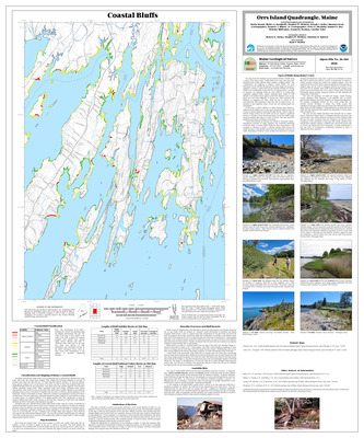
Coastal bluffs in the Orrs Island quadrangle, Maine
Marita Bryant, Walter A. Barnhardt, Stephen M. Dickson, and Joseph T. Kelley
Maine Geological Survey, Open-File Map 02-201 (Superseded by Bryant, et. al., 2020, Maine Geological Survey Open-File 20-18)
-

Coastal bluffs in the Penobscot quadrangle, Maine
Walter A. Barnhardt, Stephen M. Dickson, and Joseph T. Kelley
Maine Geological Survey, Open-File Map 02-203
-

Coastal bluffs in the Phippsburg quadrangle, Maine
Allison L. Brandes, David A. Sinson, Rebecca A. Nestor, Earle G. Hildreth III, Marita Bryant, Walter A. Barnhardt, Stephen M. Dickson, and Joseph T. Kelley
Maine Geological Survey, Open-File Map 02-204 (Superseded by Brandes et. al., 2026, Maine Geological Survey Open-File 26-268)
-

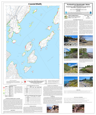
Coastal bluffs in the Portland East quadrangle, Maine
Marita Bryant, Walter A. Barnhardt, Stephen M. Dickson, and Joseph T. Kelley
Maine Geological Survey, Open-File Map 02-205 (Superseded by Bryant, et. al., 2020, Maine Geological Survey Open-File 20-15)
-

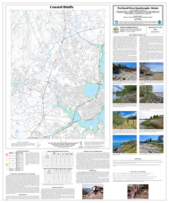
Coastal bluffs in the Portland West quadrangle, Maine
Marita Bryant, Walter A. Barnhardt, Stephen M. Dickson, and Joseph T. Kelley
Maine Geological Survey, Open-File Map 02-206 (Superseded by Bryant et. al., 2026, Maine Geological Survey Open-File 26-270)
-

Coastal bluffs in the Portsmouth quadrangle, Maine
Allison L. Brandes, Stephen M. Dickson, and Josepth T. Kelley
Maine Geological Survey, Open-File Map 02-207
-

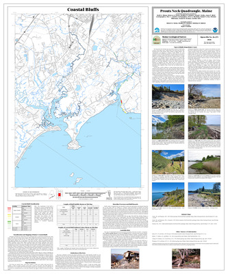
Coastal bluffs in the Prouts Neck quadrangle, Maine
David A. Sinson, Rebecca A. Nestor, Stephen M. Dickson, and Joseph T. Kelley
Maine Geological Survey, Open-File Map 02-208 (Superseded by Sinson et. al., 2026, Maine Geological Survey Open-File 26-271)
-

Coastal bluffs in the Rockland quadrangle, Maine
Julia F. Daley, David A. Sinson, Marita Bryant, Walter A. Barnhardt, Stephen M. Dickson, and Joseph T. Kelley
Maine Geological Survey, Open-File Map 02-209
-

Coastal bluffs in the Salsbury Cove quadrangle, Maine
Corinn C. Keblinsky, Kristie A. Ferland, Jennifer L. Hall, Rebecca A. Nestor, Ben C. Johnston, Stephen M. Dickson, and Joseph T. Kelley
Maine Geological Survey, Open-File Map 02-210
-

Coastal bluffs in the Sargentville quadrangle, Maine
Corinn C. Keblinsky, Nathan C. Gardner, Kristie A. Ferland, Walter A. Barnhardt, Stephen M. Dickson, and Joseph T. Kelley
Maine Geological Survey, Open-File Map 02-211
-

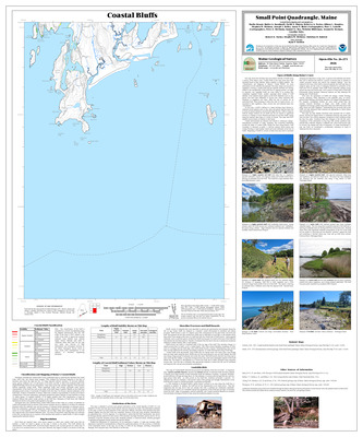
Coastal bluffs in the Small Point quadrangle, Maine
Marita Bryant, Walter A. Barnhardt, David A. Sinson, Rebecca A. Nestor, Allison L. Brandes, Stephen M. Dickson, and Joseph T. Kelley
Maine Geological Survey, Open-File Map 02-213 (Superseded by Bryant, et. al., 2026, Maine Geological Survey Open-File 26-273)
-

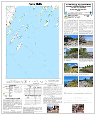
Coastal bluffs in the South Harpswell quadrangle, Maine
Marita Bryant, Walter A. Barnhardt, Stephen M. Dickson, and Joseph T. Kelley
Maine Geological Survey, Open-File Map 02-214 (Superseded by Bryant, et. al., 2020, Maine Geological Survey Open-File 20-16)
-

Coastal bluffs in the Stinson Neck quadrangle, Maine
Walter A. Barnhardt, Ben C. Johnston, Rebecca A. Nestor, Stephen M. Dickson, and Joseph T. Kelley
Maine Geological Survey, Open-File Map 02-215
-

Coastal bluffs in the Tenants Harbor quadrangle, Maine
David A. Sinson, Julia F. Daly, Stephen M. Dickson, and Joseph T. Kelley
Maine Geological Survey, Open-File Map 02-217
-

Coastal bluffs in the Thomaston quadrangle, Maine
Thomas D. Henze, David A. Sinson, Julia F. Daly, Stephen M. Dickson, and Joseph T. Kelley
Maine Geological Survey, Open-File Map 02-218
-

Coastal bluffs in the Waldoboro East quadrangle, Maine
David A. Sinson, Rebecca A. Nestor, Allison L. Brandes, Julia F. Daly, Stephen M. Dickson, and Joseph T. Kelley
Maine Geological Survey, Open-File Map 02-219
-

Coastal bluffs in the Waldoboro West quadrangle, Maine
David A. Sinson, Rebecca A. Nestor, Allison L. Brandes, Stephen M. Dickson, and Joseph T. Kelley
Maine Geological Survey, Open-File Map 02-220
-

Coastal bluffs in the Westport quadrangle, Maine
Thomas D. Henze, Douglas G. Hodum, David A. Sinson, Rebecca A. Nestor, Allison L. Brandes, Stephen M. Dickson, and Joseph T. Kelley
Maine Geological Survey, Open-File Map 02-221
-

Coastal bluffs in the Wiscasset quadrangle, Maine
Corinn C. Keblinsky, Nathan C. Gardiner, Thomas D. Henze, Douglas G. Hodum, Stephen M. Dickson, and Joseph T. Kelley
Maine Geological Survey, Open-File Map 02-222
-

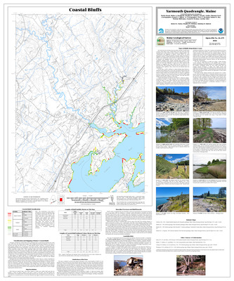
Coastal bluffs in the Yarmouth quadrangle, Maine
Marita Bryant, Walter A. Barnhardt, Stephen M. Dickson, and Joseph T. Kelley
Maine Geological Survey, Open-File Map 02-223
-

Coastal bluffs in the York Harbor quadrangle, Maine
Allison L. Brandes, Earle G. Hildreth III, Stephen M. Dickson, and Joseph T. Kelley
Maine Geological Survey, Open-File Map 02-224
-

Coastal bluffs of the Boothbay Harbor quadrangle, Maine
Allison L. Brandes, David A. Sinson, Rebecca A. Nestor, Earle G. Hildreth III, Thomas D. Henze, Douglas G. Hodum, Stephen M. Dickson, and Joseph T. Kelley
Maine Geological Survey, Open-File Map 02-176
-

Significant sand and gravel aquifers in the Ashland quadrangle, Maine
Craig D. Neil and Daniel B. Locke
Maine Geological Survey, Open-File Map 02-104
-

Significant sand and gravel aquifers in the Big Moose Pond quadrangle, Maine
Craig D. Neil and Daniel B. Locke
Maine Geological Survey, Open-File Map 02-225
-

Significant sand and gravel aquifers in the Bridgewater quadrangle, Maine
Craig D. Neil and Craig D. Neil
Maine Geological Survey, Open-File Map 02-118
-

Significant sand and gravel aquifers in the Caribou quadrangle, Maine
Craig D. Neil and Craig D. Neil
Maine Geological Survey, Open-File Map 02-125
-

Significant sand and gravel aquifers in the Daigle quadrangle, Maine
Craig D. Neil and Thomas K. Weddle
Maine Geological Survey, Open-File Map 02-138
-

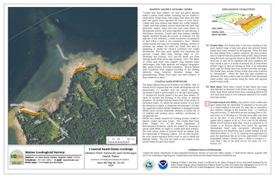
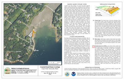
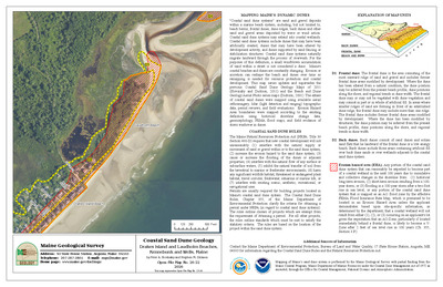
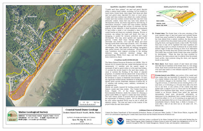
Significant sand and gravel aquifers in the Doyle Ridge quadrangle, Maine
Craig D. Neil and Michael E. Foley
Maine Geological Survey, Open-File Map 02-120
-

Significant sand and gravel aquifers in the Easton Center quadrangle, Maine
Craig D. Neil and Craig D. Neil
Maine Geological Survey, Open-File Map 02-113
-

Significant sand and gravel aquifers in the Easton quadrangle, Maine
Craig D. Neil and Craig D. Neil
Maine Geological Survey, Open-File Map 02-112
-

Significant sand and gravel aquifers in the Echo Lake quadrangle, Maine
Craig D. Neil and Craig D. Neil
Maine Geological Survey, Open-File Map 02-114
-

Significant sand and gravel aquifers in the Fort Fairfield NW quadrangle, Maine
Craig D. Neil and Michael E. Foley
Maine Geological Survey, Open-File Map 02-123
-

Significant sand and gravel aquifers in the Fort Fairfield quadrangle, Maine
Craig D. Neil and Craig D. Neil
Maine Geological Survey, Open-File Map 02-127
-

Significant sand and gravel aquifers in the Fort Kent North quadrangle, Maine
Craig D. Neil and Thomas K. Weddle
Maine Geological Survey, Open-File Map 02-131
-

Significant sand and gravel aquifers in the Fort Kent South quadrangle, Maine
Craig D. Neil and Thomas K. Weddle
Maine Geological Survey, Open-File Map 02-134
-

Significant sand and gravel aquifers in the Freeport quadrangle, Maine
Craig D. Neil and Daniel B. Locke
Maine Geological Survey, Open-File Map 02-155
-

Significant sand and gravel aquifers in the Frenchville quadrangle, Maine
Craig D. Neil and Thomas K. Weddle
Maine Geological Survey, Open-File Map 02-135
-

Significant sand and gravel aquifers in the Goodwin quadrangle, Maine
Craig D. Neil and Craig D. Neil
Maine Geological Survey, Open-File Map 02-126
-

Significant sand and gravel aquifers in the Grand Isle quadrangle, Maine
Craig D. Neil and Thomas K. Weddle
Maine Geological Survey, Open-File Map 02-137
-

Significant sand and gravel aquifers in the Griswold quadrangle, Maine
Craig D. Neil and Daniel B. Locke
Maine Geological Survey, Open-File Map 02-110
-

Significant sand and gravel aquifers in the Hadley Lake quadrangle, Maine
Craig D. Neil and Daniel B. Locke
Maine Geological Survey, Open-File Map 02-157
-

Significant sand and gravel aquifers in the Hamlin quadrangle, Maine
Craig D. Neil and Michael E. Foley
Maine Geological Survey, Open-File Map 02-121
-

Significant sand and gravel aquifers in the Lagrange quadrangle, Maine
Lauren E. Foster, Troy T. Smith, and Dale F. Doughty
Maine Geological Survey, Open-File Map 02-163
-

Significant sand and gravel aquifers in the Lake Auburn East quadrangle, Maine
Craig D. Neil and Daniel B. Locke
Maine Geological Survey, Open-File Map 02-149
-

Significant sand and gravel aquifers in the Lille quadrangle, Maine
Craig D. Neil and Thomas K. Weddle
Maine Geological Survey, Open-File Map 02-128
-

Significant sand and gravel aquifers in the Limestone quadrangle, Maine
Craig D. Neil and Michael E. Foley
Maine Geological Survey, Open-File Map 02-124
-

Significant sand and gravel aquifers in the Madawaska quadrangle, Maine
Craig D. Neil and Thomas K. Weddle
Maine Geological Survey, Open-File Map 02-136
-

Significant sand and gravel aquifers in the Mapleton quadrangle, Maine
Craig D. Neil and Daniel B. Locke
Maine Geological Survey, Open-File Map 02-106
-

Significant sand and gravel aquifers in the New Sweden quadrangle, Maine
Craig D. Neil and Michael E. Foley
Maine Geological Survey, Open-File Map 02-122
-

Significant sand and gravel aquifers in the Number Nine Lake quadrangle, Maine
Craig D. Neil and Craig D. Neil
Maine Geological Survey, Open-File Map 02-116
-

Significant sand and gravel aquifers in the Oxbow East quadrangle, Maine
Craig D. Neil and Daniel B. Locke
Maine Geological Survey, Open-File Map 02-109
-

Significant sand and gravel aquifers in the Packard Lake quadrangle, Maine
Craig D. Neil and Craig D. Neil
Maine Geological Survey, Open-File Map 02-117
-

Significant sand and gravel aquifers in the Paulette Brook quadrangle, Maine
Craig D. Neil and Thomas K. Weddle
Maine Geological Survey, Open-File Map 02-140
-

Significant sand and gravel aquifers in the Picard Brook quadrangle, Maine
Craig D. Neil and Michael E. Foley
Maine Geological Survey, Open-File Map 02-119
-

Significant sand and gravel aquifers in the Portage Lake East quadrangle, Maine
Craig D. Neil and Daniel B. Locke
Maine Geological Survey, Open-File Map 02-142
-

Significant sand and gravel aquifers in the Presque Isle quadrangle, Maine
Craig D. Neil and Craig D. Neil
Maine Geological Survey, Open-File Map 02-111
-

Significant sand and gravel aquifers in the Speckled Mountain quadrangle, Maine
Craig D. Neil and Daniel B. Locke
Maine Geological Survey, Open-File Map 02-147
-

Significant sand and gravel aquifers in the St. Agatha quadrangle, Maine
Craig D. Neil and Thomas K. Weddle
Maine Geological Survey, Open-File Map 02-139
-

Significant sand and gravel aquifers in the St. John quadrangle, Maine
Craig D. Neil and Thomas K. Weddle
Maine Geological Survey, Open-File Map 02-132
-

Significant sand and gravel aquifers in the Van Buren quadrangle, Maine
Craig D. Neil and Thomas K. Weddle
Maine Geological Survey, Open-File Map 02-130
-

Significant sand and gravel aquifers in the Violette Stream quadrangle, Maine
Craig D. Neil and Thomas K. Weddle
Maine Geological Survey, Open-File Map 02-129
-

Significant sand and gravel aquifers in the Washburn quadrangle, Maine
Craig D. Neil and Daniel B. Locke
Maine Geological Survey, Open-File Map 02-143
-

Significant sand and gravel aquifers in the Westfield quadrangle, Maine
Craig D. Neil and Craig D. Neil
Maine Geological Survey, Open-File Map 02-115
-

Significant sand and gravel aquifers in the Wheelock quadrangle, Maine
Craig D. Neil and Thomas K. Weddle
Maine Geological Survey, Open-File Map 02-133
-

Significant sand and gravel aquifers in the York Ridge quadrangle, Maine
Craig D. Neil and Daniel B. Locke
Maine Geological Survey, Open-File Map 02-105
-

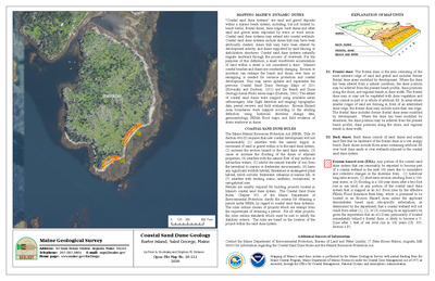
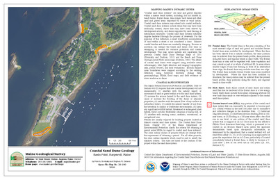
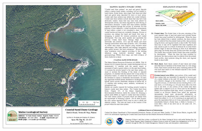
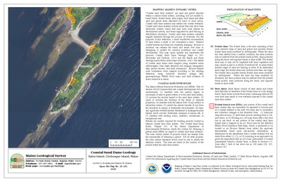
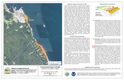
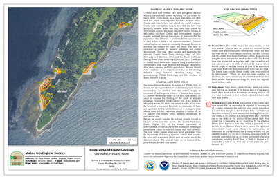
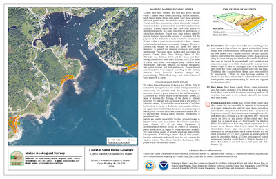
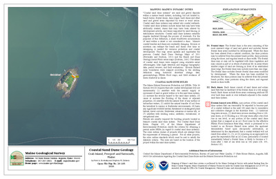
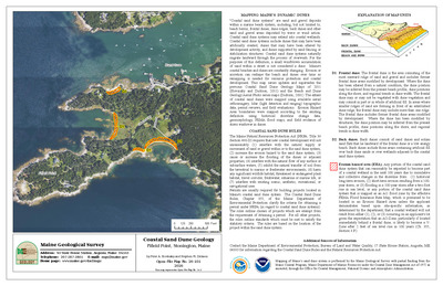
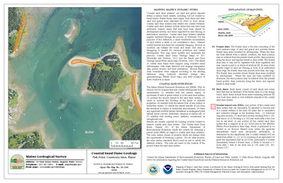
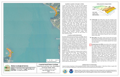
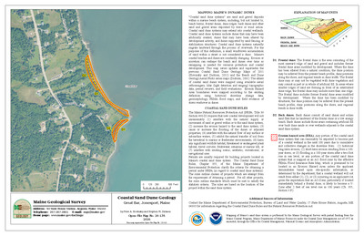
Simplified bedrock geologic map of Maine
Marc Loiselle
Maine Geological Survey, Open-File Map SBGMM. Map showing the simplified bedrock geology of Maine. Inset maps show regional metamorphic zones and generalized Northern Appalachian geology. The map also includes a generalized geologic cross section. A table and text on the reverse describe the geologic history of Maine and how it relates to plate tectonics.
-

Surficial geology of the Bath quadrangle, Maine
Thomas K. Weddle
Maine Geological Survey, Open-File Map 02-145
-

Surficial geology of the Lewiston quadrangle, Maine
Carol T. Hildreth
Maine Geological Survey, Open-File Map 02-154
-

Surficial geology of the Minot quadrangle, Maine
Carol T. Hildreth
Maine Geological Survey, Open-File Map 02-231
-

Surficial geology of the Speckled Mountain quadrangle, Maine
Woodrow B. Thompson
Maine Geological Survey, Open-File Map 02-144
-

Surficial materials of the Ashland quadrangle, Maine
Daniel B. Locke
Maine Geological Survey, Open-File Map 02-53
-

Surficial materials of the Bath quadrangle, Maine
Daniel B. Locke and Thomas K. Weddle
Maine Geological Survey, Open-File Map 02-102
-

Surficial materials of the Big Moose Pond quadrangle, Maine
Daniel B. Locke
Maine Geological Survey, Open-File Map 02-226
-

Surficial materials of the Bridgewater quadrangle, Maine
Craig D. Neil
Maine Geological Survey, Open-File Map 02-70
-

Surficial materials of the Bull Brook quadrangle, Maine
Daniel B. Locke
Maine Geological Survey, Open-File Map 02-87
-

Surficial materials of the Caribou quadrangle, Maine
Craig D. Neil
Maine Geological Survey, Open-File Map 02-77
-

Surficial materials of the Daigle quadrangle, Maine
Thomas K. Weddle
Maine Geological Survey, Open-File Map 02-99
-

Surficial materials of the Doyle Ridge quadrangle, Maine
Michael E. Foley
Maine Geological Survey, Open-File Map 02-72
-

Surficial materials of the Easton Center quadrangle, Maine
Craig D. Neil
Maine Geological Survey, Open-File Map 02-64
-

Surficial materials of the Easton quadrangle, Maine
Craig D. Neil
Maine Geological Survey, Open-File Map 02-63
-

Surficial materials of the Echo Lake quadrangle, Maine
Craig D. Neil
Maine Geological Survey, Open-File Map 02-65
-

Surficial materials of the Fort Fairfield NW quadrangle, Maine
Michael E. Foley
Maine Geological Survey, Open-File Map 02-75
-

Surficial materials of the Fort Fairfield quadrangle, Maine
Craig D. Neil
Maine Geological Survey, Open-File Map 02-79
-

Surficial materials of the Fort Kent North quadrangle, Maine
Thomas K. Weddle
Maine Geological Survey, Open-File Map 02-92
-

Surficial materials of the Fort Kent South quadrangle, Maine
Thomas K. Weddle
Maine Geological Survey, Open-File Map 02-95
-

Surficial materials of the Freeport quadrangle, Maine
Thomas K. Weddle
Maine Geological Survey, Open-File Map 02-156
-

Surficial materials of the Frenchville quadrangle, Maine
Thomas K. Weddle
Maine Geological Survey, Open-File Map 02-96
-

Surficial materials of the Goodwin quadrangle, Maine
Craig D. Neil
Maine Geological Survey, Open-File Map 02-78
-

Surficial materials of the Grand Isle quadrangle, Maine
Thomas K. Weddle
Maine Geological Survey, Open-File Map 02-98
-

Surficial materials of the Griswold quadrangle, Maine
Daniel B. Locke
Maine Geological Survey, Open-File Map 02-60
-

Surficial materials of the Hadley Lake quadrangle, Maine
Daniel B. Locke
Maine Geological Survey, Open-File Map 02-158
-

Surficial materials of the Hamlin quadrangle, Maine
Michael E. Foley
Maine Geological Survey, Open-File Map 02-73
-

Surficial materials of the Hanford quadrangle, Maine
Michael E. Foley
Maine Geological Survey, Open-File Map 02-84
-

Surficial materials of the Lake Auburn East quadrangle, Maine
Daniel B. Locke and Carol T. Hildreth
Maine Geological Survey, Open-File Map 02-150
-

Surficial materials of the Lewiston quadrangle, Maine
Carol T. Hildreth and Daniel B. Locke
Maine Geological Survey, Open-File Map 02-153
-

Surficial materials of the Lille quadrangle, Maine
Thomas K. Weddle
Maine Geological Survey, Open-File Map 02-89
-

Surficial materials of the Limestone quadrangle, Maine
Michael E. Foley
Maine Geological Survey, Open-File Map 02-76
-

Surficial materials of the Madawaska quadrangle, Maine
Thomas K. Weddle
Maine Geological Survey, Open-File Map 02-97
-

Surficial materials of the Mapleton quadrangle, Maine
Daniel B. Locke
Maine Geological Survey, Open-File Map 02-55
-

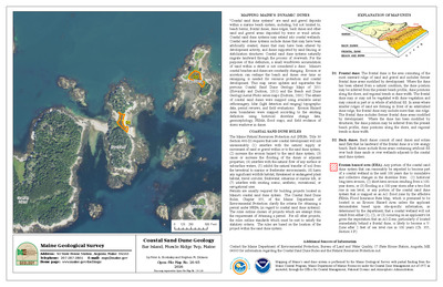
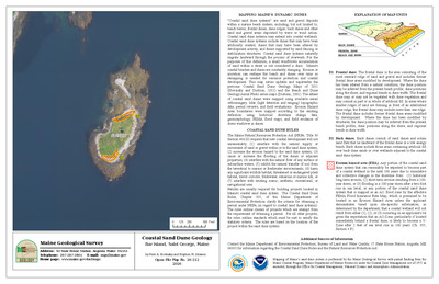
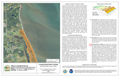
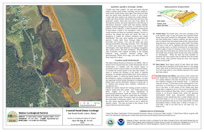
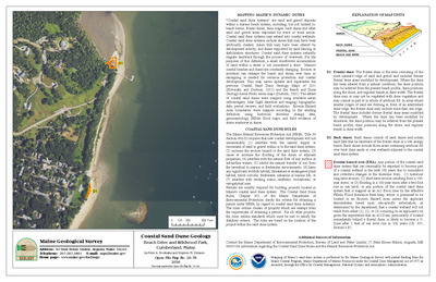
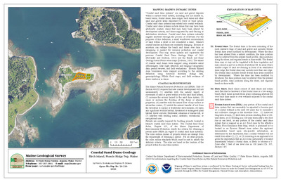
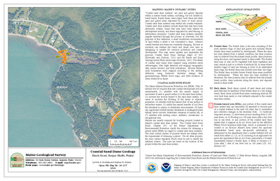
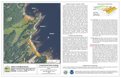
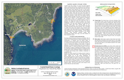
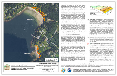
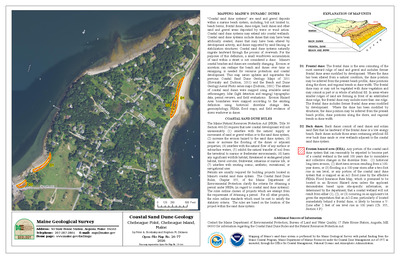
Surficial materials of the Mars Hill quadrangle, Maine
Craig D. Neil
Maine Geological Survey, Open-File Map 02-67
-

Surficial materials of the McClusky Lake quadrangle, Maine
Michael E. Foley
Maine Geological Survey, Open-File Map 02-83
-

Surficial materials of the Monmouth quadrangle, Maine
Daniel B. Locke and Mickael E. Foley
Maine Geological Survey, Open-File Map 02-160
-

Surficial materials of the Mud Lake quadrangle, Maine
Michael E. Foley
Maine Geological Survey, Open-File Map 02-85
-

Surficial materials of the New Sweden quadrangle, Maine
Michael E. Foley
Maine Geological Survey, Open-File Map 02-74
-

Surficial materials of the Number Nine Lake quadrangle, Maine
Craig D. Neil
Maine Geological Survey, Open-File Map 02-68
-

Surficial materials of the Old Orchard Beach quadrangle, Maine
Michael J. Retelle
Maine Geological Survey, Open-File Map 02-227
-

Surficial materials of the Oxbow East quadrangle, Maine
Daniel B. Locke
Maine Geological Survey, Open-File Map 02-59
-

Surficial materials of the Packard Lake quadrangle, Maine
Craig D. Neil
Maine Geological Survey, Open-File Map 02-69
-

Surficial materials of the Paulette Brook quadrangle, Maine
Thomas K. Weddle
Maine Geological Survey, Open-File Map 02-101
-

Surficial materials of the Picard Brook quadrangle, Maine
Michael E. Foley
Maine Geological Survey, Open-File Map 02-71
-

Surficial materials of the Portage Lake East quadrangle, Maine
Daniel B. Locke
Maine Geological Survey, Open-File Map 02-86
-

Surficial materials of the Presque Isle quadrangle, Maine
Craig D. Neil
Maine Geological Survey, Open-File Map 02-62
-

Surficial materials of the Speckled Mountain quadrangle, Maine
Woodrow B. Thompson
Maine Geological Survey, Open-File Map 02-103
-

Surficial materials of the Spinney Brook quadrangle, Maine
Daniel B. Locke
Maine Geological Survey, Open-File Map 02-61
-

Surficial materials of the Square Lake East quadrangle, Maine
Michael E. Foley
Maine Geological Survey, Open-File Map 02-81
-

Surficial materials of the Square Lake West quadrangle, Maine
Michael E. Foley
Maine Geological Survey, Open-File Map 02-80
-

Surficial materials of the St. Agatha quadrangle, Maine
Thomas K. Weddle
Maine Geological Survey, Open-File Map 02-100
-

Surficial materials of the St. John quadrangle, Maine
Thomas K. Weddle
Maine Geological Survey, Open-File Map 02-93
-

Surficial materials of the Stockholm quadrangle, Maine
Michael E. Foley
Maine Geological Survey, Open-File Map 02-82
-

Surficial materials of the Van Buren quadrangle, Maine
Thomas K. Weddle
Maine Geological Survey, Open-File Map 02-91
-

Surficial materials of the Violette Stream quadrangle, Maine
Thomas K. Weddle
Maine Geological Survey, Open-File Map 02-90
-

Surficial materials of the Washburn quadrangle, Maine
Daniel B. Locke
Maine Geological Survey, Open-File Map 02-88
-

Surficial materials of the Westfield quadrangle, Maine
Craig D. Neil
Maine Geological Survey, Open-File Map 02-66
-

Surficial materials of the Wheelock quadrangle, Maine
Thomas K. Weddle
Maine Geological Survey, Open-File Map 02-94
-

Surficial materials of the York Ridge quadrangle, Maine
Daniel B. Locke
Maine Geological Survey, Open-File Map 02-54
-

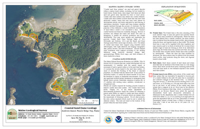
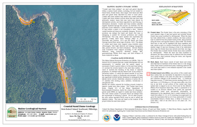
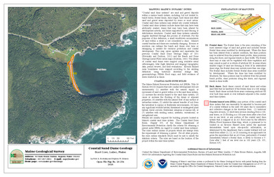
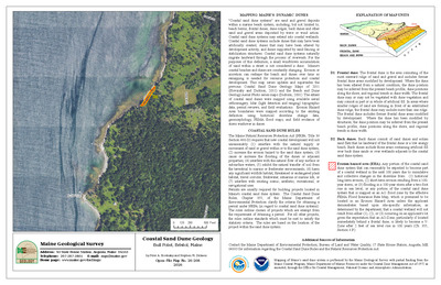
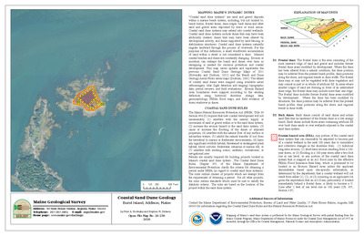
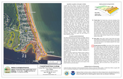
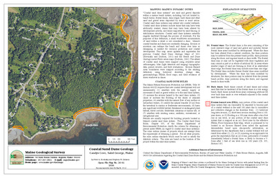
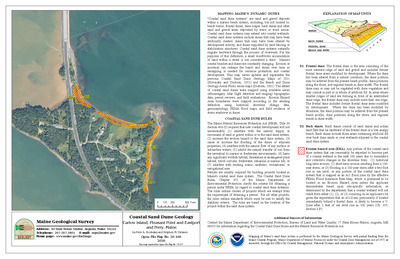
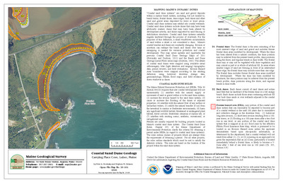
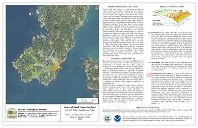
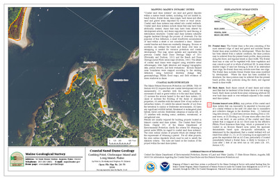
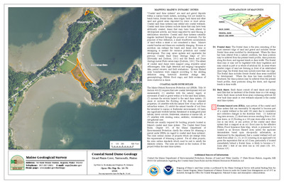
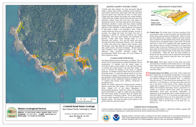
Beach and Dune Geology Aerial Photo: Camp Ellis, Saco Beach, Saco
Stephen M. Dickson
Maine Geological Survey, Open-File Map 01-398 (Superseded by Slovinsky and Dickson, 2011, Maine Geological Survey Open-File Map 11-108)
-

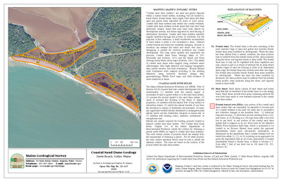
Beach and Dune Geology Aerial Photo: Coast Guard Beach, River Beach, Hunnewell Beach, Phippsburg
Stephen M. Dickson
Maine Geological Survey, Open-File Map 01-457 (Superseded by Slovinsky and Dickson, 2011, Maine Geological Survey, Open-file Map 11-142)
-

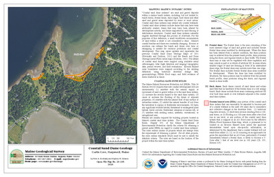
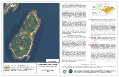
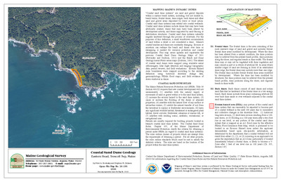
Beach and Dune Geology Aerial Photo: Crescent Beach, Cape Elizabeth
Stephen M. Dickson
Maine Geological Survey, Open-File Map 01-407 (Superseded by Slovinsky and Dickson, 2011, Maine Geological Survey, Open-file Map 11-130
-

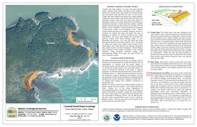
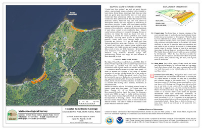
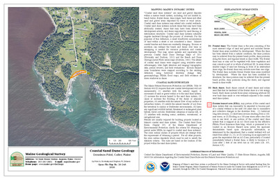
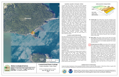
Beach and Dune Geology Aerial Photo: Crescent Beach State Park, Crescent Beach, Cape Elizabeth
Stephen M. Dickson
Maine Geological Survey, Open-File Map 01-406 (Superseded by Slovinsky and Dickson, 2011, Maine Geological Survey, Open-file Maps 11-129 and 11-130)
-

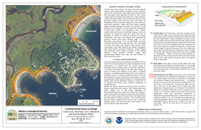
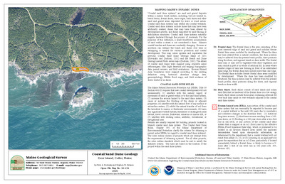
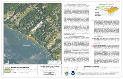
Beach and Dune Geology Aerial Photo: Crescent Surf Beach, Kennebunk
Stephen M. Dickson
Maine Geological Survey, Open-File Map 01-408 (Superseded by Slovinsky and Dickson, 2011, Maine Geological Survey, Open-file Map 11-88)
-

Beach and Dune Geology Aerial Photo: Crsecent Surf Beach, Parsons Beach, Kennebunk
Stephen M. Dickson
Maine Geological Survey, Open-File Map 01-409 (Superseded by Slovinsky and Dickson, 2011, Maine Geological Survey, Open-file Maps 11-88 and 11-89)
-

Beach and Dune Geology Aerial Photo: Curtis Cove, Braketts Point, Granite Point, Biddeford
Stephen M. Dickson
Maine Geological Survey, Open-File Map 01-427 (Superseded by Slovinsky and Dickson, 2011, Maine Geological Survey, Open-file Map 11-99)
-

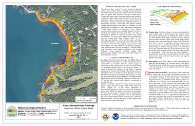
Beach and Dune Geology Aerial Photo: Drakes Island Beach, Laudholm Beach, Wells
Stephen M. Dickson
Maine Geological Survey, Open-File Map 01-412 (Superseded by Slovinsky and Dickson, 2011, Maine Geological Survey, Open-file Maps 11-86 and 11-87)
-

Beach and Dune Geology Aerial Photo: Drakes Island Beach, Webhannet River, Wells
Stephen M. Dickson
Maine Geological Survey, Open-File Map 01-411 (Superseded by Slovinsky and Dickson, 2011, Maine Geological Survey, Open-file Maps 11-85 and 11-86)
-

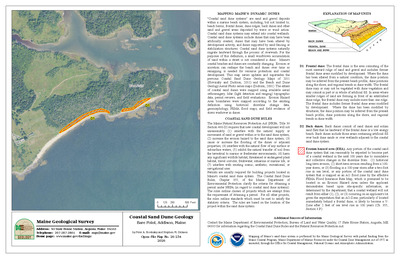
Beach and Dune Geology Aerial Photo: Ferry Beach, Bay View, Saco
Stephen M. Dickson
Maine Geological Survey, Open-File Map 01-400 (Superseded by by Slovinsky and Dickson, 2011, Maine Geological Survey Open-File Maps 11-109 and 110)
-

Beach and Dune Geology Aerial Photo: Ferry Beach, Scarborough
Stephen M. Dickson
Maine Geological Survey, Open-File Map 01-466 (Superseded by Slovinsky and Dickson, 2011, Maine Geological Survey, Open-file Map 11-120)
-

Beach and Dune Geology Aerial Photo: Ferry Beach State Park, Ferry Beach, Saco
Stephen M. Dickson
Maine Geological Survey, Open-File Map 01-399 (Superseded by by Slovinsky and Dickson, 2011, Maine Geological Survey Open-File Maps 11-108 and 11-109)
-

Beach and Dune Geology Aerial Photo: Ferry Beach, Western Beach, Scarborough
Stephen M. Dickson
Maine Geological Survey, Open-File Map 01-465 (Superseded by Slovinsky and Dickson, 2011, Maine Geological Survey, Open-file Maps 11-120 and 11-121)
-

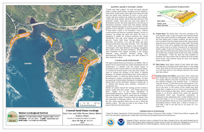
Beach and Dune Geology Aerial Photo: Fishermans Cove, Moody Point, Wells
Stephen M. Dickson
Maine Geological Survey, Open-File Map 01-441 (Superseded by Slovinsky and Dickson, 2011, Maine Geological Survey, Open-file Map 11-81)
-

Beach and Dune Geology Aerial Photo: Fort Popham, Atkins Bay, Phippsburg
Stephen M. Dickson
Maine Geological Survey, Open-File Map 01-458 (Superseded by Slovinsky and Dickson, 2011, Maine Geological Survey, Open-file Map 11-143)
-

Beach and Dune Geology Aerial Photo: Fortunes Rocks Beach, Fortunes Rock, Biddeford
Stephen M. Dickson
Maine Geological Survey, Open-File Map 01-417 (Superseded by Slovinsky and Dickson, 2011, Maine Geological Survey, Open-file Map 11-101)
-

Beach and Dune Geology Aerial Photo: Fortunes Rocks Beach, The Pool, Biddeford
Stephen M. Dickson
Maine Geological Survey, Open-File Map 01-416 (Superseded by Slovinsky and Dickson, 2011, Maine Geological Survey, Open-file Map 11-102)
-

Beach and Dune Geology Aerial Photo: Goochs Beach, Kennebunk River, Kennebunk
Stephen M. Dickson
Maine Geological Survey, Open-File Map 01-432 (Superseded by Slovinsky and Dickson, 2011, Maine Geological Survey, Open-file Map 11-94)
-

Beach and Dune Geology Aerial Photo: Goochs Beach, Middle Beach, Kennebunk
Stephen M. Dickson
Maine Geological Survey, Open-File Map 01-431 (Superseded by Slovinsky and Dickson, 2011, Maine Geological Survey, Open-file Map 11-93)
-

Beach and Dune Geology Aerial Photo: Goose Rocks Beach, Batson River, Kennebunkport
Stephen M. Dickson
Maine Geological Survey, Open-File Map 01-418 (Superseded by Slovinsky and Dickson, 2011, Maine Geological Survey, Open-file Map 11-95)
-

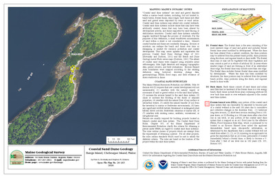
Beach and Dune Geology Aerial Photo: Goose Rocks Beach, Kennebunkport
Stephen M. Dickson
Maine Geological Survey, Open-File Map 01-420 (Superseded by Slovinsky and Dickson, 2011, Maine Geological Survey, Open-file Maps 11-96 and 11-97)
-

Beach and Dune Geology Aerial Photo: Goose Rocks Beach, Little River, Kennebunkport
Stephen M. Dickson
Maine Geological Survey, Open-File Map 01-421 (Superseded by Slovinsky and Dickson, 2011, Maine Geological Survey, Open-file Map 11-97 and 11-98)
-

Beach and Dune Geology Aerial Photo: Goose Rocks Beach, Smith Brook, Kennebunkport
Stephen M. Dickson
Maine Geological Survey, Open-File Map 01-419 (Superseded by Slovinsky and Dickson, 2011, Maine Geological Survey, Open-file Maps 11-95 and 11-96)
-

Beach and Dune Geology Aerial Photo: Grand Beach, Scarborough
Stephen M. Dickson
Maine Geological Survey, Open-File Map 01-452 (Superseded by Slovinsky and Dickson, 2011, Maine Geological Survey, Open-file Map 11-118)
-

Beach and Dune Geology Aerial Photo: Grand Beach, Surfside Beach, Old Orchard Beach
Stephen M. Dickson
Maine Geological Survey, Open-File Map 01-451 (Superseded by Slovinsky and Dickson, 2011, Maine Geological Survey, Open-file Map 11-117)
-

Beach and Dune Geology Aerial Photo: Griffith Head, Reid State Park, Georgetown
Stephen M. Dickson
Maine Geological Survey, Open-File Map 01-462 (Superseded by Slovinsky and Dickson, 2011, Maine Geological Survey, Open-file Map 11-145
-

Beach and Dune Geology Aerial Photo: Half Mile Beach, Little River, Georgetown
Stephen M. Dickson
Maine Geological Survey, Open-File Map 01-459 (Superseded by Slovinsky and Dickson, 2011, Maine Geological Survey, Open-file Map 11-144)
-

Beach and Dune Geology Aerial Photo: Half Mile Beach, Reid State Park, Georgetown
Stephen M. Dickson
Maine Geological Survey, Open-File Map 01-460 (Superseded by Slovinsky and Dickson, 2011, Maine Geological Survey, Open-file Map 11-144)
-

Beach and Dune Geology Aerial Photo: Higgins Beach, Scarborough
Stephen M. Dickson
Maine Geological Survey, Open-File Map 01-422 (Superseded by Slovinsky and Dickson, 2011, Maine Geological Survey, Open-file Map 11-126)
-

Beach and Dune Geology Aerial Photo: Higgins Beach, Spurwink River, Scarborough
Stephen M. Dickson
Maine Geological Survey, Open-File Map 01-423 (Superseded by Slovinsky and Dickson, 2011, Maine Geological Survey, Open-file Map 11-126)
-

Beach and Dune Geology Aerial Photo: Hills Beach, Biddeford
Stephen M. Dickson
Maine Geological Survey, Open-File Map 01-425 (Superseded by Slovinsky and Dickson, 2011, Maine Geological Survey, Open-file Map 11-106)
-

Beach and Dune Geology Aerial Photo: Hills Beach, Fort Hill, Biddeford
Stephen M. Dickson
Maine Geological Survey, Open-File Map 01-424 (Superseded by Slovinsky and Dickson, 2011, Maine Geological Survey, Open-file Maps 11-105 and 11-106)
-

Beach and Dune Geology Aerial Photo: Hills Beach, Saco River, Biddeford
Stephen M. Dickson
Maine Geological Survey, Open-File Map 01-426 (Superseded by Slovinsky and Dickson, 2011, Maine Geological Survey, Open-file Map 11-107)
-

Beach and Dune Geology Aerial Photo: Horseshoe Cove, New Barn Cove, Biddeford
Stephen M. Dickson
Maine Geological Survey, Open-File Map 01-428 (Superseded by Slovinsky and Dickson, 2011, Maine Geological Survey, Open-file Map 11-100)
-

Beach and Dune Geology Aerial Photo: Hunnewell Beach, Phippsburg
Stephen M. Dickson
Maine Geological Survey, Open-File Map 01-456 (Superseded by Slovinsky and Dickson, 2011, Maine Geological Survey, Open-file Map 11-141)
-

Beach and Dune Geology Aerial Photo: Hunnewell Beach, Popham Beach, Phippsburg
Stephen M. Dickson
Maine Geological Survey, Open-File Map 01-455 (Superseded by Slovinsky and Dickson, 2011, Maine Geological Survey, Open-file Map 11-140)
-

Beach and Dune Geology Aerial Photo: Jordan Point Beach, Breakwater Farm, Cape Elizabeth
Stephen M. Dickson
Maine Geological Survey, Open-File Map 01-405 (Superseded by Slovinsky and Dickson, 2011, Maine Geological Survey, Open-file Map 11-129)
-

Beach and Dune Geology Aerial Photo: Kennebunk Beach, Middle Beach, Kennebunk
Stephen M. Dickson
Maine Geological Survey, Open-File Map 01-430 (Superseded by Slovinsky and Dickson, 2011, Maine Geological Survey, Open-file Map 11-92)
-

Beach and Dune Geology Aerial Photo: Kinney Shores, Bay View, Saco
Stephen M. Dickson
Maine Geological Survey, Open-File Map 01-401 (Superseded by by Slovinsky and Dickson, 2011, Maine Geological Survey Open-File Map 11-110 and 11-111)
-

Beach and Dune Geology Aerial Photo: Kinney Shores, Goosefare Brook, Saco
Stephen M. Dickson
Maine Geological Survey, Open-File Map 01-402 (Superseded by Slovinsky and Dickson, 2011, Maine Geological Survey, Open-file Map 11-111 and 11-112)
-

Beach and Dune Geology Aerial Photo: Laudholm Beach, Little River, Wells
Stephen M. Dickson
Maine Geological Survey, Open-File Map 01-413 (Superseded by Slovinsky and Dickson, 2011, Maine Geological Survey, Open-file Map 11-87
-

Beach and Dune Geology Aerial Photo: Long Beach, Lobster Cove, York
Stephen M. Dickson
Maine Geological Survey, Open-File Map 01-433 (Superseded by Slovinsky and Dickson, 2011, Maine Geological Survey, Open-file Map 11-71)
-

Beach and Dune Geology Aerial Photo: Long Beach, Prebles Point, York
Stephen M. Dickson
Maine Geological Survey, Open-File Map 01-434 (Superseded by Slovinsky and Dickson, 2011, Maine Geological Survey, Open-file Maps 11-71 and 11-72)
-

Beach and Dune Geology Aerial Photo: Long Beach, Railroad Avenue, York
Stephen M. Dickson
Maine Geological Survey, Open-File Map 01-436 (Superseded by Slovinsky and Dickson, 2011, Maine Geological Survey, Open-file Map 11-74)
-

Beach and Dune Geology Aerial Photo: Long Beach, York
Stephen M. Dickson
Maine Geological Survey, Open-File Map 01-435 (Superseded by Slovinsky and Dickson, 2011, Maine Geological Survey, Open-file Map 11-73)
-

Beach and Dune Geology Aerial Photo: Lords Point, Strawberry Island, Kennebunk
Stephen M. Dickson
Maine Geological Survey, Open-File Map 01-429 (Superseded by Slovinsky and Dickson, 2011, Maine Geological Survey, Open-file Maps 11-90 and 11-91)
-

Beach and Dune Geology Aerial Photo: Main Beach, Ram Island, Cape Elizabeth
Stephen M. Dickson
Maine Geological Survey, Open-File Map 01-403 (Superseded by Slovinsky and Dickson, 2011, Maine Geological Survey, Open-file Map 11-127)
-

Beach and Dune Geology Aerial Photo: Mile Beach, Reid State Park, Georgetown
Stephen M. Dickson
Maine Geological Survey, Open-File Map 01-461 (Superseded by Slovinsky and Dickson, 2011, Maine Geological Survey, Open-file Map 11-145)
-

Beach and Dune Geology Aerial Photo: Mile Stretch Beach, South Point, Biddeford
Stephen M. Dickson
Maine Geological Survey, Open-File Map 01-414 (Superseded by Slovinsky and Dickson, 2011, Maine Geological Survey, Open-file Map 11-104)
-

Beach and Dune Geology Aerial Photo: Mile Stretch Beach, The Pool, Biddeford
Stephen M. Dickson
Maine Geological Survey, Open-File Map 01-415 (Superseded by Slovinsky and Dickson, 2011, Maine Geological Survey, Open-file Map 11-103)
-

Beach and Dune Geology Aerial Photo: Moody Beach, Ogunquit Beach, Wells
Stephen M. Dickson
Maine Geological Survey, Open-File Map 01-438 (Superseded by Slovinsky and Dickson, 2011, Maine Geological Survey, Open-file Maps 11-78 and 11-79)
-

Beach and Dune Geology Aerial Photo: Moody Beach, Wells
Stephen M. Dickson
Maine Geological Survey, Open-File Map 01-439 (Superseded by Slovinsky and Dickson, 2011, Maine Geological Survey, Open-file Maps 11-79 and 11-80)
-

Beach and Dune Geology Aerial Photo: Moody Point, Moody Beach, Wells
Stephen M. Dickson
Maine Geological Survey, Open-File Map 01-440 (Superseded by Slovinsky and Dickson, 2011, Maine Geological Survey, Open-file Map 11-80)
-

Beach and Dune Geology Aerial Photo: Ocean Park Beach, Old Orchard Beach
Stephen M. Dickson
Maine Geological Survey, Open-File Map 01-445 (Superseded by Slovinsky and Dickson, 2011, Maine Geological Survey, Open-file Map 11-112)
-

Beach and Dune Geology Aerial Photo: Ogunquit Beach, Beach Street, Ogunquit
Stephen M. Dickson
Maine Geological Survey, Open-File Map 01-443 (Superseded by Slovinsky and Dickson, 2011, Maine Geological Survey, Open-file Map 11-76 and 11-77)
-

Beach and Dune Geology Aerial Photo: Ogunquit Beach, Ogunquit
Stephen M. Dickson
Maine Geological Survey, Open-File Map 01-444 (Superseded by Slovinsky and Dickson, 2011, Maine Geological Survey, Open-file Map 11-77 and 11-78)
-

Beach and Dune Geology Aerial Photo: Ogunquit Beach, Ogunquit River, Ogunquit
Stephen M. Dickson
Maine Geological Survey, Open-File Map 01-442 (Superseded by Slovinsky and Dickson, 2011, Maine Geological Survey, Open-file Map 11-76)
-

Beach and Dune Geology Aerial Photo: Old Orchard Beach, Surfside Beach, Old Orchard Beach
Stephen M. Dickson
Maine Geological Survey, Open-File Map 01-449 (Superseded by Slovinsky and Dickson, 2011, Maine Geological Survey, Open-file Maps 11-115 and 11-116)
-

Beach and Dune Geology Aerial Photo: Old Orchard Beach, West Grand Avenue, Old Orchard Beach
Stephen M. Dickson
Maine Geological Survey, Open-File Map 01-447 (Superseded by Slovinsky and Dickson, 2011, Maine Geological Survey, Open-file Maps 11-113 and 11-114)
-

Beach and Dune Geology Aerial Photo: Parsons Beach, Great Hill, Kennebunk
Stephen M. Dickson
Maine Geological Survey, Open-File Map 01-410 (Superseded by Slovinsky and Dickson, 2011, Maine Geological Survey, Open-file Maps 11-89 and 11-90)
-

Beach and Dune Geology Aerial Photo: Pine Point Beach, Pine Point, Scarborough
Stephen M. Dickson
Maine Geological Survey, Open-File Map 01-454 (Superseded by Slovinsky and Dickson, 2011, Maine Geological Survey, Open-file Map 11-117)
-

Beach and Dune Geology Aerial Photo: Pine Point Beach, Scarborough
Stephen M. Dickson
Maine Geological Survey, Open-File Map 01-453 (Superseded by Slovinsky and Dickson, 2011, Maine Geological Survey, Open-file Map 11-118)
-

Beach and Dune Geology Aerial Photo: Popham Beach, Phippsburg
Stephen M. Dickson
Maine Geological Survey, Open-File Map 01-473 (Superseded by Slovinsky and Dickson, 2011, Maine Geological Survey, Open-file Maps 11-138 and 11-139)
-

Beach and Dune Geology Aerial Photo: Prouts Neck, East Point, Scarborough
Stephen M. Dickson
Maine Geological Survey, Open-File Map 01-463 (Superseded by Slovinsky and Dickson, 2011, Maine Geological Survey, Open-file Map 11-123)
-

Beach and Dune Geology Aerial Photo: Prouts Neck, Scarborough
Stephen M. Dickson
Maine Geological Survey, Open-File Map 01-467 (Superseded by Slovinsky and Dickson, 2011, Maine Geological Survey, Open-file Map 11-122)
-

Beach and Dune Geology Aerial Photo: Scarborough Beach,
Stephen M. Dickson
Maine Geological Survey, Open-File Map 01-464 (Superseded by Slovinsky and Dickson, 2011, Maine Geological Survey, Open-file Maps 11-121, 11-122, and 11-123)
-

Beach and Dune Geology Aerial Photo: Scarborough Beach, Scarborough
Stephen M. Dickson
Maine Geological Survey, Open-File Map 01-469 (Superseded by Slovinsky and Dickson, 2011, Maine Geological Survey, Open-file Map 11-125)
-

Beach and Dune Geology Aerial Photo: Scarborough Beach, Scarborough Beach State Park, Scarborough
Stephen M. Dickson
Maine Geological Survey, Open-File Map 01-468 (Superseded by Slovinsky and Dickson, 2011, Maine Geological Survey, Open-file Map 11-124)
-

Beach and Dune Geology Aerial Photo: Seawall Beach, Morse River, Phippsburg
Stephen M. Dickson
Maine Geological Survey, Open-File Map 01-472 (Superseded by Slovinsky and Dickson, 2011, Maine Geological Survey, Open-file Maps 11-137 and 11-138)
-

Beach and Dune Geology Aerial Photo: Seawall Beach, Phippsburg
Stephen M. Dickson
Maine Geological Survey, Open-File Map 01-471 (Superseded by Slovinsky and Dickson, 2011, Maine Geological Survey, Open-file Maps 11-136 and 11-137)
-

Beach and Dune Geology Aerial Photo: Seawall Beach, Sprague River, Phippsburg
Stephen M. Dickson
Maine Geological Survey, Open-File Map 01-470 (Superseded by Slovinsky and Dickson, 2011, Maine Geological Survey, Open-file Map 11-136)
-

Beach and Dune Geology Aerial Photo: Short Sands Beach, York
Stephen M. Dickson
Maine Geological Survey, Open-File Map 01-437 (Superseded by Slovinsky and Dickson, 2011, Maine Geological Survey, Open-file Map 11-75)
-

Beach and Dune Geology Aerial Photo: Strawberry Hill Beach, Cape Elizabeth
Stephen M. Dickson
Maine Geological Survey, Open-File Map 01-404 (Superseded by Slovinsky and Dickson, 2011, Maine Geological Survey, Open-file Map 11-128)
-

Beach and Dune Geology Aerial Photo: Surfside Beach, Old Orchard Beach
Stephen M. Dickson
Maine Geological Survey, Open-File Map 01-450 (Superseded by Slovinsky and Dickson, 2011, Maine Geological Survey, Open-file Map 11-116)
-

Beach and Dune Geology Aerial Photo: Wells Beach, Casino Point, Wells
Stephen M. Dickson
Maine Geological Survey, Open-File Map 01-475 (Superseded by Slovinsky and Dickson, 2011, Maine Geological Survey, Open-file Map 11-82 and 11-83)
-

Beach and Dune Geology Aerial Photo: Wells Beach, Fishermans Cove, Wells
Stephen M. Dickson
Maine Geological Survey, Open-File Map 01-474 (Superseded by Slovinsky and Dickson, 2011, Maine Geological Survey, Open-file Map 11-82)
-

Beach and Dune Geology Aerial Photo: Wells Beach, Webhannet River, Wells
Stephen M. Dickson
Maine Geological Survey, Open-File Map 01-477 (Superseded by Slovinsky and Dickson, 2011, Maine Geological Survey, Open-file Map 11-84 and 11-85)
-

Beach and Dune Geology Aerial Photo: Wells Beach, Wells
Stephen M. Dickson
Maine Geological Survey, Open-File Map 01-476 (Superseded by Slovinsky and Dickson, 2011, Maine Geological Survey, Open-file Maps 11-83 and 11-84)
-

Bedrock geology of North Haven and Vinalhaven Islands
Olcott Gates
Maine Geological Survey, Open-File Map 01-352.
-

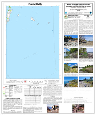
Coastal landslide hazards in the Bailey Island quadrangle, Maine
Stephen M. Dickson
Maine Geological Survey, Open-File Map 01-497
-

Coastal landslide hazards in the Bangor quadrangle, Maine
Stephen M. Dickson
Maine Geological Survey, Open-File Map 01-498
-

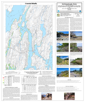
Coastal landslide hazards in the Bath quadrangle, Maine
Stephen M. Dickson
Maine Geological Survey, Open-File Map 01-500
-

Coastal landslide hazards in the Belfast quadrangle, Maine
Stephen M. Dickson
Maine Geological Survey, Open-File Map 01-501
-

Coastal landslide hazards in the Biddeford Pool quadrangle, Maine
Stephen M. Dickson
Maine Geological Survey, Open-File Map 01-503
-

Coastal landslide hazards in the Biddeford quadrangle, Maine
Stephen M. Dickson
Maine Geological Survey, Open-File Map 01-502
-

Coastal landslide hazards in the Blue Hill quadrangle, Maine
Stephen M. Dickson
Maine Geological Survey, Open-File Map 01-504
-

Coastal landslide hazards in the Bristol quadrangle, Maine
Stephen M. Dickson
Maine Geological Survey, Open-File Map 01-506
-

Coastal landslide hazards in the Brooklin quadrangle, Maine
Stephen M. Dickson
Maine Geological Survey, Open-File Map 01-507
-

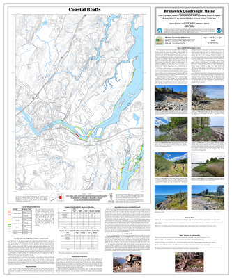
Coastal landslide hazards in the Brunswick quadrangle, Maine
Stephen M. Dickson
Maine Geological Survey, Open-File Map 01-509
-

Coastal landslide hazards in the Bucksport quadrangle, Maine
Stephen M. Dickson
Maine Geological Survey, Open-File Map 01-508
-

Coastal landslide hazards in the Camden quadrangle, Maine
Stephen M. Dickson
Maine Geological Survey, Open-File Map 01-510
-

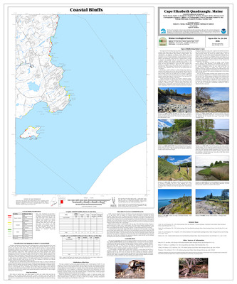
Coastal landslide hazards in the Cape Elizabeth quadrangle, Maine
Stephen M. Dickson
Maine Geological Survey, Open-File Map 01-511
-

Coastal landslide hazards in the Damariscotta quadrangle, Maine
Stephen M. Dickson
Maine Geological Survey, Open-File Map 01-514
-

Coastal landslide hazards in the Dover East quadrangle, Maine
Stephen M. Dickson
Maine Geological Survey, Open-File Map 01-515
-

Coastal landslide hazards in the Ellsworth quadrangle, Maine
Stephen M. Dickson
Maine Geological Survey, Open-File Map 01-516
-

Coastal landslide hazards in the Freeport quadrangle, Maine
Stephen M. Dickson
Maine Geological Survey, Open-File Map 01-517
-

Coastal landslide hazards in the Friendship quadrangle, Maine
Stephen M. Dickson
Maine Geological Survey, Open-File Map 01-518
-

Coastal landslide hazards in the Hampden quadrangle, Maine
Stephen M. Dickson
Maine Geological Survey, Open-File Map 01-519
-

Coastal landslide hazards in the Hewett Island quadrangle, Maine
Stephen M. Dickson
Maine Geological Survey, Open-File Map 01-520
-

Coastal landslide hazards in the Kittery quadrangle, Maine
Stephen M. Dickson
Maine Geological Survey, Open-File Map 01-522
-

Coastal landslide hazards in the Lincolnville quadrangle, Maine
Stephen M. Dickson
Maine Geological Survey, Open-File Map 01-523
-

Coastal landslide hazards in the Louds Island quadrangle, Maine
Stephen M. Dickson
Maine Geological Survey, Open-File Map 01-524
-

Coastal landslide hazards in the Monhegan quadrangle, Maine
Stephen M. Dickson
Maine Geological Survey, Open-File Map 01-525
-

Coastal landslide hazards in the Newbury Neck quadrangle, Maine
Stephen M. Dickson
Maine Geological Survey, Open-File Map 01-527
-

Coastal landslide hazards in the New Harbor quadrangle, Maine
Stephen M. Dickson
Maine Geological Survey, Open-File Map 01-526
-

Coastal landslide hazards in the Old Orchard Beach quadrangle, Maine
Stephen M. Dickson
Maine Geological Survey, Open-File Map 01-528
-

Coastal landslide hazards in the Orland quadrangle, Maine
Stephen M. Dickson
Maine Geological Survey, Open-File Map 01-529
-

Coastal landslide hazards in the Orrs Island quadrangle, Maine
Stephen M. Dickson
Maine Geological Survey, Open-File Map 01-530
-

Coastal landslide hazards in the Penobscot quadrangle, Maine
Stephen M. Dickson
Maine Geological Survey, Open-File Map 01-532
-

Coastal landslide hazards in the Phippsburg quadrangle, Maine
Stephen M. Dickson
Maine Geological Survey, Open-File Map 01-533
-

Coastal landslide hazards in the Portland East quadrangle, Maine
Stephen M. Dickson
Maine Geological Survey, Open-File Map 01-534
-

Coastal landslide hazards in the Portland West quadrangle, Maine
Stephen M. Dickson
Maine Geological Survey, Open-File Map 01-535
-

Coastal landslide hazards in the Portsmouth quadrangle, Maine
Stephen M. Dickson
Maine Geological Survey, Open-File Map 01-536