


The Maine Geological Survey provides the people and businesses of Maine with essential geologic information about the land where we live and work.
Note: Many state documents are offered in PDF format. To view PDF documents, you will need the free Adobe Reader. If you need assistance, view our Maine government PDF Help page or contact the contributing Maine State agency via the link on the left sidebar under “Links”.
-

Bedrock well depths in the Lincoln 30x60-minute quadrangle, Maine
Susan S. Tolman
Maine Geological Survey, Open-File Map 10-52.
-

Bedrock well depths in the Machias 30x60-minute quadrangle and a portion of the Eastport 30x60-minute quadrangle, Maine
Susan S. Tolman
Maine Geological Survey, Open-File Map 10-55.
-

Bedrock well depths in the Madawaska 30x60-minute quadrangle and portions of the Allagash and Van Buren 30x60-minute quadrangles, Maine
Susan S. Tolman
Maine Geological Survey, Open-File Map 10-58.
-

Bedrock well depths in the Portland 30x60-minute quadrangle, Maine
Susan S. Tolman
Maine Geological Survey, Open-File Map 10-64.
-

Bedrock well depths in the Presque Isle 30x60-minute quadrangle, Maine
Susan S. Tolman
Maine Geological Survey, Open-File Map 10-67.
-

Bedrock well depths in the Rumford 30x60-minute quadrangle, Maine
Susan S. Tolman
Maine Geological Survey, Open-File Map 10-70.
-

Bedrock well depths in the Skowhegan 30x60-minute quadrangle, Maine
Susan S. Tolman
Maine Geological Survey, Open-File Map 10-73.
-

Bedrock well yields in parts of the Millinocket and Danforth 30x60-minute quadrangles, Maine
Susan S. Tolman
Maine Geological Survey, Open-File Map 10-63.
-

Bedrock well yields in the Augusta 30x60-minute quadrangle, Maine
Susan S. Tolman
Maine Geological Survey, Open-File Map 10-25.
-

Bedrock well yields in the Bangor 30x60-minute quadrangle, Maine
Susan S. Tolman
Maine Geological Survey, Open-File Map 10-30.
-

Bedrock well yields in the Bar Harbor 30x60-minute quadrangle, Maine
Susan S. Tolman
Maine Geological Survey, Open-File Map 10-33.
-

Bedrock well yields in the Bath 30x60-minute quadrangle, Maine
Susan S. Tolman
Maine Geological Survey, Open-File Map 10-36.
-

Bedrock well yields in the Calais 30x60-minute quadrangle, Maine
Susan S. Tolman
Maine Geological Survey, Open-File Map 10-39.
-

Bedrock well yields in the Dover-Foxcroft 30x60-minute quadrangle, Maine
Susan S. Tolman
Maine Geological Survey, Open-File Map 10-42.
-

Bedrock well yields in the Houlton 30x60-minute quadrangle, Maine
Susan S. Tolman
Maine Geological Survey, Open-File Map 10-45.
-

Bedrock well yields in the Kittery 30x60-minute quadrangle, Maine
Susan S. Tolman
Maine Geological Survey, Open-File Map 10-48.
-

Bedrock well yields in the Lewiston 30x60-minute quadrangle, Maine
Susan S. Tolman
Maine Geological Survey, Open-File Map 10-51.
-

Bedrock well yields in the Lincoln 30x60-minute quadrangle, Maine
Susan S. Tolman
Maine Geological Survey, Open-File Map 10-54.
-

Bedrock well yields in the Machias 30x60-minute quadrangle and a portion of the Eastport 30x60-minute quadrangle, Maine
Susan S. Tolman
Maine Geological Survey, Open-File Map 10-57.
-

Bedrock well yields in the Madawaska 30x60-minute quadrangle and portions of the Allagash and Van Buren 30x60-minute quadrangles, Maine
Susan S. Tolman
Maine Geological Survey, Open-File Map 10-60.
-

Bedrock well yields in the Portland 30x60-minute quadrangle, Maine
Susan S. Tolman
Maine Geological Survey, Open-File Map 10-66.
-

Bedrock well yields in the Presque Isle 30x60-minute quadrangle, Maine
Susan S. Tolman
Maine Geological Survey, Open-File Map 10-69.
-

Bedrock well yields in the Rumford 30x60-minute quadrangle, Maine
Susan S. Tolman
Maine Geological Survey, Open-File Map 10-72.
-

Bedrock well yields in the Skowhegan 30x60-minute quadrangle, Maine
Susan S. Tolman
Maine Geological Survey, Open-File Map 10-75.
-

Overburden thickness in parts of the Millinocket and Danforth 30x60-minute quadrangles, Maine
Susan S. Tolman
Maine Geological Survey, Open-File Map 10-62.
-

Overburden thickness in the Augusta 30x60-minute quadrangle, Maine
Susan S. Tolman
Maine Geological Survey, Open-File Map 10-26.
-

Overburden thickness in the Bangor 30x60-minute quadrangle, Maine
Susan S. Tolman
Maine Geological Survey, Open-File Map 10-29.
-

Overburden thickness in the Bar Harbor 30x60-minute quadrangle, Maine
Susan S. Tolman
Maine Geological Survey, Open-File Map 10-32.
-

Overburden thickness in the Bath 30x60-minute quadrangle, Maine
Susan S. Tolman
Maine Geological Survey, Open-File Map 10-35.
-

Overburden thickness in the Calais 30x60-minute quadrangle, Maine
Susan S. Tolman
Maine Geological Survey, Open-File Map 10-38.
-

Overburden thickness in the Dover-Foxcroft 30x60-minute quadrangle, Maine
Susan S. Tolman
Maine Geological Survey, Open-File Map 10-41.
-

Overburden thickness in the Houlton 30x60-minute quadrangle, Maine
Susan S. Tolman
Maine Geological Survey, Open-File Map 10-44.
-

Overburden thickness in the Kittery 30x60-minute quadrangle, Maine
Susan S. Tolman
Maine Geological Survey, Open-File Map 10-47.
-

Overburden thickness in the Lewiston 30x60-minute quadrangle, Maine
Susan S. Tolman
Maine Geological Survey, Open-File Map 10-50.
-

Overburden thickness in the Lincoln 30x60-minute quadrangle, Maine
Susan S. Tolman
Maine Geological Survey, Open-File Map 10-53.
-

Overburden thickness in the Machias 30x60-minute quadrangle and a portion of the Eastport 30x60-minute quadrangle, Maine
Susan S. Tolman
Maine Geological Survey, Open-File Map 10-56.
-

Overburden thickness in the Madawaska 30x60-minute quadrangle and portions of the Allagash and Van Buren 30x60-minute quadrangles, Maine
Susan S. Tolman
Maine Geological Survey, Open-File Map 10-59.
-

Overburden thickness in the Portland 30x60-minute quadrangle, Maine
Susan S. Tolman
Maine Geological Survey, Open-File Map 10-65.
-

Overburden thickness in the Presque Isle 30x60-minute quadrangle, Maine
Susan S. Tolman
Maine Geological Survey, Open-File Map 10-68.
-

Overburden thickness in the Rumford 30x60-minute quadrangle, Maine
Susan S. Tolman
Maine Geological Survey, Open-File Map 10-71.
-

Overburden thickness in the Skowhegan 30x60-minute quadrangle, Maine
Susan S. Tolman
Maine Geological Survey, Open-File Map 10-74.
-

Surficial geology of the Bangor quadrangle, Maine
Kent M. Syverson and Andrew H. Thompson
Maine Geological Survey, Open-File Map 10-2 (Superseded by Syverson and Olson, 2011, Maine Geological Survey Open-file Map 11-6).
-

Surficial geology of the Camden quadrangle, Maine
Woodrow B. Thompson
Maine Geological Survey, Open-File Map 10-6.
-

Surficial geology of the Ellsworth quadrangle, Maine
Thomas K. Weddle
Maine Geological Survey, Open-File Map 10-14 (Superseded by Weddle, 2011, Maine Geological Survey Open-file Map 11-33).
-

Surficial geology of the Hancock quadrangle, Maine
Carol T. Hildreth
Maine Geological Survey, Open-File Map 10-23 (Superseded by Hildreth, 2011, Maine Geological Survey Open-file Map 11-34).
-

Surficial geology of the Old Town quadrangle, Maine
Alice R. Kelley and Joseph T. Kelley
Maine Geological Survey, Open-File Map 10-3 (Superseded by Kelley and Kelley, 2012, Maine Geological Survey Open-File Map 12-15).
-

Surficial geology of the Rockland quadrangle, Maine
Woodrow B. Thompson
Maine Geological Survey, Open-File Map 10-8.
-

Surficial geology of the Thomaston quadrangle, Maine
Woodrow B. Thompson
Maine Geological Survey, Open-File Map 10-10 (Superseded by Thompson, 2011, Maine Geological Survey Open-file Map 11-30).
-

Surficial geology of the Weeks Mills quadrangle, Maine
Thomas K. Weddle
Maine Geological Survey, Open-File Map 10-1.
-

Surficial geology of the West Rockport quadrangle, Maine
Woodrow B. Thompson
Maine Geological Survey, Open-File Map 10-12.
-

Surficial materials of the Camden quadrangle, Maine
Woodrow B. Thompson
Maine Geological Survey, Open-File Map 10-5.
-

Surficial materials of the Ellsworth quadrangle, Maine
Thomas K. Weddle and Daniel B. Locke
Maine Geological Survey, Open-File Map 10-13.
-

Surficial materials of the Hancock quadrangle, Maine
Carol T. Hildreth and Daniel B. Locke
Maine Geological Survey, Open-File Map 10-22.
-

Surficial materials of the Rockland quadrangle, Maine
Woodrow B. Thompson
Maine Geological Survey, Open-File Map 10-7.
-

Surficial materials of the Thomaston quadrangle, Maine
Woodrow B. Thompson
Maine Geological Survey, Open-File Map 10-9.
-

Surficial materials of the West Rockport quadrangle, Maine
Woodrow B. Thompson
Maine Geological Survey, Open-File Map 10-11.
-

Deglaciation features in the western half of the Augusta 1:100,000 quadrangle, Maine
Susan S. Tolman
Maine Geological Survey, Open-File Map 09-41.
-

Glacial ice-flow indicators in the western half of the Augusta 1:100,000 quadrangle, Maine
Susan S. Tolman
Maine Geological Survey, Open-File Map 09-42.
-

Landslide sites and areas of landslide susceptibility in the town of Alfred, Maine
Michael E. Foley and Marc C. Loiselle
Maine Geological Survey Open-File Report 09-20.
-

Landslide sites and areas of landslide susceptibility in the town of Arundel, Maine
Michael E. Foley and Marc C. Loiselle
Maine Geological Survey Open-File Report 09-21.
-

Landslide sites and areas of landslide susceptibility in the town of Berwick, Maine
Michael E. Foley and Marc C. Loiselle
Maine Geological Survey Open-File Report 09-22.
-

Landslide sites and areas of landslide susceptibility in the town of Biddeford, Maine
Michael E. Foley and Marc C. Loiselle
Maine Geological Survey Open-File Report 09-23.
-

Landslide sites and areas of landslide susceptibility in the town of Buxton, Maine
Michael E. Foley and Marc C. Loiselle
Maine Geological Survey Open-File Report 09-24.
-

Landslide sites and areas of landslide susceptibility in the town of Dayton, Maine
Michael E. Foley and Marc C. Loiselle
Maine Geological Survey Open-File Report 09-25.
-

Landslide sites and areas of landslide susceptibility in the town of Eliot, Maine
Michael E. Foley and Marc C. Loiselle
Maine Geological Survey Open-File Report 09-26.
-

Landslide sites and areas of landslide susceptibility in the town of Hollis, Maine
Michael E. Foley and Marc C. Loiselle
Maine Geological Survey Open-File Report 09-27.
-

Landslide sites and areas of landslide susceptibility in the town of Kennebunk, Maine
Michael E. Foley and Marc C. Loiselle
Maine Geological Survey Open-File Report 09-28.
-

Landslide sites and areas of landslide susceptibility in the town of Kennebunkport, Maine
Michael E. Foley and Marc C. Loiselle
Maine Geological Survey Open-File Report 09-29.
-

Landslide sites and areas of landslide susceptibility in the town of Kittery, Maine
Michael E. Foley and Marc C. Loiselle
Maine Geological Survey Open-File Report 09-30.
-

Landslide sites and areas of landslide susceptibility in the town of Lebanon, Maine
Michael E. Foley and Marc C. Loiselle
Maine Geological Survey Open-File Report 09-31.
-

Landslide sites and areas of landslide susceptibility in the town of Limington, Maine
Michael E. Foley and Marc C. Loiselle
Maine Geological Survey Open-File Report 09-32.
-

Landslide sites and areas of landslide susceptibility in the town of Lyman, Maine
Michael E. Foley and Marc C. Loiselle
Maine Geological Survey Open-File Report 09-33.
-

Landslide sites and areas of landslide susceptibility in the town of North Berwick, Maine
Michael E. Foley and Marc C. Loiselle
Maine Geological Survey Open-File Report 09-34.
-

Landslide sites and areas of landslide susceptibility in the town of Sanford, Maine
Michael E. Foley and Marc C. Loiselle
Maine Geological Survey Open-File Report 09-36.
-

Landslide sites and areas of landslide susceptibility in the town of South Berwick, Maine
Michael E. Foley and Marc C. Loiselle
Maine Geological Survey Open-File Report 09-37.
-

Landslide sites and areas of landslide susceptibility in the town of York, Maine
Michael E. Foley and Marc C. Loiselle
Maine Geological Survey Open-File Report 09-39.
-

Landslide sites and areas of landslide susceptibility in the towns of Saco and Old Orchard Beach, Maine
Michael E. Foley and Marc C. Loiselle
Maine Geological Survey Open-File Report 09-35.
-

Landslide sites and areas of landslide susceptibility in the towns of Wells and Ogunquit, Maine
Michael E. Foley and Marc C. Loiselle
Maine Geological Survey Open-File Report 09-38.
-

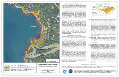
Significant sand and gravel aquifers in the Chemo Pond quadrangle, Maine
Lauren E. Foster, Troy T. Smith, Craig D. Neil, and John S. Williams
Maine Geological Survey, Open-File Map 01-39.
-

Significant sand and gravel aquifers in the East Pittston quadrangle, Maine
Craig D. Neil and Daniel B. Locke
Maine Geological Survey, Open-File Map 09-50.
-

Significant sand and gravel aquifers in the Hopkins Pond quadrangle, Maine
Craig D. Neil and Daniel B. Locke
Maine Geological Survey, Open-File Map 09-52.
-

Significant sand and gravel aquifers in the Kenduskeag quadrangle, Maine
Elizabeth B. Lewis, Daniel B. Locke, Craig D. Neil, and Thomas V. Lowell
Maine Geological Survey, Open-File Map 09-56.
-

Significant sand and gravel aquifers in the New Portland quadrangle, Maine
Elizabeth B. Lewis, Daniel B. Locke, Craig D. Neil, and Thomas K. Weddle
Maine Geological Survey, Open-File Map 09-53.
-

Significant sand and gravel aquifers in the North Whitefield quadrangle, Maine
Craig D. Neil and Daniel B. Locke
Maine Geological Survey, Open-File Map 09-55.
-

Significant sand and gravel aquifers in the Pushaw Lake quadrangle, Maine
Lauren E. Foster, Troy T. Smith, and Dale F. Doughty
Maine Geological Survey, Open-File Map 09-54.
-

Surficial geology of the Augusta quadrangle, Maine
Woodrow B. Thompson
Maine Geological Survey, Open-File Map 09-7.
-

Surficial geology of the Damariscotta quadrangle, Maine
Woodrow B. Thompson
Maine Geological Survey, Open-File Map 09-6.
-

Surficial geology of the East Pittston quadrangle, Maine
Woodrow B. Thompson
Maine Geological Survey, Open-File Map 09-9.
-

Surficial geology of the Gardiner quadrangle, Maine
Woodrow B. Thompson
Maine Geological Survey, Open-File Map 09-8.
-

Surficial geology of the Greenbush quadrangle, Maine
Roger LeB Hooke, Elizabet Metcalfe, and Robin Wiesner
Maine Geological Survey, Open-File Map 09-1 (Superseded by Hooke and others, 2016, Maine Geological Survey Open-File 16-3).
-

Surficial geology of the Kenduskeag quadrangle, Maine
Thomas K. Weddle
Maine Geological Survey, Open-File Map 09-16.
-

Surficial geology of the Kingfield quadrangle, Maine
Thomas K. Weddle
Maine Geological Survey, Open-File Map 09-49.
-

Surficial geology of the New Portland quadrangle, Maine
Carol T. Hildreth
Maine Geological Survey, Open-File Map 09-47.
-

Surficial geology of the New Vineyard quadrangle, Maine
Carol T. Hildreth
Maine Geological Survey, Open-File Map 09-48.
-

Surficial geology of the North Whitefield quadrangle, Maine
Woodrow B. Thompson
Maine Geological Survey, Open-File Map 09-11.
-

Surficial geology of the Pushaw Lake quadrangle, Maine
Alice R. Kelley and Lynn Caron
Maine Geological Survey, Open-File Map 09-18.
-

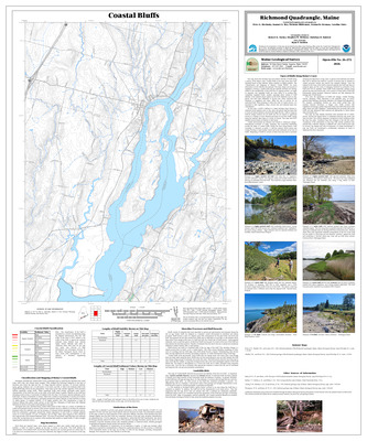
Surficial geology of the Richmond quadrangle, Maine
Thomas K. Weddle and Daniel S. Frost
Maine Geological Survey, Open-File Map 09-13.
-

Surficial geology of the western half of the Augusta 1:100,000 quadrangle, Maine
Susan S. Tolman
Maine Geological Survey, Open-File Map 09-40.
-

Surficial geology of the Wiscasset quadrangle, Maine
Woodrow B. Thompson
Maine Geological Survey, Open-File Map 09-4.
-

Surficial materials of the Chemo Pond quadrangle, Maine
Carol T. Hildreth, Craig D. Neil, and John S. Williams
Maine Geological Survey, Open-File Map 09-15.
-

Surficial materials of the Damariscotta quadrangle, Maine
Woodrow B. Thompson and Daniel B. Locke
Maine Geological Survey, Open-File Map 09-5.
-

Surficial materials of the East Pittston quadrangle, Maine
Woodrow B. Thompson and Daniel B. Locke
Maine Geological Survey, Open-File Map 09-10.
-

Surficial materials of the Kenduskeag quadrangle, Maine
Thomas K. Weddle and Thomas V. Lowell
Maine Geological Survey, Open-File Map 09-17.
-

Surficial materials of the North Whitefield quadrangle, Maine
Woodrow B. Thompson and Daniel B. Locke
Maine Geological Survey, Open-File Map 09-12.
-

Surficial materials of the Pushaw Lake quadrangle, Maine
Alice R. Kelley, Lynn Caron, and Dale F. Doughty
Maine Geological Survey, Open-File Map 09-19
-

Surficial materials of the Wiscasset quadrangle, Maine
Woodrow B. Thompson and Daniel B. Locke
Maine Geological Survey, Open-File Map 09-3
-

Bedrock geology of the Ellsworth quadrangle, Maine
Jeff Pollock
Maine Geological Survey, Open-File Map 08-88.
-

Bedrock geology of the Jefferson quadrangle, Maine
Henry N. Berry and Philip H. Osberg
Maine Geological Survey, Open-File Map 08-53.
-

Bedrock geology of the Kittery 1:100,000 quadrangle, Maine and New Hampshire
Arthur M. Hussey II, Wallace A. Bothner, and Peter J. Thompson
Maine Geological Survey, Geologic Map 08-78 (Superseded by Hussey, Bothner, and Thompson, 2016, Maine Geological Survey Open-File 16-6).
-

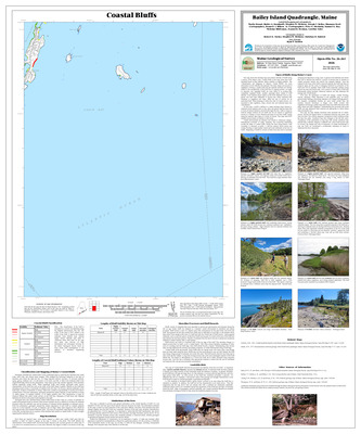
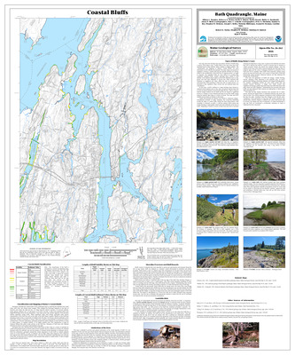
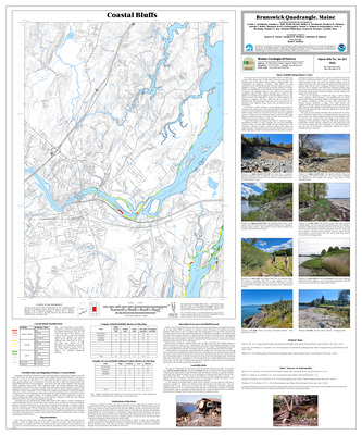
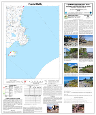
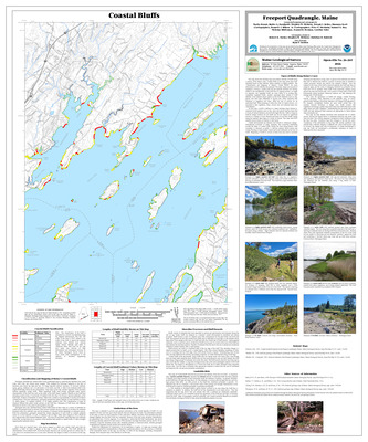
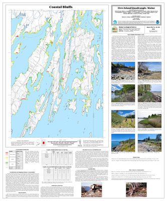
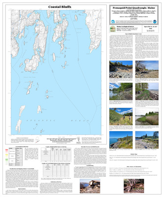
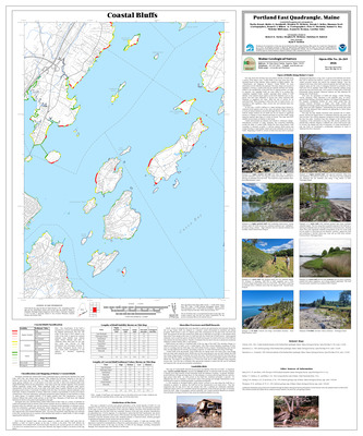
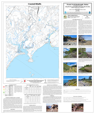
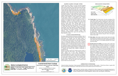
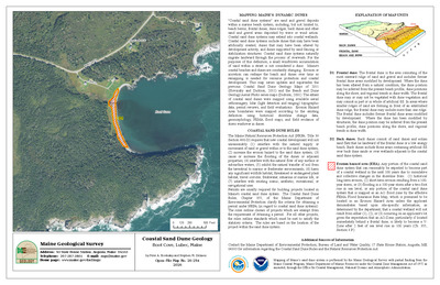
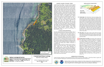
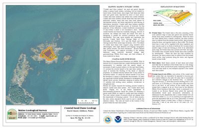
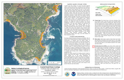
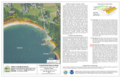
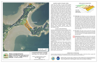
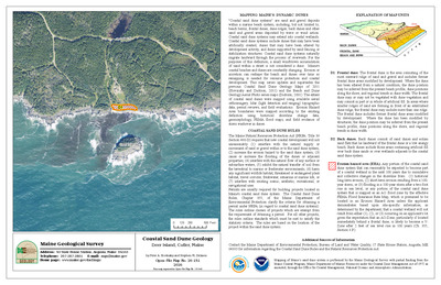
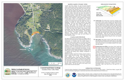
Coastal bluffs in the Pemaquid Point quadrangle, Maine
Thomas D. Henze, Douglas G. Hodum, Meredith A. Kelley, David A. Stinson, Allison L. Brandes, Stephen M. Dickson, and Joseph T. Kelley
Maine Geological Survey, Open-File Map 08-63 (Superseded by Henze et. al., 2026, Maine Geological Survey Open-File 26-267).
-

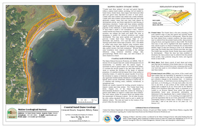
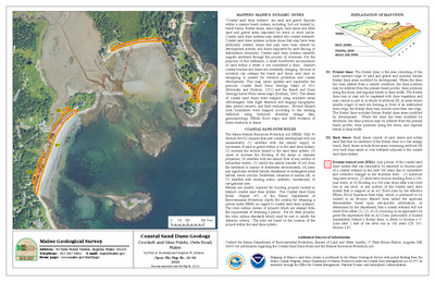
Coastal landslide hazards in the Pemaquid Point quadrangle, Maine
Stephen M. Dickson
Maine Geological Survey, Open-File Map 08-64.
-

Deglaciation features in the Lewiston 1:100,000 quadrangle, Maine
Susan S. Tolman
Maine Geological Survey, Open-File Map 08-50.
-

Glacial ice-flow indicators in the Lewiston 1:100,000 quadrangle, Maine
Susan S. Tolman
Maine Geological Survey, Open-File Map 08-51.
-

Significant sand and gravel aquifers in the Bangor quadrangle, Maine
Lauren E. Foster, Troy T. Smith, Craig D. Neil, and John S. Williams
Maine Geological Survey, Open-File Map 08-57.
-

Significant sand and gravel aquifers in the Basin Mountain quadrangle, Maine
Daniel B. Locke
Maine Geological Survey, Open-File Map 08-2.
-

Significant sand and gravel aquifers in the Big Shanty Mountain quadrangle, Maine
Craig D. Neil and Daniel B. Locke
Maine Geological Survey, Open-File Map 08-54.
-

Significant sand and gravel aquifers in the Big Spencer Mountain quadrangle, Maine
Robert A. Johnston
Maine Geological Survey, Open-File Map 08-9.
-

Significant sand and gravel aquifers in the Bryant Pond quadrangle, Maine
Craig D. Neil and Daniel B. Locke
Maine Geological Survey, Open-File Map 08-84.
-

Significant sand and gravel aquifers in the Caribou Lake North quadrangle, Maine
Daniel B. Locke
Maine Geological Survey, Open-File Map 08-19.
-

Significant sand and gravel aquifers in the Caribou Lake South quadrangle, Maine
Thomas K. Weddle
Maine Geological Survey, Open-File Map 08-21.
-

Significant sand and gravel aquifers in the East Carry Pond quadrangle, Maine
Elizabeth B. Lewis, Daniel B. Locke, and Craig D. Neil
Maine Geological Survey, Open-File Map 08-12.
-

Significant sand and gravel aquifers in the Enchanted Pond quadrangle, Maine
Daniel B. Locke
Maine Geological Survey, Open-File Map 08-6.
-

Significant sand and gravel aquifers in the Farrar Mountain quadrangle, Maine
Thomas K. Weddle
Maine Geological Survey, Open-File Map 08-23.
-

Significant sand and gravel aquifers in the Harrington Lake quadrangle, Maine
Daniel B. Locke
Maine Geological Survey, Open-File Map 08-25.
-

Significant sand and gravel aquifers in the Hay Mountain quadrangle, Maine
Craig D. Neil and Daniel B. Locke
Maine Geological Survey, Open-File Map 08-85.
-

Significant sand and gravel aquifers in the Jo-Mary Mountain quadrangle, Maine
Craig D. Neil and Daniel B. Locke
Maine Geological Survey, Open-File Map 08-55.
-

Significant sand and gravel aquifers in the King and Bartlett Lake quadrangle, Maine
Daniel B. Locke
Maine Geological Survey, Open-File Map 08-7.
-

Significant sand and gravel aquifers in the King and Bartlett Mountain Quadrangle, Maine
Daniel B. Locke
Maine Geological Survey, Open-File Map 08-11.
-

Significant sand and gravel aquifers in the Livermore Falls quadrangle, Maine
Craig D. Neil and Daniel B. Locke
Maine Geological Survey, Open-File Map 08-61.
-

Significant sand and gravel aquifers in the Old Town quadrangle, Maine
Lauren E. Foster, Troy T. Smith, Dale F. Doughty, and Edward B. Baker
Maine Geological Survey, Open-File Map 08-87.
-

Significant sand and gravel aquifers in the Pierce Pond quadrangle, Maine
Daniel B. Locke
Maine Geological Survey, Open-File Map 08-4.
-

Significant sand and gravel aquifers in the Pine Stream Flowage quadrangle, Maine
Daniel B. Locke
Maine Geological Survey, Open-File Map 08-27.
-

Significant sand and gravel aquifers in the Rainbow Lake West quadrangle, Maine
Michael E. Foley
Maine Geological Survey, Open-File Map 08-29.
-

Significant sand and gravel aquifers in the Spencer Lake quadrangle, Maine
Daniel B. Locke
Maine Geological Survey, Open-File Map 08-14.
-

Significant sand and gravel aquifers in the The Forks quadrangle, Maine
Craig D. Neil
Maine Geological Survey, Open-File Map 08-13.
-

Significant sand and gravel aquifers in the Turner Center quadrangle, Maine
Craig D. Neil and Daniel B. Locke
Maine Geological Survey, Open-File Map 08-59.
-

Significant sand and gravel aquifers in the Veazie quadrangle, Maine
Lauren E. Foster, Troy T. Smith, Craig D. Neil, and John S. Williams
Maine Geological Survey, Open-File Map 08-86.
-

Significant sand and gravel aquifers in the Wadleigh Mountain quadrangle, Maine
Thomas K. Weddle
Maine Geological Survey, Open-File Map 08-31.
-

Significant sand and gravel aquifers in the Wayne quadrangle, Maine
Craig D. Neil
Maine Geological Survey, Open-File Map 08-67.
-

Significant sand and gravel aquifers in the West Paris quadrangle, Maine
Craig D. Neil and Daniel B. Locke
Maine Geological Survey, Open-File Map 08-58.
-

Surficial geology of the Bethel quadrangle, Maine
Woodrow B. Thompson
Maine Geological Survey, Open-File Map 08-79.
-

Surficial geology of the Bridgton quadrangle, Maine
Carol T. Hildreth
Maine Geological Survey, Open-File Map 08-70.
-

Surficial geology of the Bryant Pond quadrangle, Maine
Woodrow B. Thompson
Maine Geological Survey, Open-File Map 08-80.
-

Surficial geology of the Buckfield quadrangle, Maine
Thomas K. Weddle and Jonathan W. Duchette
Maine Geological Survey, Open-File Map 08-68.
-

Surficial geology of the Canton quadrangle, Maine
Woodrow B. Thompson
Maine Geological Survey, Open-File Map 08-82.
-

Surficial geology of the Fayette quadrangle, Maine
Woodrow B. Thompson and Geoffrey W. Smith
Maine Geological Survey, Open-File Map 08-44.
-

Surficial geology of the Lake Auburn East quadrangle, Maine
Carol T. Hildreth
Maine Geological Survey, Open-File Map 08-72.
-

Surficial geology of the Lake Auburn West quadrangle, Maine
Woodrow B. Thompson
Maine Geological Survey, Open-File Map 08-69.
-

Surficial geology of the Lewiston 1:100,000 quadrangle, Maine
Susan S. Tolman
Maine Geological Survey, Open-File Map 08-49.
-

Surficial geology of the Livermore Falls quadrangle, Maine
Geoffrey W. Smith and Woodrow B. Thompson
Maine Geological Survey, Open-File Map 08-43.
-

Surficial geology of the Monmouth quadrangle, Maine
Michael E. Foley and Alexa A. Bernotavicz
Maine Geological Survey, Open-File Map 08-73.
-

Surficial geology of the Mount Zircon quadrangle, Maine
Woodrow B. Thompson
Maine Geological Survey, Open-File Map 08-38.
-

Surficial geology of the Norway quadrangle, Maine
Woodrow B. Thompson
Maine Geological Survey, Open-File Map 08-74.
-

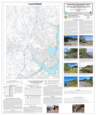
Surficial geology of the Portland West quadrangle, Maine
Woodrow B. Thompson
Maine Geological Survey, Open-File Map 08-16.
-

Surficial geology of the Turner Center quadrangle, Maine
Geoffrey W. Smith
Maine Geological Survey, Open-File Map 08-42.
-

Surficial geology of the Wayne quadrangle, Maine
Woodrow B. Thompson and Geoffrey W. Smith
Maine Geological Survey, Open-File Map 08-41.
-

Surficial geology of the West Paris quadrangle, Maine
Woodrow B. Thompson
Maine Geological Survey, Open-File Map 08-36.
-

Surficial geology of the West Sumner quadrangle, Maine
Carol T. Hildreth
Maine Geological Survey, Open-File Map 08-76.
-

Surficial geology of the Winthrop quadrangle, Maine
Woodrow B. Thompson
Maine Geological Survey, Open-File Map 08-75.
-

Surficial geology of the Worthley Pond quadrangle, Maine
Woodrow B. Thompson and John Dykstra Eusden Jr
Maine Geological Survey, Open-File Map 08-81.
-

Surficial materials of the Bangor quadrangle, Maine
Kent M. Syverson, Andrew H. Thompson, Craig D. Neil, and John S. Williams
Maine Geological Survey, Open-File Map 08-33.
-

Surficial materials of the Basin Mountain quadrangle, Maine
Daniel B. Locke
Maine Geological Survey, Open-File Map 08-1.
-

Surficial materials of the Big Spencer Mountain quadrangle, Maine
Robert A. Johnston
Maine Geological Survey, Open-File Map 08-8.
-

Surficial materials of the Caribou Lake North quadrangle, Maine
Daniel B. Locke
Maine Geological Survey, Open-File Map 08-18.
-

Surficial materials of the Caribou Lake South quadrangle, Maine
Thomas K. Weddle
Maine Geological Survey, Open-File Map 08-20.
-

Surficial materials of the Enchanted Pond quadrangle, Maine
Daniel B. Locke
Maine Geological Survey, Open-File Map 08-5.
-

Surficial materials of the Farrar Mountain quadrangle, Maine
Thomas K. Weddle
Maine Geological Survey, Open-File Map 08-22.
-

Surficial materials of the Fayette quadrangle, Maine
Daniel B. Locke
Maine Geological Survey, Open-File Map 08-65.
-

Surficial materials of the Greenbush quadrangle, Maine
Roger LeB Hooke, Robin Wiesner, Elizabet Metcalfe, Dale F. Doughty, and Edward B. Baker
Maine Geological Survey, Open-File Map 08-89.
-

Surficial materials of the Harrington Lake quadrangle, Maine
Daniel B. Locke
Maine Geological Survey, Open-File Map 08-24.
-

Surficial materials of the Hermon quadrangle, Maine
Thomas K. Weddle
Maine Geological Survey, Open-File Map 08-46.
-

Surficial materials of the King and Bartlett Lake quadrangle, Maine
Daniel B. Locke
Maine Geological Survey, Open-File Map 08-32.
-

Surficial materials of the King and Bartlett Mountain quadrangle, Maine
Daniel B. Locke
Maine Geological Survey, Open-File Map 08-10.
-

Surficial materials of the Livermore Falls quadrangle, Maine
Daniel B. Locke
Maine Geological Survey, Open-File Map 08-62.
-

Surficial materials of the Mount Zircon quadrangle, Maine
Woodrow B. Thompson and Daniel B. Locke
Maine Geological Survey, Open-File Map 08-17.
-

Surficial materials of the Old Town quadrangle, Maine
Alice R. Kelley, Joseph T. Kelley, Dale F. Doughty, and Edward B. Baker
Maine Geological Survey, Open-File Map 08-48.
-

Surficial materials of the Pierce Pond quadrangle, Maine
Daniel B. Locke
Maine Geological Survey, Open-File Map 08-3.
-

Surficial materials of the Pine Stream Flowage quadrangle, Maine
Daniel B. Locke
Maine Geological Survey, Open-File Map 08-26.
-

Surficial materials of the Rainbow Lake West quadrangle, Maine
Michael E. Foley
Maine Geological Survey, Open-File Map 08-28.
-

Surficial materials of the Spencer Lake quadrangle, Maine
Daniel B. Locke
Maine Geological Survey, Open-File Map 08-15.
-

Surficial materials of the Turner Center quadrangle, Maine
Daniel B. Locke
Maine Geological Survey, Open-File Map 08-60.
-

Surficial materials of the Veazie quadrangle, Maine
Carol T. Hildreth, Craig D. Neil, and John S. Williams
Maine Geological Survey, Open-File Map 08-40.
-

Surficial materials of the Wadleigh Mountain quadrangle, Maine
Thomas K. Weddle
Maine Geological Survey, Open-File Map 08-30.
-

Surficial materials of the Wayne quadrangle, Maine
Daniel B. Locke
Maine Geological Survey, Open-File Map 08-66.
-

Surficial materials of the West Paris quadrangle, Maine
Woodrow B. Thompson and Daniel B. Locke
Maine Geological Survey, Open-File Map 08-34.
-

Surficial materials of the Worthley Pond quadrangle, Maine
Woodrow B. Thompson and Daniel B. Locke
Maine Geological Survey, Open-File Map 08-77.
-

Bedrock geology of the Fletcher Peak quadrangle, Maine
Chunzeng Wang
Maine Geological Survey, Open-File Map 07-143.
-

Bedrock geology of the North Whitefield quadrangle, Maine
Timothy W. Grover
Maine Geological Survey, Open-File Map 07-55.
-

Deglaciation features in the Kittery 1:100,000 quadrangle, Maine
Susan S. Tolman
Maine Geological Survey Open-File Map 07-54.
-

Glacial ice-flow indicators in the Kittery 1:100,000 quadrangle, Maine
Susan S. Tolman
Maine Geological Survey Open-File Map 07-53.
-

Significant sand and gravel aquifers in the Beau Lake quadrangle, Maine
Thomas K. Weddle
Maine Geological Survey, Open-File Map 07-43.
-

Significant sand and gravel aquifers in the Big Rapids quadrangle, Maine
Daniel B. Locke
Maine Geological Survey, Open-File Map 07-61.
-

Significant sand and gravel aquifers in the Blue Hill quadrangle, Maine
Daniel B. Locke and Craig D. Neil
Maine Geological Survey, Open-File Map 07-2.
-

Significant sand and gravel aquifers in the East Lake SE quadrangle, Maine
Daniel B. Locke
Maine Geological Survey, Open-File Map 07-63.
-

Significant sand and gravel aquifers in the Estcourt quadrangle, Maine
Thomas K. Weddle
Maine Geological Survey, Open-File Map 07-47.
-

Significant sand and gravel aquifers in the Greenwood quadrangle, Maine
Craig D. Neil
Maine Geological Survey, Open-File Map 07-75.
-

Significant sand and gravel aquifers in the Hafey Pond quadrangle, Maine
Thomas K. Weddle
Maine Geological Survey, Open-File Map 07-45.
-

Significant sand and gravel aquifers in the Holeb quadrangle, Maine
Robert A. Johnston
Maine Geological Survey, Open-File Map 07-16
-

Significant sand and gravel aquifers in the Kibby Mountain quadrangle, Maine
Robert A. Johnston
Maine Geological Survey, Open-File Map 07-148.
-

Significant sand and gravel aquifers in the Kingfield quadrangle, Maine
Elizabeth B. Lewis, Daniel B. Locke, and Craig D. Neil
Maine Geological Survey, Open-File Map 07-76.
-

Significant sand and gravel aquifers in the Landry quadrangle, Maine
Thomas K. Weddle
Maine Geological Survey, Open-File Map 07-51.
-

Significant sand and gravel aquifers in the Mount Abraham quadrangle, Maine
Elizabeth B. Lewis, Daniel B. Locke, and Craig D. Neil
Maine Geological Survey, Open-File Map 07-97.
-

Significant sand and gravel aquifers in the Penobscot quadrangle, Maine
Daniel B. Locke and Craig D. Neil
Maine Geological Survey, Open-File Map 07-6.
-

Significant sand and gravel aquifers in the Rocky Brook quadrangle, Maine
Thomas K. Weddle
Maine Geological Survey, Open-File Map 07-49.
-

Significant sand and gravel aquifers in the Rocky Mountain NW quadrangle, Maine
Thomas K. Weddle
Maine Geological Survey, Open-File Map 07-41.
-

Significant sand and gravel aquifers in the Rocky Mountain SW quadrangle, Maine
Daniel B. Locke
Maine Geological Survey, Open-File Map 07-57.
-

Significant sand and gravel aquifers in the Salsbury Cove quadrangle, Maine
Daniel B. Locke and Craig D. Neil
Maine Geological Survey, Open-File Map 07-4.
-

Significant sand and gravel aquifers in the Schoolhouse Rapids quadrangle, Maine
Daniel B. Locke
Maine Geological Survey, Open-File Map 07-59.
-

Significant sand and gravel aquifers in the Skinner NE quadrangle, Maine
Robert A. Johnston
Maine Geological Survey, Open-File Map 07-14.
-

Significant sand and gravel aquifers in the Skinner quadrangle, Maine
Robert A. Johnston
Maine Geological Survey, Open-File Map 07-12.
-

Significant sand and gravel aquifers in the Stony Brook quadrangle, Maine
Robert A. Johnston
Maine Geological Survey, Open-File Map 07-10.
-

Significant sand and gravel aquifers in the Tumbledown Mountain quadrangle, Maine
Robert A. Johnston
Maine Geological Survey, Open-File Map 07-150.
-

Surficial geology of the Biddeford quadrangle, Maine
Carol T. Hildreth
Maine Geological Survey, Open-File Map 07-81.
-

Surficial geology of the Dover East quadrangle, Maine
Geoffrey W. Smith and Cornelia C. Cameron
Maine Geological Survey, Open-File Map 07-80.
-

Surficial geology of the Greenwood quadrangle, Maine
Woodrow B. Thompson
Maine Geological Survey, Open-File Map 07-67.
-

Surficial geology of the Kittery 1:100,000 quadrangle, Maine
Susan S. Tolman
Maine Geological Survey Open-File Map 07-52.
-

Surficial geology of the Strong quadrangle, Maine
Craig D. Neil
Maine Geological Survey, Open-File Map 07-77.
-

Surficial geology of the Togus Pond quadrangle
Woodrow B. Thompson
Maine Geological Survey, Open-File Map 07-101.
-

Surficial geology of the Waterford Flat quadrangle, Maine
Woodrow B. Thompson
Maine Geological Survey, Open-File Map 07-78.
-

Surficial materials of the Beau Lake quadrangle, Maine
Thomas K. Weddle
Maine Geological Survey, Open-File Map 07-42.
-

Surficial materials of the Big Rapids quadrangle, Maine
Daniel B. Locke
Maine Geological Survey, Open-File Map 07-62.
-

Surficial materials of the Blue Hill quadrangle, Maine
Glenn C. Prescott Jr and Daniel B. Locke
Maine Geological Survey, Open-File Map 07-1.
-

Surficial materials of the Boundary Pond quadrangle, Maine
Robert A. Johnston
Maine Geological Survey, Open-File Map 07-7.
-

Surficial materials of the Bryant Pond quadrangle, Maine
Woodrow B. Thompson and Daniel B. Locke
Maine Geological Survey, Open-File Map 07-66.
-

Surficial materials of the East Lake SE quadrangle, Maine
Daniel B. Locke
Maine Geological Survey, Open-File Map 07-64.
-

Surficial materials of the Estcourt quadrangle, Maine
Thomas K. Weddle
Maine Geological Survey, Open-File Map 07-46.
-

Surficial materials of the Greenwood quadrangle, Maine
Woodrow B. Thompson and Daniel B. Locke
Maine Geological Survey, Open-File Map 07-68.
-

Surficial materials of the Hafey Pond quadrangle, Maine
Thomas K. Weddle
Maine Geological Survey, Open-File Map 07-44.
-

Surficial materials of the Holeb quadrangle, Maine
Robert A. Johnston
Maine Geological Survey, Open-File Map 07-15.
-

Surficial materials of the Johnson Brook Mountain quadrangle, Maine
Thomas K. Weddle
Maine Geological Survey, Open-File Map 07-38.
-

Surficial materials of the Kibby Mountain quadrangle, Maine
Robert A. Johnston
Maine Geological Survey, Open-File Map 07-147.
-

Surficial materials of the Kingfield quadrangle, Maine
Thomas K. Weddle
Maine Geological Survey, Open-File Map 07-70.
-

Surficial materials of the Landry quadrangle, Maine
Thomas K. Weddle
Maine Geological Survey, Open-File Map 07-50.
-

Surficial materials of the Morrison Brook quadrangle, Maine
Thomas K. Weddle
Maine Geological Survey, Open-File Map 07-39.
-

Surficial materials of the New Portland quadrangle, Maine
Carol T. Hildreth and Thomas K. Weddle
Maine Geological Survey, Open-File Map 07-72.
-

Surficial materials of the New Vineyard quadrangle, Maine
Carol T. Hildreth and Daniel B. Locke
Maine Geological Survey, Open-File Map 07-74.
-

Surficial materials of the Penobscot quadrangle, Maine
Glenn C. Prescott Jr and Daniel B. Locke
Maine Geological Survey, Open-File Map 07-5.
-

Surficial materials of the Rocky Brook quadrangle, Maine
Thomas K. Weddle
Maine Geological Survey, Open-File Map 07-48.
-

Surficial materials of the Rocky Mountain NW quadrangle, Maine
Thomas K. Weddle
Maine Geological Survey, Open-File Map 07-40.
-

Surficial materials of the Rocky Mountain quadrangle, Maine
Thomas K. Weddle
Maine Geological Survey, Open-File Map 07-37.
-

Surficial materials of the Rocky Mountain SW quadrangle, Maine
Daniel B. Locke
Maine Geological Survey, Open-File Map 07-58.
-

Surficial materials of the Schoolhouse Rapids quadrangle, Maine
Daniel B. Locke
Maine Geological Survey, Open-File Map 07-60.
-

Surficial materials of the Skinner NE quadrangle, Maine
Robert A. Johnston
Maine Geological Survey, Open-File Map 07-13.
-

Surficial materials of the Skinner quadrangle, Maine
Robert A. Johnston
Maine Geological Survey, Open-File Map 07-11.
-

Surficial materials of the Stony Brook quadrangle, Maine
Robert A. Johnston
Maine Geological Survey, Open-File Map 07-9.
-

Surficial materials of the Tumbledown Mountain quadrangle, Maine
Robert A. Johnston
Maine Geological Survey, Open-File Map 07-149.
-

Bedrock geology of the Washington quadrangle, Maine
David P. West Jr
Maine Geological Survey, Open-File Map 06-79.
-

Coastal bluffs in the Addison quadrangle, Maine
Nicole A. Raineault, Christopher E. Miller, Stephen M. Dickson, and Joseph T. Kelley
Maine Geological Survey, Open-File Map 06-61.
-

Coastal bluffs in the Bar Harbor quadrangle, Maine
Corinn C. Keblinsky, Nathan C. Gardiner, Kristie A. Ferland, Jennifer L. Hall, Nicole A. Raineault, Christopher E. Miller, Stephen M. Dickson, and Joseph T. Kelley
Maine Geological Survey, Open-File Map 06-70.
-

Coastal bluffs in the Drisko Island quadrangle, Maine
Nicole A. Raineault, Christopher E. Miller, Stephen M. Dickson, and Joseph T. Kelley
Maine Geological Survey, Open-File Map 06-64