


The Maine Geological Survey provides the people and businesses of Maine with essential geologic information about the land where we live and work.
Note: Many state documents are offered in PDF format. To view PDF documents, you will need the free Adobe Reader. If you need assistance, view our Maine government PDF Help page or contact the contributing Maine State agency via the link on the left sidebar under “Links”.
-

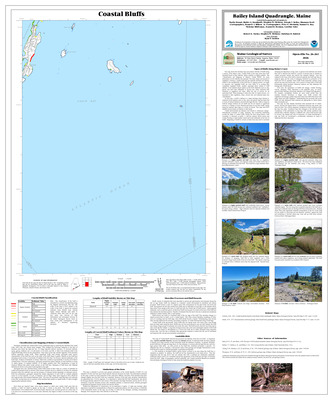
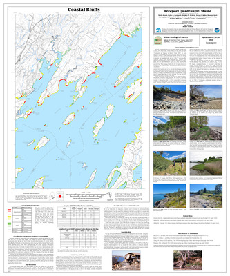
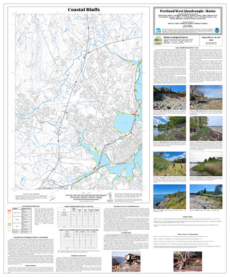
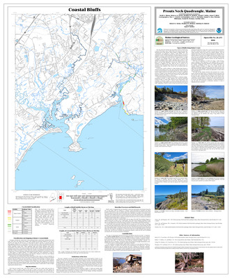
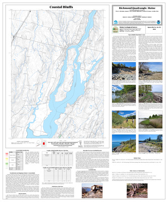
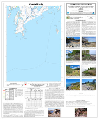
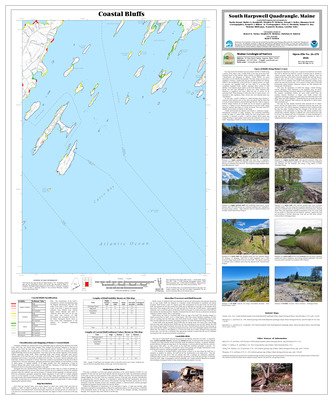
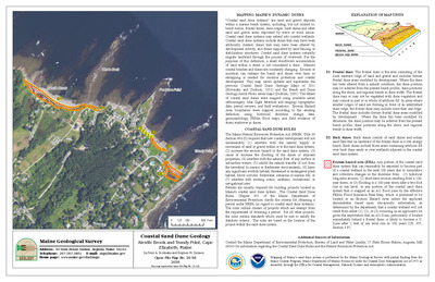
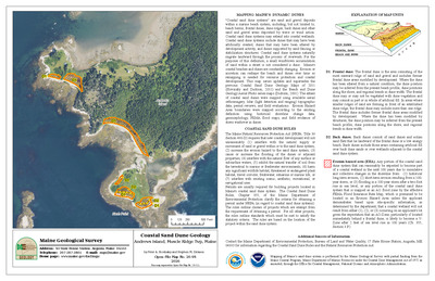
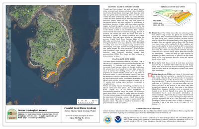
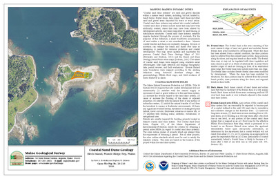
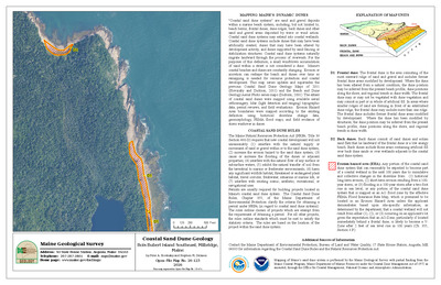
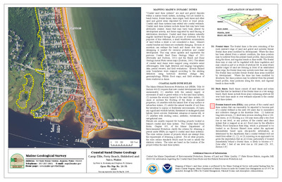
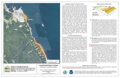
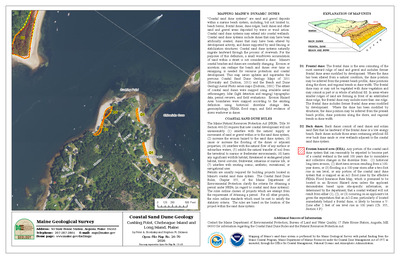
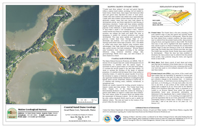
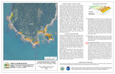
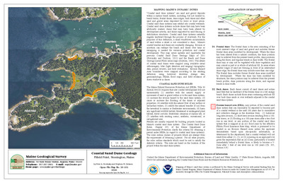
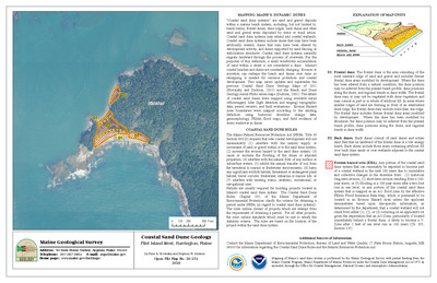
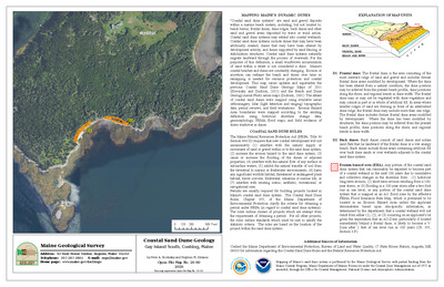
Coastal sand dune geology: Graveyard Point, Harpswell, Maine
Peter A. Slovinsky and Stephen M. Dickson
Maine Geological Survey, Open-File Map 23-153.
-

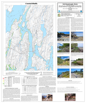
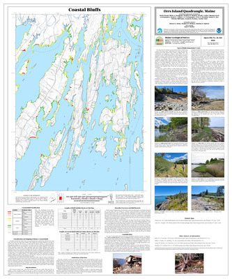
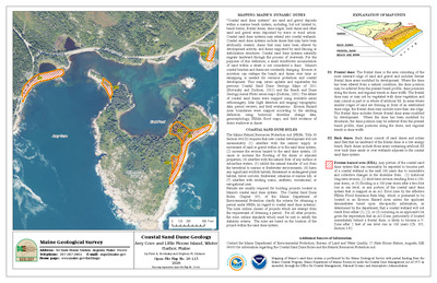
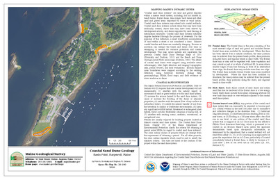
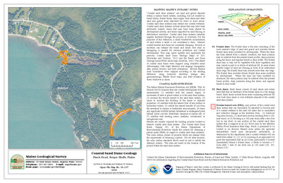
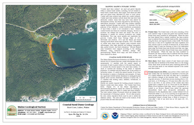
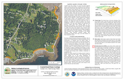
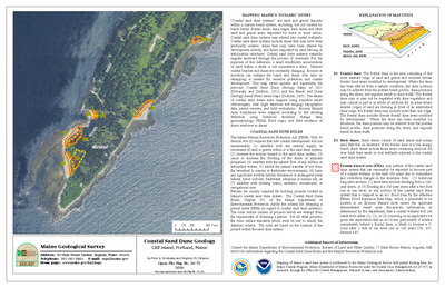
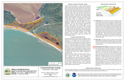
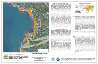
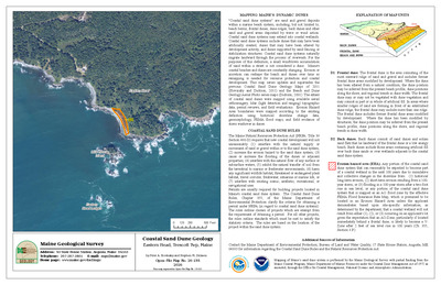
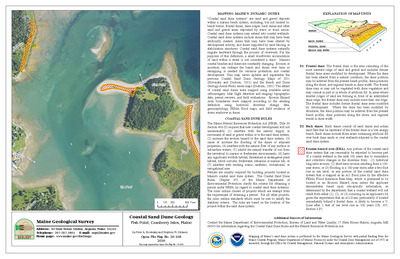
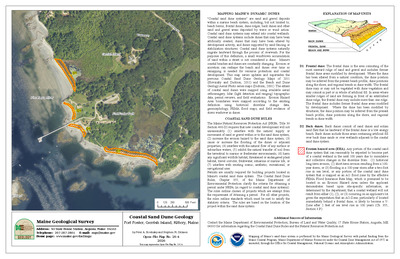
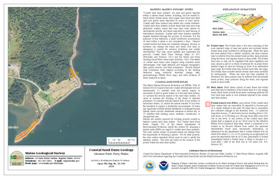
Coastal sand dune geology: Gray Cove, Deer Isle, Maine
Peter A. Slovinsky and Stephen M. Dickson
Maine Geological Survey, Open-File Map 23-330.
-

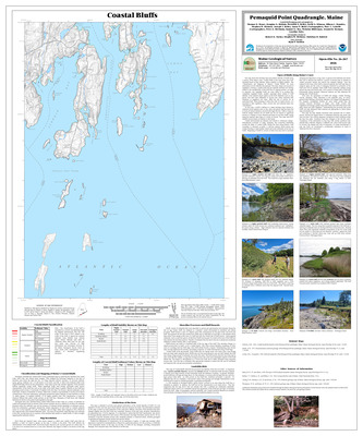
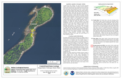
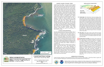
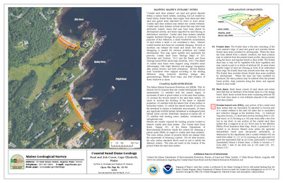
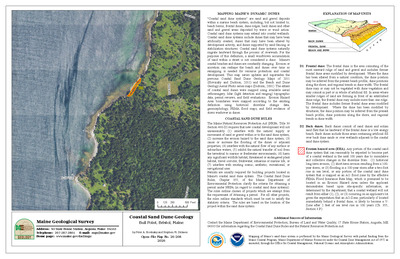
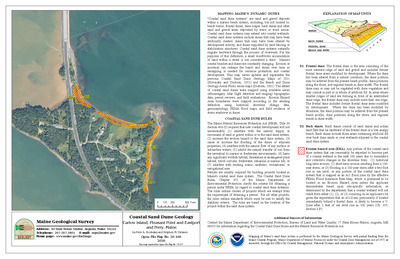
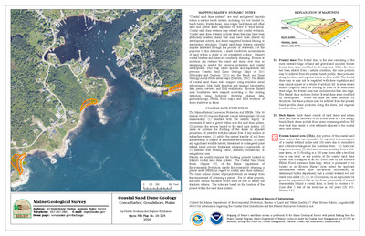
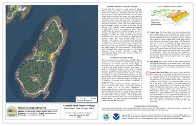
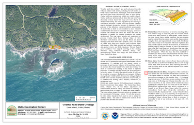
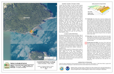
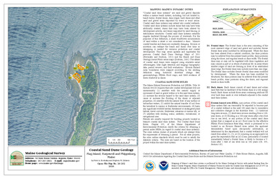
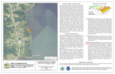
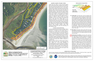
Coastal sand dune geology: Grays Beach and Bare Cove, Machiasport and Roque Bluffs, Maine
Peter A. Slovinsky and Stephen M. Dickson
Maine Geological Survey, Open-File Map 23-523 (Superseded by Slovinsky and Dickson, 2026, Maine Geological Survey Open-File Map 26-138).
-

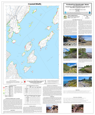
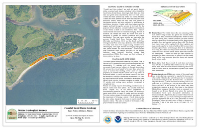
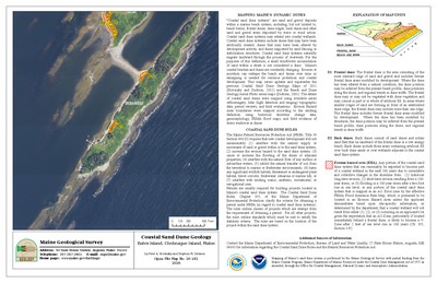
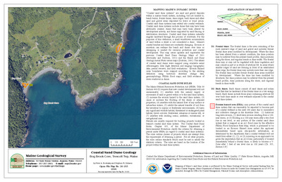
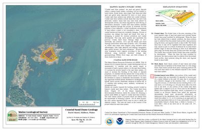
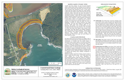
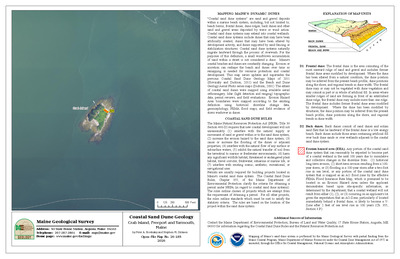
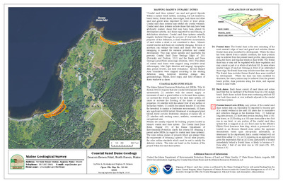
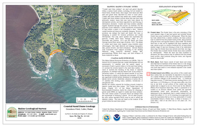
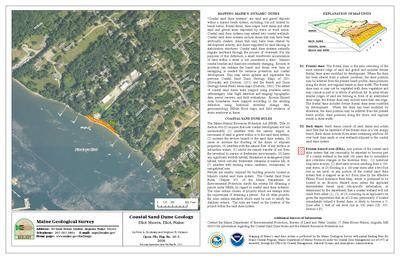
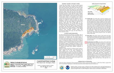
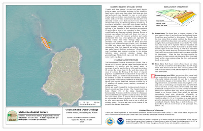
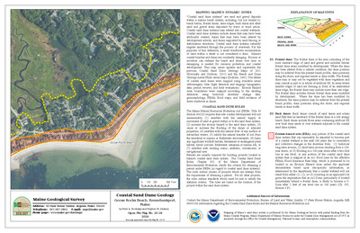
Coastal sand dune geology: Great and Little Gott Islands, Tremont, Maine
Peter A. Slovinsky and Stephen M. Dickson
Maine Geological Survey, Open-File Map 23-364.
-

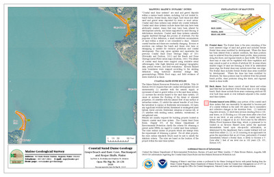
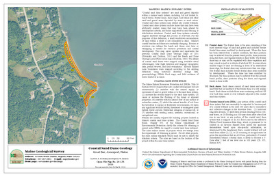
Coastal sand dune geology: Great Bar, Jonesport, Maine
Peter A. Slovinsky and Stephen M. Dickson
Maine Geological Survey, Open-File Map 23-515 (Superseded by Slovinsky and Dickson, 2026, Maine Geological Survey Open-File Map 26-135).
-

Coastal sand dune geology: Great Beach, Jonesport, Maine
Peter A. Slovinsky and Stephen M. Dickson
Maine Geological Survey, Open-File Map 23-512 (Superseded by Slovinsky and Dickson, 2026, Maine Geological Survey Open-File Map 26-134).
-

Coastal sand dune geology: Great Duck Island, Frenchboro, Maine
Peter A. Slovinsky and Stephen M. Dickson
Maine Geological Survey, Open-File Map 23-363.
-

Coastal sand dune geology: Great Gott Island, Tremont, Maine
Peter A. Slovinsky and Stephen M. Dickson
Maine Geological Survey, Open-File Map 23-365.
-

Coastal sand dune geology: Great Spoon Island, Isle au Haut, Maine
Peter A. Slovinsky and Stephen M. Dickson
Maine Geological Survey, Open-File Map 23-299.
-

Coastal sand dune geology: Green, Foley, and Goat Islands, Kennebunkport, Maine
Peter A. Slovinsky and Stephen M. Dickson
Maine Geological Survey, Open-File Map 23-67.
-

Coastal sand dune geology: Greening Island, Southwest Harbor, Maine
Peter A. Slovinsky and Stephen M. Dickson
Maine Geological Survey, Open-File Map 23-395.
-

Coastal sand dune geology: Green Island, Milbridge, Maine
Peter A. Slovinsky and Stephen M. Dickson
Maine Geological Survey, Open-File Map 23-468.
-

Coastal sand dune geology: Green Nubble, Cranberry Isles, Maine
Peter A. Slovinsky and Stephen M. Dickson
Maine Geological Survey, Open-File Map 23-413.
-

Coastal sand dune geology: Griffiths Head, Reid State Park, Georgetown, Maine
Peter A. Slovinsky and Stephen M. Dickson
Maine Geological Survey, Open-File Map 23-184.
-

Coastal sand dune geology: Grindel Point, Islesboro, Maine
Peter A. Slovinsky and Stephen M. Dickson
Maine Geological Survey, Open-File Map 23-277.
-

Coastal sand dune geology: Gull Bar, Vinalhaven, Maine
Peter A. Slovinsky and Stephen M. Dickson
Maine Geological Survey, Open-File Map 23-241.
-

Coastal sand dune geology: Gull Point, Islesboro, Maine
Peter A. Slovinsky and Stephen M. Dickson
Maine Geological Survey, Open-File Map 23-272.
-

Coastal sand dune geology: Hadley Point, Bar Harbor, Maine
Peter A. Slovinsky and Stephen M. Dickson
Maine Geological Survey, Open-File Map 23-421 (Superseded by Slovinsky and Dickson, 2026, Maine Geological Survey Open-File Map 26-110).
-

Coastal sand dune geology: Hadlock Cove, Cranberry Isles, Maine
Peter A. Slovinsky and Stephen M. Dickson
Maine Geological Survey, Open-File Map 23-417.
-

Coastal sand dune geology: Half Mile Beach, Reid State Park, Georgetown, Maine
Peter A. Slovinsky and Stephen M. Dickson
Maine Geological Survey, Open-File Map 23-182.
-

Coastal sand dune geology: Halifax Island, Jonesport, Maine
Peter A. Slovinsky and Stephen M. Dickson
Maine Geological Survey, Open-File Map 23-519.
-

Coastal sand dune geology: Harbor and Crow Islands, Frenchboro, Maine
Peter A. Slovinsky and Stephen M. Dickson
Maine Geological Survey, Open-File Map 23-361.
-

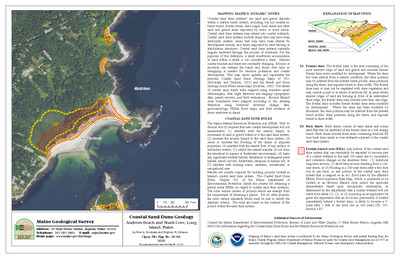
Coastal sand dune geology: Harbor Island, Friendship, Maine
Peter A. Slovinsky and Stephen M. Dickson
Maine Geological Survey, Open-File Map 23-198.
-

Coastal sand dune geology: Harbor Trail, Southwest Harbor, Maine
Peter A. Slovinsky and Stephen M. Dickson
Maine Geological Survey, Open-File Map 23-389.
-

Coastal sand dune geology: Harbor View Drive, Stockton Springs, Maine
Peter A. Slovinsky and Stephen M. Dickson
Maine Geological Survey, Open-File Map 23-292.
-

Coastal sand dune geology: Hardwood Island, Tremont, Maine
Peter A. Slovinsky and Stephen M. Dickson
Maine Geological Survey, Open-File Map 23-372.
-

Coastal sand dune geology: Harriman Point North, Brooklin, Maine
Peter A. Slovinsky and Stephen M. Dickson
Maine Geological Survey, Open-File Map 23-336.
-

Coastal sand dune geology: Harriman Point South, Brooklin, Maine
Peter A. Slovinsky and Stephen M. Dickson
Maine Geological Survey, Open-File Map 23-335.
-

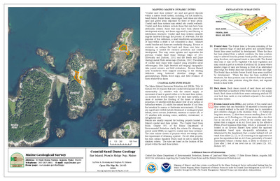
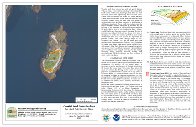
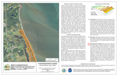
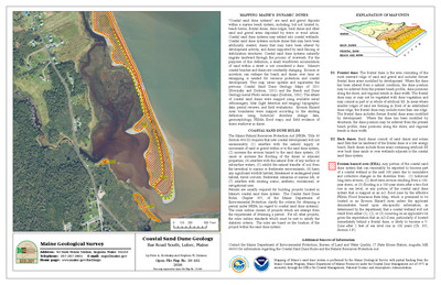
Coastal sand dune geology: Hart Island, Saint George, Maine
Peter A. Slovinsky and Stephen M. Dickson
Maine Geological Survey, Open-File Map 23-207.
-

Coastal sand dune geology: Haskell Island, Harpswell, Maine
Peter A. Slovinsky and Stephen M. Dickson
Maine Geological Survey, Open-File Map 23-150 (Superseded by Slovinsky and Dickson, 2026, Maine Geological Survey Open-File Map 26-81).
-

Coastal sand dune geology: Haven Island, North Haven, Maine
Peter A. Slovinsky and Stephen M. Dickson
Maine Geological Survey, Open-File Map 23-245.
-

Coastal sand dune geology: Haycock Harbor, Trescott Twp, Maine
Peter A. Slovinsky and Stephen M. Dickson
Maine Geological Survey, Open-File Map 23-553 (Superseded by Slovinsky and Dickson, 2026, Maine Geological Survey Open-File Map 26-156).
-

Coastal sand dune geology: Haynes Point, Trenton, Maine
Peter A. Slovinsky and Stephen M. Dickson
Maine Geological Survey, Open-File Map 23-385.
-

Coastal sand dune geology: Head Beach and Hermit Island, Phippsburg, Maine
Peter A. Slovinsky and Stephen M. Dickson
Maine Geological Survey, Open-File Map 23-167.
-

Coastal sand dune geology: Head Harbor, Isle au Haut, Maine
Peter A. Slovinsky and Stephen M. Dickson
Maine Geological Survey, Open-File Map 23-296.
-

Coastal sand dune geology: Head Harbor, Jonesport, Maine
Peter A. Slovinsky and Stephen M. Dickson
Maine Geological Survey, Open-File Map 23-500.
-

Coastal sand dune geology: Hendricks Head Beach, Southport, Maine
Peter A. Slovinsky and Stephen M. Dickson
Maine Geological Survey, Open-File Map 23-185.
-

Coastal sand dune geology: Hero Beach, Swans Island, Maine
Peter A. Slovinsky and Stephen M. Dickson
Maine Geological Survey, Open-File Map 23-350.
-

Coastal sand dune geology: Heron Island, Swans Island, Maine
Peter A. Slovinsky and Stephen M. Dickson
Maine Geological Survey, Open-File Map 23-338.
-

Coastal sand dune geology: Heron Island, Winter Harbor, Maine
Peter A. Slovinsky and Stephen M. Dickson
Maine Geological Survey, Open-File Map 23-439 (Superseded by Slovinsky and Dickson, 2026, Maine Geological Survey Open-File Map 26-112).
-

Coastal sand dune geology: Hewes Point Road, Islesboro, Maine
Peter A. Slovinsky and Stephen M. Dickson
Maine Geological Survey, Open-File Map 23-279.
-

Coastal sand dune geology: Hewett Island, Muscle Ridge Twp, Maine
Peter A. Slovinsky and Stephen M. Dickson
Maine Geological Survey, Open-File Map 23-220 (Superseded by Slovinsky and Dickson, 2026, Maine Geological Survey Open-File Map 26-94).
-

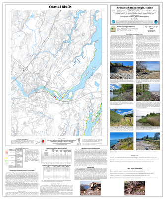
Coastal sand dune geology: Higgins Beach and Spurwink River, Cape Elizabeth and Scarborough, Maine
Peter A. Slovinsky and Stephen M. Dickson
Maine Geological Survey, Open-File Map 23-109.
-

Coastal sand dune geology: High Island Passage, South Bristol, Maine
Peter A. Slovinsky and Stephen M. Dickson
Maine Geological Survey, Open-File Map 23-191.
-

Coastal sand dune geology: Hills Beach, Biddeford, Maine
Peter A. Slovinsky and Stephen M. Dickson
Maine Geological Survey, Open-File Map 23-87 (Superseded by Slovinsky and Dickson, 2026, Maine Geological Survey Open-File Map 26-33).
-

Coastal sand dune geology: Hills Beach, Fort Hill, Biddeford, Maine
Peter A. Slovinsky and Stephen M. Dickson
Maine Geological Survey, Open-File Map 23-86 (Superseded by Slovinsky and Dickson, 2026, Maine Geological Survey Open-File Map 26-32).
-

Coastal sand dune geology: Hills Beach, Saco River, Biddeford
Peter A. Slovinsky and Stephen M. Dickson
Maine Geological Survey, Open-File Map 23-88 (Superseded by Slovinsky and Dickson, 2026, Maine Geological Survey Open-File Map 26-34).
-

Coastal sand dune geology: Hockamock Head, Swans Island, Maine
Peter A. Slovinsky and Stephen M. Dickson
Maine Geological Survey, Open-File Map 23-347.
-

Coastal sand dune geology: Hog Island and Fiddle Head, Deer Isle, Maine
Peter A. Slovinsky and Stephen M. Dickson
Maine Geological Survey, Open-File Map 23-325.
-

Coastal sand dune geology: Hog Island and Metinic Island South, Knox County Island, Maine
Peter A. Slovinsky and Stephen M. Dickson
Maine Geological Survey, Open-File Map 23-204.
-

Coastal sand dune geology: Hog Island, Gouldsboro, Maine
Peter A. Slovinsky and Stephen M. Dickson
Maine Geological Survey, Open-File Map 23-431.
-

Coastal sand dune geology: Hog Island, Machiasport, Maine
Peter A. Slovinsky and Stephen M. Dickson
Maine Geological Survey, Open-File Map 23-531 (Superseded by Slovinsky and Dickson, 2026, Maine Geological Survey Open-File Map 26-146).
-

Coastal sand dune geology: Holbrook Island, Castine, Maine
Peter A. Slovinsky and Stephen M. Dickson
Maine Geological Survey, Open-File Map 23-285.
-

Coastal sand dune geology: Holiday Beach, Owls Head, Maine
Peter A. Slovinsky and Stephen M. Dickson
Maine Geological Survey, Open-File Map 23-227.
-

Coastal sand dune geology: Hopkins Point, Surry, Maine
Peter A. Slovinsky and Stephen M. Dickson
Maine Geological Survey, Open-File Map 23-379.
-

Coastal sand dune geology: Horseshoe Cove, Biddeford, Maine
Peter A. Slovinsky and Stephen M. Dickson
Maine Geological Survey, Open-File Map 23-78.
-

Coastal sand dune geology: Hotel and Sea Glass Beaches, Southport, Maine
Peter A. Slovinsky and Stephen M. Dickson
Maine Geological Survey, Open-File Map 23-187 (Superseded by Slovinsky and Dickson, 2026, Maine Geological Survey Open-File Map 26-87).
-

Coastal sand dune geology: Howard Point, Machiasport, Maine
Peter A. Slovinsky and Stephen M. Dickson
Maine Geological Survey, Open-File Map 23-527 (Superseded by Slovinsky and Dickson, 2026, Maine Geological Survey Open-File Map 26-142).
-

Coastal sand dune geology: Hungry Island, Bremen, Maine
Peter A. Slovinsky and Stephen M. Dickson
Maine Geological Survey, Open-File Map 23-197.
-

Coastal sand dune geology: Hunnewell Beach, Phippsburg, Maine
Peter A. Slovinsky and Stephen M. Dickson
Maine Geological Survey, Open-File Map 23-175.
-

Coastal sand dune geology: Hunnewell Beach, River Beach, Phippsburg, Maine
Peter A. Slovinsky and Stephen M. Dickson
Maine Geological Survey, Open-File Map 23-176.
-

Coastal sand dune geology: Hunters Beach, Mount Desert, Maine
Peter A. Slovinsky and Stephen M. Dickson
Maine Geological Survey, Open-File Map 23-401.
-

Coastal sand dune geology: Hupper Island, Saint George, Maine
Peter A. Slovinsky and Stephen M. Dickson
Maine Geological Survey, Open-File Map 23-208.
-

Coastal sand dune geology: Indian Island, Bristol, Maine
Peter A. Slovinsky and Stephen M. Dickson
Maine Geological Survey, Open-File Map 23-195.
-

Coastal sand dune geology: Indian Point, Chebeague Island, Maine
Peter A. Slovinsky and Stephen M. Dickson
Maine Geological Survey, Open-File Map 23-137 (Superseded by Slovinsky and Dickson, 2026, Maine Geological Survey Open-File Map 26-73).
-

Coastal sand dune geology: Indian Point North, Georgetown, Maine
Peter A. Slovinsky and Stephen M. Dickson
Maine Geological Survey, Open-File Map 23-180.
-

Coastal sand dune geology: Indian Point South, Georgetown, Maine
Peter A. Slovinsky and Stephen M. Dickson
Maine Geological Survey, Open-File Map 23-179.
-

Coastal sand dune geology: Ingersoll Point, Addison, Maine
Peter A. Slovinsky and Stephen M. Dickson
Maine Geological Survey, Open-File Map 23-488 (Superseded by Slovinsky and Dickson, 2026, Maine Geological Survey Open-File Map 26-124).
-

Coastal sand dune geology: Intervale Road, Harpswell, Maine
Peter A. Slovinsky and Stephen M. Dickson
Maine Geological Survey, Open-File Map 23-154.
-

Coastal sand dune geology: Irish Point, Swans Island, Maine
Peter A. Slovinsky and Stephen M. Dickson
Maine Geological Survey, Open-File Map 23-343.
-

Coastal sand dune geology: Ironbound Island Northwest, Winter Harbor, Maine
Peter A. Slovinsky and Stephen M. Dickson
Maine Geological Survey, Open-File Map 23-434.
-

Coastal sand dune geology: Jaquish Gut, Harpswell, Maine
Peter A. Slovinsky and Stephen M. Dickson
Maine Geological Survey, Open-File Map 23-151 (Superseded by Slovinsky and Dickson, 2026, Maine Geological Survey Open-File Map 26-82).
-

Coastal sand dune geology: Jasper Beach, Machiasport, Maine
Peter A. Slovinsky and Stephen M. Dickson
Maine Geological Survey, Open-File Map 23-528 (Superseded by Slovinsky and Dickson, 2026, Maine Geological Survey Open-File Map 26-143).
-

Coastal sand dune geology: Jed Island, Blue Hill, Maine
Peter A. Slovinsky and Stephen M. Dickson
Maine Geological Survey, Open-File Map 23-377.
-

Coastal sand dune geology: Jetty Road, Searsport, Maine
Peter A. Slovinsky and Stephen M. Dickson
Maine Geological Survey, Open-File Map 23-289.
-

Coastal sand dune geology: Jims Point, Blue Hill, Maine
Peter A. Slovinsky and Stephen M. Dickson
Maine Geological Survey, Open-File Map 23-374.
-

Coastal sand dune geology: Johnson Cove, Chebeague Island, Maine
Peter A. Slovinsky and Stephen M. Dickson
Maine Geological Survey, Open-File Map 23-139 (Superseded by Slovinsky and Dickson, 2024, Maine Geological Survey Open-File 24-4).
-

Coastal sand dune geology: Johnson Cove, Eastport, Maine
Peter A. Slovinsky and Stephen M. Dickson
Maine Geological Survey, Open-File Map 23-574.
-

Coastal sand dune geology: Joyce Beach, Swans Island, Maine
Peter A. Slovinsky and Stephen M. Dickson
Maine Geological Survey, Open-File Map 23-352.
-

Coastal sand dune geology: Kelley Point, Jonesport, Maine
Peter A. Slovinsky and Stephen M. Dickson
Maine Geological Survey, Open-File Map 23-505 (Superseded by Slovinsky and Dickson, 2026, Maine Geological Survey Open-File Map 26-128).
-

Coastal sand dune geology: Kelley School, Jonesport, Maine
Peter A. Slovinsky and Stephen M. Dickson
Maine Geological Survey, Open-File Map 23-504 (Superseded by Slovinsky and Dickson, 2026, Maine Geological Survey Open-File Map 26-127).
-

Coastal sand dune geology: Kennebec and Bay Points, Georgetown, Maine
Peter A. Slovinsky and Stephen M. Dickson
Maine Geological Survey, Open-File Map 23-178.
-

Coastal sand dune geology: Kennedy Beach and Fishermans Cove, Portland, Maine
Peter A. Slovinsky and Stephen M. Dickson
Maine Geological Survey, Open-File Map 23-135.
-

Coastal sand dune geology: Kings Point South, Southwest Harbor, Maine
Peter A. Slovinsky and Stephen M. Dickson
Maine Geological Survey, Open-File Map 23-392.
-

Coastal sand dune geology: Kings Point, Southwest Harbor, Maine
Peter A. Slovinsky and Stephen M. Dickson
Maine Geological Survey, Open-File Map 23-393 (Superseded by Slovinsky and Dickson, 2026, Maine Geological Survey Open-File Map 26-104).
-

Coastal sand dune geology: Kinney Shores and Ocean Park, Saco and Old Orchard Beach, Maine
Peter A. Slovinsky and Stephen M. Dickson
Maine Geological Survey, Open-File Map 23-93 (Superseded by Slovinsky and Dickson, 2026, Maine Geological Survey Open-File Map 26-39).
-

Coastal sand dune geology: Kinney Shores, Bay View, Saco, Maine
Peter A. Slovinsky and Stephen M. Dickson
Maine Geological Survey, Open-File Map 23-92 (Superseded by Slovinsky and Dickson, 2026, Maine Geological Survey Open-File Map 26-38).
-

Coastal sand dune geology: Lakeman and Bar Islands, Jonesport, Maine
Peter A. Slovinsky and Stephen M. Dickson
Maine Geological Survey, Open-File Map 23-518.
-

Coastal sand dune geology: Lakeman Harbor and Marsh Island, Jonesport, Maine
Peter A. Slovinsky and Stephen M. Dickson
Maine Geological Survey, Open-File Map 23-517.
-

Coastal sand dune geology: Lamoine Beach Park, Lamoine, Maine
Peter A. Slovinsky and Stephen M. Dickson
Maine Geological Survey, Open-File Map 23-423.
-

Coastal sand dune geology: Lamson Cove, Great Diamond Island, Portland, Maine
Peter A. Slovinsky and Stephen M. Dickson
Maine Geological Survey, Open-File Map 23-126 (Superseded by Slovinsky and Dickson, 2026, Maine Geological Survey Open-File Map 26-65).
-

Coastal sand dune geology: Lanes Island Preserve, Vinalhaven, Maine
Peter A. Slovinsky and Stephen M. Dickson
Maine Geological Survey, Open-File Map 23-235.
-

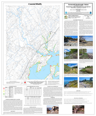
Coastal sand dune geology: Lanes Island, Yarmouth, Maine
Peter A. Slovinsky and Stephen M. Dickson
Maine Geological Survey, Open-File Map 23-147.
-

Coastal sand dune geology: Lasell and Lime Islands, Islesboro and North Haven, Maine
Peter A. Slovinsky and Stephen M. Dickson
Maine Geological Survey, Open-File Map 23-262.
-

Coastal sand dune geology: Leadbetter Narrows, Vinalhaven, Maine
Peter A. Slovinsky and Stephen M. Dickson
Maine Geological Survey, Open-File Map 23-233.
-

Coastal sand dune geology: Leighton Point, Pembroke, Maine
Peter A. Slovinsky and Stephen M. Dickson
Maine Geological Survey, Open-File Map 23-569.
-

Coastal sand dune geology: Liberty Point, Robbinston, Maine
Peter A. Slovinsky and Stephen M. Dickson
Maine Geological Survey, Open-File Map 23-582.
-

Coastal sand dune geology: Lily Pond, Biddeford, Maine
Peter A. Slovinsky and Stephen M. Dickson
Maine Geological Survey, Open-File Map 23-79.
-

Coastal sand dune geology: Lincolnville Beach, Lincolnville, Maine
Peter A. Slovinsky and Stephen M. Dickson
Maine Geological Survey, Open-File Map 23-266 (Superseded by Slovinsky and Dickson, 2026, Maine Geological Survey Open-File Map 26-99).
-

Coastal sand dune geology: Little Bois Bubert Island, Milbridge, Maine
Peter A. Slovinsky and Stephen M. Dickson
Maine Geological Survey, Open-File Map 23-469.
-

Coastal sand dune geology: Little Cape Point, Beals, Maine
Peter A. Slovinsky and Stephen M. Dickson
Maine Geological Survey, Open-File Map 23-498 (Superseded by Slovinsky and Dickson, 2026, Maine Geological Survey Open-File Map 26-126).
-

Coastal sand dune geology: Little Chebeague Island, Chebeague Island and Long Island, Maine
Peter A. Slovinsky and Stephen M. Dickson
Maine Geological Survey, Open-File Map 23-133 (Superseded by Slovinsky and Dickson, 2026, Maine Geological Survey Open-File Map 26-71).
-

Coastal sand dune geology: Little Green Island, North Haven, Maine
Peter A. Slovinsky and Stephen M. Dickson
Maine Geological Survey, Open-File Map 23-254.
-

Coastal sand dune geology: Little Harbor Brook, Mount Desert, Maine
Peter A. Slovinsky and Stephen M. Dickson
Maine Geological Survey, Open-File Map 23-398.
-

Coastal sand dune geology: Little Head, Cranberry Isles, Maine
Peter A. Slovinsky and Stephen M. Dickson
Maine Geological Survey, Open-File Map 23-406.
-

Coastal sand dune geology: Little Island, Matinicus Isle Plt, Maine
Peter A. Slovinsky and Stephen M. Dickson
Maine Geological Survey, Open-File Map 23-232.
-

Coastal sand dune geology: Little Machias Bay Northwest 1, Cutler, Maine
Peter A. Slovinsky and Stephen M. Dickson
Maine Geological Survey, Open-File Map 23-544.
-

Coastal sand dune geology: Little Machias Bay Northwest 2, Cutler, Maine
Peter A. Slovinsky and Stephen M. Dickson
Maine Geological Survey, Open-File Map 23-545.
-

Coastal sand dune geology: Little Pond Beach, Jonesport, Maine
Peter A. Slovinsky and Stephen M. Dickson
Maine Geological Survey, Open-File Map 23-507 (Superseded by Slovinsky and Dickson, 2026, Maine Geological Survey Open-File Map 26-130).
-

Coastal sand dune geology: Little Ram Island, Beals, Maine
Peter A. Slovinsky and Stephen M. Dickson
Maine Geological Survey, Open-File Map 23-493.
-

Coastal sand dune geology: Little River, Cutler, Maine
Peter A. Slovinsky and Stephen M. Dickson
Maine Geological Survey, Open-File Map 23-547.
-

Coastal sand dune geology: Lobster Cove, Steuben, Maine
Peter A. Slovinsky and Stephen M. Dickson
Maine Geological Survey, Open-File Map 23-456.
-

Coastal sand dune geology: Lobster Cove, York, Maine
Peter A. Slovinsky and Stephen M. Dickson
Maine Geological Survey, Open-File Map 23-35 (Superseded by Slovinsky and Dickson, 2026, Maine Geological Survey Open-File Map 26-8).
-

Coastal sand dune geology: Long Beach, Central, York, Maine
Peter A. Slovinsky and Stephen M. Dickson
Maine Geological Survey, Open-File Map 23-37 (Superseded by Slovinsky and Dickson, 2026, Maine Geological Survey Open-File Map 26-10).
-

Coastal sand dune geology: Long Beach, North, York, Maine
Peter A. Slovinsky and Stephen M. Dickson
Maine Geological Survey, Open-File Map 23-38 (Superseded by Slovinsky and Dickson, 2026, Maine Geological Survey Open-File Map 26-11).
-

Coastal sand dune geology: Long Beach, South, York, Maine
Peter A. Slovinsky and Stephen M. Dickson
Maine Geological Survey, Open-File Map 23-36 (Superseded by Slovinsky and Dickson, 2026, Maine Geological Survey Open-File Map 26-9).
-

Coastal sand dune geology: Long Island North, Blue Hill, Maine
Peter A. Slovinsky and Stephen M. Dickson
Maine Geological Survey, Open-File Map 23-376.
-

Coastal sand dune geology: Long Point and Long Point Island, Harpswell, Maine
Peter A. Slovinsky and Stephen M. Dickson
Maine Geological Survey, Open-File Map 23-160 (Superseded by Slovinsky and Dickson, 2026, Maine Geological Survey Open-File Map 26-84).
-

Coastal sand dune geology: Long Point, Cranberry Isles, Maine
Peter A. Slovinsky and Stephen M. Dickson
Maine Geological Survey, Open-File Map 23-405 (Superseded by Slovinsky and Dickson, 2026, Maine Geological Survey Open-File Map 26-106).
-

Coastal sand dune geology: Long Point, Cranberry Isles, Maine
Peter A. Slovinsky and Stephen M. Dickson
Maine Geological Survey, Open-File Map 23-408 (Superseded by Slovinsky and Dickson, 2026, Maine Geological Survey Open-File Map 26-107).
-

Coastal sand dune geology: Long Point Preserve, Machiasport, Maine
Peter A. Slovinsky and Stephen M. Dickson
Maine Geological Survey, Open-File Map 23-530 (Superseded by Slovinsky and Dickson, 2026, Maine Geological Survey Open-File Map 26-145).
-

Coastal sand dune geology: Long Point, Swans Island, Maine
Peter A. Slovinsky and Stephen M. Dickson
Maine Geological Survey, Open-File Map 23-342.
-

Coastal sand dune geology: Loon and Rhine Points, Jonesport, Maine
Peter A. Slovinsky and Stephen M. Dickson
Maine Geological Survey, Open-File Map 23-506 (Superseded by Slovinsky and Dickson, 2026, Maine Geological Survey Open-File Map 26-129).
-

Coastal sand dune geology: Lords Point, Libbys Point, Kennebunk, Maine
Peter A. Slovinsky and Stephen M. Dickson
Maine Geological Survey, Open-File Map 23-60 (Superseded by Slovinsky and Dickson, 2026, Maine Geological Survey Open-File Map 26-24).
-

Coastal sand dune geology: Loring Cove, Perry, Maine
Peter A. Slovinsky and Stephen M. Dickson
Maine Geological Survey, Open-File Map 23-581.
-

Coastal sand dune geology: Louds Island North, Bristol, Maine
Peter A. Slovinsky and Stephen M. Dickson
Maine Geological Survey, Open-File Map 23-196 (Superseded by Slovinsky and Dickson, 2026, Maine Geological Survey Open-File Map 26-89).
-

Coastal sand dune geology: Loudville, Bristol, Maine
Peter A. Slovinsky and Stephen M. Dickson
Maine Geological Survey, Open-File Map 23-194.
-

Coastal sand dune geology: Lower Head, Swans Island, Maine
Peter A. Slovinsky and Stephen M. Dickson
Maine Geological Survey, Open-File Map 23-339.
-

Coastal sand dune geology: Lower Torrey Island, Brooklin, Maine
Peter A. Slovinsky and Stephen M. Dickson
Maine Geological Survey, Open-File Map 23-333.
-

Coastal sand dune geology: Mackerel Cove, Harpswell, Maine
Peter A. Slovinsky and Stephen M. Dickson
Maine Geological Survey, Open-File Map 23-152 (Superseded by Slovinsky and Dickson, 2026, Maine Geological Survey Open-File Map 26-83).
-

Coastal sand dune geology: Main Beach, Ram Island, Cape Elizabeth, Maine
Peter A. Slovinsky and Stephen M. Dickson
Maine Geological Survey, Open-File Map 23-110 (Superseded by Slovinsky and Dickson, 2026, Maine Geological Survey Open-File Map 26-53).
-

Coastal sand dune geology: Marlboro Beach, Lamoine, Maine
Peter A. Slovinsky and Stephen M. Dickson
Maine Geological Survey, Open-File Map 23-425.
-

Coastal sand dune geology: Marshall Point, Kennebunkport, Maine
Peter A. Slovinsky and Stephen M. Dickson
Maine Geological Survey, Open-File Map 23-70.
-

Coastal sand dune geology: Marsh Cove, North Haven, Maine
Peter A. Slovinsky and Stephen M. Dickson
Maine Geological Survey, Open-File Map 23-258.
-

Coastal sand dune geology: Marsh Head and Bar Point, Cranberry Isles, Maine
Peter A. Slovinsky and Stephen M. Dickson
Maine Geological Survey, Open-File Map 23-414 (Superseded by Slovinsky and Dickson, 2026, Maine Geological Survey Open-File Map 26-109).
-

Coastal sand dune geology: Mary Look Point, Addison, Maine
Peter A. Slovinsky and Stephen M. Dickson
Maine Geological Survey, Open-File Map 23-487.
-

Coastal sand dune geology: Matthews Island, Eastport, Maine
Peter A. Slovinsky and Stephen M. Dickson
Maine Geological Survey, Open-File Map 23-572.
-

Coastal sand dune geology: Maxwell Point, Staples Cove, and Dyer Cove, Cape Elizabeth, Maine
Peter A. Slovinsky and Stephen M. Dickson
Maine Geological Survey, Open-File Map 23-115 (Superseded by Slovinsky and Dickson, 2024, Maine Geological Survey Open-File 24-3).
-

Coastal sand dune geology: Meadow Point, Lamoine, Maine
Peter A. Slovinsky and Stephen M. Dickson
Maine Geological Survey, Open-File Map 23-424.
-

Coastal sand dune geology: Merchant Island, Isle au Haut, Maine
Peter A. Slovinsky and Stephen M. Dickson
Maine Geological Survey, Open-File Map 23-303.
-

Coastal sand dune geology: Merchants Cove, Isle au Haut, Maine
Peter A. Slovinsky and Stephen M. Dickson
Maine Geological Survey, Open-File Map 23-297.
-

Coastal sand dune geology: Metinic Island Central, Knox County Island, Maine
Peter A. Slovinsky and Stephen M. Dickson
Maine Geological Survey, Open-File Map 23-205.
-

Coastal sand dune geology: Metinic Island North, Knox County Island, Maine
Peter A. Slovinsky and Stephen M. Dickson
Maine Geological Survey, Open-File Map 23-206.
-

Coastal sand dune geology: Middle Beach, Mothers Beach, Kennebunk, Maine
Peter A. Slovinsky and Stephen M. Dickson
Maine Geological Survey, Open-File Map 23-61 (Superseded by Slovinsky and Dickson, 2026, Maine Geological Survey Open-File Map 26-25).
-

Coastal sand dune geology: Middle Island, Islesboro, Maine
Peter A. Slovinsky and Stephen M. Dickson
Maine Geological Survey, Open-File Map 23-271.
-

Coastal sand dune geology: Mile Beach, Reid State Park, Georgetown, Maine
Peter A. Slovinsky and Stephen M. Dickson
Maine Geological Survey, Open-File Map 23-183.
-

Coastal sand dune geology: Mile Stretch Beach, South Point, Biddeford, Maine
Peter A. Slovinsky and Stephen M. Dickson
Maine Geological Survey, Open-File Map 23-83.
-

Coastal sand dune geology: Mile Stretch Beach, The Pool, Biddeford, Maine
Peter A. Slovinsky and Stephen M. Dickson
Maine Geological Survey, Open-File Map 23-82.
-

Coastal sand dune geology: Mill Point, Phippsburg, Maine
Peter A. Slovinsky and Stephen M. Dickson
Maine Geological Survey, Open-File Map 23-166.
-

Coastal sand dune geology: Ministerial Island, Chebeague Island, Maine
Peter A. Slovinsky and Stephen M. Dickson
Maine Geological Survey, Open-File Map 23-142 (Superseded by Slovinsky and Dickson, 2026, Maine Geological Survey Open-File Map 26-76).
-

Coastal sand dune geology: Money and Almore Coves, Cutler, Maine
Peter A. Slovinsky and Stephen M. Dickson
Maine Geological Survey, Open-File Map 23-549.
-

Coastal sand dune geology: Monhonan Cove, Milbridge, Maine
Peter A. Slovinsky and Stephen M. Dickson
Maine Geological Survey, Open-File Map 23-474.
-

Coastal sand dune geology: Monroe Island, Owls Head, Maine
Peter A. Slovinsky and Stephen M. Dickson
Maine Geological Survey, Open-File Map 23-228.
-

Coastal sand dune geology: Moody Beach, North, Wells, Maine
Peter A. Slovinsky and Stephen M. Dickson
Maine Geological Survey, Open-File Map 23-49 (Superseded by Slovinsky and Dickson, 2026, Maine Geological Survey Open-File Map 26-18).
-

Coastal sand dune geology: Moody Beach, South, Wells, Maine
Peter A. Slovinsky and Stephen M. Dickson
Maine Geological Survey, Open-File Map 23-48 (Superseded by Slovinsky and Dickson, 2026, Maine Geological Survey Open-File Map 26-17).
-

Coastal sand dune geology: Moody Point, Fishermans Cove, Wells, Maine
Peter A. Slovinsky and Stephen M. Dickson
Maine Geological Survey, Open-File Map 23-50 (Superseded by Slovinsky and Dickson, 2026, Maine Geological Survey Open-File Map 26-19).
-

Coastal sand dune geology: Moose Cove, Trescott Twp, Maine
Peter A. Slovinsky and Stephen M. Dickson
Maine Geological Survey, Open-File Map 23-551 (Superseded by Slovinsky and Dickson, 2026, Maine Geological Survey Open-File Map 26-154).
-

Coastal sand dune geology: Moose Island, Tremont, Maine
Peter A. Slovinsky and Stephen M. Dickson
Maine Geological Survey, Open-File Map 23-371.
-

Coastal sand dune geology: Moose Ledge, Jonesport, Maine
Peter A. Slovinsky and Stephen M. Dickson
Maine Geological Survey, Open-File Map 23-501.
-

Coastal sand dune geology: Moose Neck, Addison, Maine
Peter A. Slovinsky and Stephen M. Dickson
Maine Geological Survey, Open-File Map 23-489 (Superseded by Slovinsky and Dickson, 2026, Maine Geological Survey Open-File Map 26-125).
-

Coastal sand dune geology: Morgan Bay, Surry, Maine
Peter A. Slovinsky and Stephen M. Dickson
Maine Geological Survey, Open-File Map 23-380.
-

Coastal sand dune geology: Morse Island, Friendship, Maine
Peter A. Slovinsky and Stephen M. Dickson
Maine Geological Survey, Open-File Map 23-201.
-

Coastal sand dune geology: Mosquito Head, Saint George, Maine
Peter A. Slovinsky and Stephen M. Dickson
Maine Geological Survey, Open-File Map 23-213.
-

Coastal sand dune geology: Mosquito Island East, Saint George, Maine
Peter A. Slovinsky and Stephen M. Dickson
Maine Geological Survey, Open-File Map 23-210.
-

Coastal sand dune geology: Mosquito Island West, Saint George, Maine
Peter A. Slovinsky and Stephen M. Dickson
Maine Geological Survey, Open-File Map 23-209.
-

Coastal sand dune geology: Mullen Cove, North Haven, Maine
Peter A. Slovinsky and Stephen M. Dickson
Maine Geological Survey, Open-File Map 23-256.
-

Coastal sand dune geology: Mullen Head Park and Banks Cove, North Haven, Maine
Peter A. Slovinsky and Stephen M. Dickson
Maine Geological Survey, Open-File Map 23-257.
-

Coastal sand dune geology: Narrows Island, Harrington, Maine
Peter A. Slovinsky and Stephen M. Dickson
Maine Geological Survey, Open-File Map 23-481.
-

Coastal sand dune geology: Nash and Big Nash Islands, Addison, Maine
Peter A. Slovinsky and Stephen M. Dickson
Maine Geological Survey, Open-File Map 23-490.
-

Coastal sand dune geology: Neck Island, Vinalhaven, Maine
Peter A. Slovinsky and Stephen M. Dickson
Maine Geological Survey, Open-File Map 23-240.
-

Coastal sand dune geology: Nessler Point, Kennebunkport, Maine
Peter A. Slovinsky and Stephen M. Dickson
Maine Geological Survey, Open-File Map 23-69.
-

Coastal sand dune geology: North Creek, Phippsburg, Maine
Peter A. Slovinsky and Stephen M. Dickson
Maine Geological Survey, Open-File Map 23-164.
-

Coastal sand dune geology: North Deer Isle, Deer Isle, Maine
Peter A. Slovinsky and Stephen M. Dickson
Maine Geological Survey, Open-File Map 23-329.
-

Coastal sand dune geology: North Lubec Road, Lubec, Maine
Peter A. Slovinsky and Stephen M. Dickson
Maine Geological Survey, Open-File Map 23-567 (Superseded by Slovinsky and Dickson, 2026, Maine Geological Survey Open-File Map 26-165).
-

Coastal sand dune geology: Northwest Harbor, Cutler, Maine
Peter A. Slovinsky and Stephen M. Dickson
Maine Geological Survey, Open-File Map 23-537.
-

Coastal sand dune geology: Norton Island, Addison, Maine
Peter A. Slovinsky and Stephen M. Dickson
Maine Geological Survey, Open-File Map 23-483.
-

Coastal sand dune geology: Norton Island, Saint George, Maine
Peter A. Slovinsky and Stephen M. Dickson
Maine Geological Survey, Open-File Map 23-217.
-

Coastal sand dune geology: Norwood Road, Eastport, Maine
Peter A. Slovinsky and Stephen M. Dickson
Maine Geological Survey, Open-File Map 23-573.
-

Coastal sand dune geology: Oak Hill and Burnt Island, North Haven, Maine
Peter A. Slovinsky and Stephen M. Dickson
Maine Geological Survey, Open-File Map 23-260.
-

Coastal sand dune geology: Oak Island, North Haven, Maine
Peter A. Slovinsky and Stephen M. Dickson
Maine Geological Survey, Open-File Map 23-261.
-

Coastal sand dune geology: Oarweed Cove, Ogunquit, Maine
Peter A. Slovinsky and Stephen M. Dickson
Maine Geological Survey, Open-File Map 23-44 (Superseded by Slovinsky and Dickson, 2026, Maine Geological Survey Open-File Map 26-13).
-

Coastal sand dune geology: Ocean Avenue, Biddeford, Maine
Peter A. Slovinsky and Stephen M. Dickson
Maine Geological Survey, Open-File Map 23-84.
-

Coastal sand dune geology: Ogunquit Beach, Central, Ogunquit, Maine
Peter A. Slovinsky and Stephen M. Dickson
Maine Geological Survey, Open-File Map 23-46 (Superseded by Slovinsky and Dickson, 2026, Maine Geological Survey Open-File Map 26-15).
-

Coastal sand dune geology: Ogunquit Beach, North, Ogunquit and Wells, Maine
Peter A. Slovinsky and Stephen M. Dickson
Maine Geological Survey, Open-File Map 23-47 (Superseded by Slovinsky and Dickson, 2026, Maine Geological Survey Open-File Map 26-16).
-

Coastal sand dune geology: Ogunquit Beach, South, Ogunquit, Maine
Peter A. Slovinsky and Stephen M. Dickson
Maine Geological Survey, Open-File Map 23-45 (Superseded by Slovinsky and Dickson, 2026, Maine Geological Survey Open-File Map 26-14).
-

Coastal sand dune geology: Old Orchard Beach, East Grand Avenue, Old Orchard Beach, Maine
Peter A. Slovinsky and Stephen M. Dickson
Maine Geological Survey, Open-File Map 23-96 (Superseded by Slovinsky and Dickson, 2026, Maine Geological Survey Open-File Map 26-42).
-

Coastal sand dune geology: Old Orchard Beach, West Grand Avenue, Old Orchard Beach, Maine
Peter A. Slovinsky and Stephen M. Dickson
Maine Geological Survey, Open-File Map 23-94 (Superseded by Slovinsky and Dickson, 2026, Maine Geological Survey Open-File Map 26-40).
-

Coastal sand dune geology: Opechee Island Northwest, Swans Island, Maine
Peter A. Slovinsky and Stephen M. Dickson
Maine Geological Survey, Open-File Map 23-355.
-

Coastal sand dune geology: Opechee Island Southeast, Swans Island, Maine
Peter A. Slovinsky and Stephen M. Dickson
Maine Geological Survey, Open-File Map 23-354.
-

Coastal sand dune geology: Orchard Beach, Deer Isle, Maine
Peter A. Slovinsky and Stephen M. Dickson
Maine Geological Survey, Open-File Map 23-320.
-

Coastal sand dune geology: Otter Cove, Bar Harbor and Mount Desert, Maine
Peter A. Slovinsky and Stephen M. Dickson
Maine Geological Survey, Open-File Map 23-402.
-

Coastal sand dune geology: Otter Ponds, Swans Island, Maine
Peter A. Slovinsky and Stephen M. Dickson
Maine Geological Survey, Open-File Map 23-351.
-

Coastal sand dune geology: Over Point, Steuben, Maine
Peter A. Slovinsky and Stephen M. Dickson
Maine Geological Survey, Open-File Map 23-460.
-

Coastal sand dune geology: Owls Head Harbor, Owls Head, Maine
Peter A. Slovinsky and Stephen M. Dickson
Maine Geological Survey, Open-File Map 23-229 (Superseded by Slovinsky and Dickson, 2026, Maine Geological Survey Open-File Map 26-97).
-

Coastal sand dune geology: Parsons Beach, Great Hill, Kennebunk, Maine
Peter A. Slovinsky and Stephen M. Dickson
Maine Geological Survey, Open-File Map 23-59 (Superseded by Slovinsky and Dickson, 2026, Maine Geological Survey Open-File Map 26-23).
-

Coastal sand dune geology: Parsons Beach, Kennebunk, Maine
Peter A. Slovinsky and Stephen M. Dickson
Maine Geological Survey, Open-File Map 23-58.
-

Coastal sand dune geology: Pattison Road, Lincolnville, Maine
Peter A. Slovinsky and Stephen M. Dickson
Maine Geological Survey, Open-File Map 23-267.
-

Coastal sand dune geology: Peak Island, The Sugarload, and Butler Island, Deer Isle, Maine
Peter A. Slovinsky and Stephen M. Dickson
Maine Geological Survey, Open-File Map 23-319.
-

Coastal sand dune geology: Pemaquid Beach, Fish Point, Bristol, Maine
Peter A. Slovinsky and Stephen M. Dickson
Maine Geological Survey, Open-File Map 23-192 (Superseded by Slovinsky and Dickson, 2026, Maine Geological Survey Open-File Map 26-88).
-

Coastal sand dune geology: Perkins Point, Castine, Maine
Peter A. Slovinsky and Stephen M. Dickson
Maine Geological Survey, Open-File Map 23-287.
-

Coastal sand dune geology: Petit Manan Point Northwest, Steuben, Maine
Peter A. Slovinsky and Stephen M. Dickson
Maine Geological Survey, Open-File Map 23-462.
-

Coastal sand dune geology: Petit Manan Point, Steuben, Maine
Peter A. Slovinsky and Stephen M. Dickson
Maine Geological Survey, Open-File Map 23-463.
-

Coastal sand dune geology: Philbrook Cove, Islesboro, Maine
Peter A. Slovinsky and Stephen M. Dickson
Maine Geological Survey, Open-File Map 23-275.
-

Coastal sand dune geology: Phillips Cove, York, Maine
Peter A. Slovinsky and Stephen M. Dickson
Maine Geological Survey, Open-File Map 23-43.
-

Coastal sand dune geology: Pickering Island and Eastern Cove, Deer Isle, Maine
Peter A. Slovinsky and Stephen M. Dickson
Maine Geological Survey, Open-File Map 23-327.
-

Coastal sand dune geology: Pickering Island and Western Cove, Deer Isle, Maine
Peter A. Slovinsky and Stephen M. Dickson
Maine Geological Survey, Open-File Map 23-326.
-

Coastal sand dune geology: Pier Road, Perry, Maine
Peter A. Slovinsky and Stephen M. Dickson
Maine Geological Survey, Open-File Map 23-578 (Superseded by Slovinsky and Dickson, 2026, Maine Geological Survey Open-File Map 26-167).
-

Coastal sand dune geology: Pigeon Hill, Steuben, Maine
Peter A. Slovinsky and Stephen M. Dickson
Maine Geological Survey, Open-File Map 23-467.
-

Coastal sand dune geology: Pine Point Beach, Scarborough, Maine
Peter A. Slovinsky and Stephen M. Dickson
Maine Geological Survey, Open-File Map 23-99 (Superseded by Slovinsky and Dickson, 2026, Maine Geological Survey Open-File Map 26-45).
-

Coastal sand dune geology: Pine Point Beach, Scarborough River, Scarborough, Maine
Peter A. Slovinsky and Stephen M. Dickson
Maine Geological Survey, Open-File Map 23-100 (Superseded by Slovinsky and Dickson, 2026, Maine Geological Survey Open-File Map 26-46).
-

Coastal sand dune geology: Pint Cove, York, Maine
Peter A. Slovinsky and Stephen M. Dickson
Maine Geological Survey, Open-File Map 23-41.
-

Coastal sand dune geology: Pleasant Island, Muscle Ridge Twp, Maine
Peter A. Slovinsky and Stephen M. Dickson
Maine Geological Survey, Open-File Map 23-218 (Superseded by Slovinsky and Dickson, 2026, Maine Geological Survey Open-File Map 26-92).
-

Coastal sand dune geology: Pobblestone Cove, Jonesport, Maine
Peter A. Slovinsky and Stephen M. Dickson
Maine Geological Survey, Open-File Map 23-508 (Superseded by Slovinsky and Dickson, 2026, Maine Geological Survey Open-File Map 26-131).
-

Coastal sand dune geology: Point Francis, Gouldsboro, Maine
Peter A. Slovinsky and Stephen M. Dickson
Maine Geological Survey, Open-File Map 23-454.
-

Coastal sand dune geology: Pond Cove Brook and Chimney Rock, Cape Elizabeth, Maine
Peter A. Slovinsky and Stephen M. Dickson
Maine Geological Survey, Open-File Map 23-118 (Superseded by Slovinsky and Dickson, 2026, Maine Geological Survey Open-File Map 26-60).
-

Coastal sand dune geology: Pond Island and West Pond, Winter Harbor, Maine
Peter A. Slovinsky and Stephen M. Dickson
Maine Geological Survey, Open-File Map 23-441.
-

Coastal sand dune geology: Pond Island, Deer Isle, Maine
Peter A. Slovinsky and Stephen M. Dickson
Maine Geological Survey, Open-File Map 23-324.
-

Coastal sand dune geology: Pond Island, Harpswell, Maine
Peter A. Slovinsky and Stephen M. Dickson
Maine Geological Survey, Open-File Map 23-157.
-

Coastal sand dune geology: Pond Island, Milbridge, Maine
Peter A. Slovinsky and Stephen M. Dickson
Maine Geological Survey, Open-File Map 23-473.
-

Coastal sand dune geology: Pond Island North, Frenchboro, Maine
Peter A. Slovinsky and Stephen M. Dickson
Maine Geological Survey, Open-File Map 23-357.
-

Coastal sand dune geology: Pond Island South, Frenchboro, Maine
Peter A. Slovinsky and Stephen M. Dickson
Maine Geological Survey, Open-File Map 23-356.
-

Coastal sand dune geology: Pond Point, Beals, Maine
Peter A. Slovinsky and Stephen M. Dickson
Maine Geological Survey, Open-File Map 23-496.
-

Coastal sand dune geology: Pooles Hill and Browns Island, Vinalhaven, Maine
Peter A. Slovinsky and Stephen M. Dickson
Maine Geological Survey, Open-File Map 23-239.
-

Coastal sand dune geology: Popham Beach, Morse River, Phippsburg, Maine
Peter A. Slovinsky and Stephen M. Dickson
Maine Geological Survey, Open-File Map 23-173.
-

Coastal sand dune geology: Popham Beach, Phippsburg, Maine
Peter A. Slovinsky and Stephen M. Dickson
Maine Geological Survey, Open-File Map 23-174.
-

Coastal sand dune geology: Popplestone Cove, Beals, Maine
Peter A. Slovinsky and Stephen M. Dickson
Maine Geological Survey, Open-File Map 23-497.
-

Coastal sand dune geology: Port Clyde, Saint George, Maine
Peter A. Slovinsky and Stephen M. Dickson
Maine Geological Survey, Open-File Map 23-211.
-

Coastal sand dune geology: Portland Country Club, Falmouth, Maine
Peter A. Slovinsky and Stephen M. Dickson
Maine Geological Survey, Open-File Map 23-127.
-

Coastal sand dune geology: Pressey Cove, Deer Isle, Maine
Peter A. Slovinsky and Stephen M. Dickson
Maine Geological Survey, Open-File Map 23-315.
-

Coastal sand dune geology: Prospect Harbor Point, Gouldsboro, Maine
Peter A. Slovinsky and Stephen M. Dickson
Maine Geological Survey, Open-File Map 23-450 (Superseded by Slovinsky and Dickson, 2026, Maine Geological Survey Open-File Map 26-118).
-

Coastal sand dune geology: Prospect Point, Gouldsboro, Maine
Peter A. Slovinsky and Stephen M. Dickson
Maine Geological Survey, Open-File Map 23-448 (Superseded by Slovinsky and Dickson, 2026, Maine Geological Survey Open-File Map 26-116).
-

Coastal sand dune geology: Pumpkin Cove, Bristol, Maine
Peter A. Slovinsky and Stephen M. Dickson
Maine Geological Survey, Open-File Map 23-193.
-

Coastal sand dune geology: Punchbowl, Chebeague Island and Portland, Maine
Peter A. Slovinsky and Stephen M. Dickson
Maine Geological Survey, Open-File Map 23-136.
-

Coastal sand dune geology: Quaker Head, Cutler, Maine
Peter A. Slovinsky and Stephen M. Dickson
Maine Geological Survey, Open-File Map 23-535.
-

Coastal sand dune geology: Ragged Island, Harpswell, Maine
Peter A. Slovinsky and Stephen M. Dickson
Maine Geological Survey, Open-File Map 23-158.
-

Coastal sand dune geology: Raynes Neck, York, Maine
Peter A. Slovinsky and Stephen M. Dickson
Maine Geological Survey, Open-File Map 23-30 (Superseded by Slovinsky and Dickson, 2026, Maine Geological Survey Open-File Map 26-260).
-

Coastal sand dune geology: Rice and Fernald Points, Cranberry Isles, Maine
Peter A. Slovinsky and Stephen M. Dickson
Maine Geological Survey, Open-File Map 23-420.
-

Coastal sand dune geology: Rice Point, Cranberry Isles, Maine
Peter A. Slovinsky and Stephen M. Dickson
Maine Geological Survey, Open-File Map 23-404.
-

Coastal sand dune geology: Richmond Island, Cape Elizabeth, Maine
Peter A. Slovinsky and Stephen M. Dickson
Maine Geological Survey, Open-File Map 23-112 (Superseded by Slovinsky and Dickson, 2026, Maine Geological Survey Open-File Map 26-55).
-

Coastal sand dune geology: Richs Point, Isle au Haut, Maine
Peter A. Slovinsky and Stephen M. Dickson
Maine Geological Survey, Open-File Map 23-300.
-

Coastal sand dune geology: Ringtown Island, Swans Island, Maine
Peter A. Slovinsky and Stephen M. Dickson
Maine Geological Survey, Open-File Map 23-341.
-

Coastal sand dune geology: River Bay, Surry, Maine
Peter A. Slovinsky and Stephen M. Dickson
Maine Geological Survey, Open-File Map 23-382.
-

Coastal sand dune geology: River Beach, Fort Popham, Phippsburg, Maine
Peter A. Slovinsky and Stephen M. Dickson
Maine Geological Survey, Open-File Map 23-177.
-

Coastal sand dune geology: Rodgers Island, Lubec, Maine
Peter A. Slovinsky and Stephen M. Dickson
Maine Geological Survey, Open-File Map 23-564.
-

Coastal sand dune geology: Roque Bluffs Beach, Roque Bluffs, Maine
Peter A. Slovinsky and Stephen M. Dickson
Maine Geological Survey, Open-File Map 23-520 (Superseded by Slovinsky and Dickson, 2026, Maine Geological Survey Open-File Map 26-136).
-

Coastal sand dune geology: Roque Island Harbor, Jonesport, Maine
Peter A. Slovinsky and Stephen M. Dickson
Maine Geological Survey, Open-File Map 23-511 (Superseded by Slovinsky and Dickson, 2026, Maine Geological Survey Open-File Map 26-133).
-

Coastal sand dune geology: Ruder Cove, Islesboro, Maine
Peter A. Slovinsky and Stephen M. Dickson
Maine Geological Survey, Open-File Map 23-282.
-

Coastal sand dune geology: Sagadahoc Bay Northwest, Georgetown, Maine
Peter A. Slovinsky and Stephen M. Dickson
Maine Geological Survey, Open-File Map 23-181.
-

Coastal sand dune geology: Salt Point, North Haven, Maine
Peter A. Slovinsky and Stephen M. Dickson
Maine Geological Survey, Open-File Map 23-259.
-

Coastal sand dune geology: Salt Works and Boathouse Coves, Vinalhaven, Maine
Peter A. Slovinsky and Stephen M. Dickson
Maine Geological Survey, Open-File Map 23-242.