

Preview
Document Type
StillImage
Contributing Institution
Maine State Archives
Identifier
211714
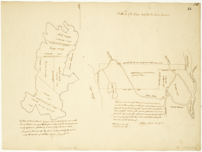
Description
Two maps:
"A plan of Moose Island lying in the mouth of Indian river in the Town of Addison, County of Washington, containing five hundred and ninety eight acres- plotted by a scale of forty rods to one inch. Surveyed in December 1819."
"This plan represents eight thousand acres of land, which was granted to Thomas Johnson & others, by order of the General Court passed the twenty fourth day of January One thousand eight hundred and fifteen, situated on the west side of Penobscot River, and is a part of Township number Four of the old Indian Purchase (so called) and was surveyed by Joseph Treat, Esq. in the month of October 1818 by the order and under the direction of Lothrop Lewis, Survey'r Gen'l. plotted by a scale of 200 rods to one inch."
Broad Creation Date
1818-1819
Language
English
Location
Washington County; Addison; Penobscot County; Old Town; Orono
Other Location
Moose Island; Pushaw Stream; Mud Pond; Stillwater River; Orson Island; Orono Island; Sunkhaze Stream
Keywords
Cartography; Maps; Maine Land Office; Planbooks; Surveys
Rights Statement
No Copyright - United States. URI: http://rightsstatements.org/vocab/NoC-US/1.0/
The organization that has made the Item available believes that the Item is in the Public Domain under the laws of the United States, but a determination was not made as to its copyright status under the copyright laws of other countries. The Item may not be in the Public Domain under the laws of other countries. Please refer to the organization that has made the Item available for more information.