


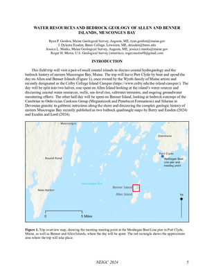
The Maine Geological Survey provides the people and businesses of Maine with essential geologic information about the land where we live and work.
Note: Many state documents are offered in PDF format. To view PDF documents, you will need the free Adobe Reader. If you need assistance, view our Maine government PDF Help page or contact the contributing Maine State agency via the link on the left sidebar under “Links”.
-

Glaciomarine deltas of Maine and their relation to late Pleistocene-Holocene crustal movements
Woodrow B. Thompson, Kristine J. Crossen, Harold W. Borns Jr, and Bjorn G. Andersen
in Anderson, Walter A., and Borns, Harold W., Jr. (editors), Neotectonics of Maine: studies in seismicity, crustal warping, and sea level change: Maine Geological Survey, Bulletin 40, p. 43-67.
-

Holocene sea-level change in coastal Maine
Daniel F. Belknap, R Craig Shipp, Robert Stuckenrath, Joseph T. Kelley, and Harold W. Borns Jr
in Anderson, Walter A., and Borns, Harold W., Jr. (editors), Neotectonics of Maine: studies in seismicity, crustal warping, and sea level change: Maine Geological Survey, Bulletin 40, p. 85-105.
-

Hurricane Mountain Formation melange; description and tectonic significance of a Penobscottian accretionary complex
Gary McG Boone, David T. Doty, and Matthew T. Heizler
in Tucker, Robert D., and Marvinney, Robert G. (editors), Studies in Maine geology: Volume 2 - Structure and stratigraphy: Maine Geological Survey, p. 33-83.
-

Hydrogeology and water quality of significant sand and gravel aquifers in parts of Aroostook County, Maine
Daniel B. Locke, Judy I. Steiger, Thomas K. Weddle, and Craig D. Neil
Maine Geological Survey, Open-File Report 89-1a. Accompanies 1:24000 Significant Aquifer Maps
-

Implications of the Rb-Sr and O istopic systematics and geochemistry of some two-mica granites in northern New England
Jennifer A. Hayward
in Tucker, Robert D., and Marvinney, Robert G. (editors), Studies in Maine Geology: Volume 3 - Igneous and metamorphic geology: Maine Geological Survey, p. 53-66.
-

Interpretation of the regional significance of the Chain Lakes massif, Maine, based upon preliminary isotopic studies
Michael M. Cheatham, William J. Olszewski, and Henri E. Gaudette
in Tucker, Robert D., and Marvinney, Robert G. (editors), Studies in Maine geology: Volume 4 - igneous and metamorphic geology: Maine Geological Survey, p. 125-137.
-

Late-glacial dunes, ventifacts, and wind direction in west-central Maine
John B. McKeon
in Tucker, Robert D., and Marvinney, Robert G. (editors), Studies in Maine geology: Volume 6 - Quaternary geology: Maine Geological Survey, p. 89-101.
-

Late Quaternary glacial history of Mt. Katahdin and the nunatak hypothesis
P Thompson Davis
in Tucker, Robert D., and Marvinney, Robert G. (editors), Studies in Maine geology: Volume 6 - Quaternary geology: Maine Geological Survey, p. 119-134.
-

Late Wisconsinan deglaciation of coastal Maine
Geoffrey W. Smith and Lewis E. Hunter
in Tucker, Robert D., and Marvinney, Robert G. (editors), Studies in Maine geology: Volume 6 - Quaternary geology: Maine Geological Survey, p. 13-32.
-

Late Wisconsinan glacial and glaciomarine sedimentary facies in the lower Androscoggin Valley, Topsham, Maine
Michael J. Retelle and Katherine M. Bither
in Tucker, Robert D., and Marvinney, Robert G. (editors), Studies in Maine geology: Volume 6 - Quaternary geology: Maine Geological Survey, p. 33-51.
-

Late Wisconsin glacial geology of the eastern portion of Mount Desert Island
Thomas V. Lowell
in Tucker, Robert D., and Marvinney, Robert G. (editors), Studies in Maine geology: Volume 6 - Quaternary geology: Maine Geological Survey, p. 103-118.
-

Major influences on lake water chemistry in Maine
Stephen A. Norton, David F. Brakke, Jeffrey S. Kahl, and Terry A. Haines
in Tucker, Robert D., and Marvinney, Robert G. (editors), Studies in Maine geology: Volume 5 - Quaternary geology: Maine Geological Survey, p. 109-124.
-

Mesozoic dikes of southern coastal Maine; an historical perspective and update on research, 1838-1988
Mark T. Swanson
in Tucker, Robert D., and Marvinney, Robert G. (editors), Studies in Maine geology: Volume 3 - igneous and metamorphic geology: Maine Geological Survey, p. 79-89.
-

Metamorphism in Maine: an overview
Charles V. Guidotti
in Tucker, Robert D., and Marvinney, Robert G. (editors), Studies in Maine geology: Volume 3 - igneous and metamorphic geology: Maine Geological Survey, p. 1-17. in Studies in Maine Geology: Volume 3
-

Morphodynamics of tidal inlet systems in Maine
Duncan M. FitzGerald, Jonathan M. Lincoln, L Kenneth Fink Jr, and Dabney W. Caldwell
in Tucker, Robert D., and Marvinney, Robert G. (editors), Studies in Maine geology: Volume 5 - Quaternary geology: Maine Geological Survey, p. 67-96.
-

Multiple folding in south-central Maine
Christopher Mulry
in Tucker, Robert D., and Marvinney, Robert G. (editors), Studies in Maine Geology: Volume 2 - structure and stratigraphy: Maine Geological Survey, p. 163-171.
-

Multiple thermal metamorphism of the Digdeguash Formation in the contact aureole of the Pocomoonshine gabbro-diorite, southeastern Maine
Allan Ludman, Sandra L. Bromble, and James M. DeMartinis
in Tucker, Robert D., and Marvinney, Robert G. (editors), Studies in Maine geology: Volume 4 - igneous and metamorphic geology: Maine Geological Survey, p. 163-175.
-

Neotectonic activity in coastal Maine
Walter A. Anderson, Harold W. Borns Jr, Joseph T. Kelley, and Woodrow B. Thompson
in Anderson, Walter A., and Borns, Harold W., Jr. (editors), Neotectonics of Maine: studies in seismicity, crustal warping, and sea level change: Maine Geological Survey, Bulletin 40, p. 1-10.
-

Neotectonics of Maine; studies in seismicity, crustal warping, and sea-level change
Walter A. Anderson and Harold W. Borns Jr
Maine Geological Survey, Bulletin 40. Includes technical papers on neotectonic activity in coastal Maine, geophysics of the Passamaquoddy Bay area, geology of southwestern coastal Maine, glaciomarine deltas related to crustal movements, inventory of salt marshes, Holocene sea-level change in coastal Maine, seismic reflection investigation of neotectonics of coastal Maine, archaeological evidence of coastal subsidence, postglacial bedrock faulting, geodetic evidence of crustal motion, geomechanical aspects of subsidence.
-

Origin and sedimentation of Maine lakes with emphasis on lake-outlet deltas
Dabney W. Caldwell, Duncan M. FitzGerald, and Michael S. Fenster
in Tucker, Robert D., and Marvinney, Robert G. (editors), Studies in Maine geology: Volume 5 - Quaternary geology: Maine Geological Survey, p. 97-108.
-

Peat and its occurrence as a resource in Maine
Cornelia C. Cameron
in Tucker, Robert D., and Marvinney, Robert G. (editors), Studies in Maine geology: Volume 5 - Quaternary geology: Maine Geological Survey, p. 125-146.
-

Petrographic and geochemical variations within the Songo pluton, western Maine
David Gibson and Daniel R. Lux
in Tucker, Robert D., and Marvinney, Robert G. (editors), Studies in Maine geology: Volume 4 - igneous and metamorphic geology: Maine Geological Survey, p. 87-100.
-

Polyphase deformation in the Penobscot Bay area, coastal Maine
John P. Kaszuba and Carol Simpson
in Tucker, Robert D., and Marvinney, Robert G. (editors), Studies in Maine Geology: Volume 2 - structure and stratigraphy: Maine Geological Survey, p. 145-161.
-

Postglacial bedrock faulting in Maine
Donaldson Koons
in Anderson, Walter A., and Borns, Harold W., Jr. (editors), Neotectonics of Maine: studies in seismicity, crustal warping, and sea level change: Maine Geological Survey, Bulletin 40, p. 149-155.
-

Postglacial evolution of drainage in the middle and upper St. John River basin, Maine and New Brunswick
J Steven Kite and Robert Stuckenrath
in Tucker, Robert D., and Marvinney, Robert G. (editors), Studies in Maine geology: Volume 6 - Quaternary geology: Maine Geological Survey, p. 135-142.
-

Prehistoric archaeology and evidence of coastal subsidence on the coast of Maine
David Sanger and Douglas C. Kellogg
in Anderson, Walter A., and Borns, Harold W., Jr. (editors), Neotectonics of Maine: studies in seismicity, crustal warping, and sea level change: Maine Geological Survey, Bulletin 40, p. 107-126.
-

Preliminary studies of five Mesozoic stocks in the Newfield 15' quadrangle, Maine
Richard A. Gilman
in Tucker, Robert D., and Marvinney, Robert G. (editors), Studies in Maine geology: Volume 4 - igneous and metamorphic geology: Maine Geological Survey, p. 79-86.
-

Radon, geology, and human health in Maine
Stephen A. Norton, Charles T. Hess, and Willem F. Brutsaert
in Tucker, Robert D., and Marvinney, Robert G. (editors), Studies in Maine geology: Volume 5 - Quaternary geology: Maine Geological Survey, p. 169-176.
-

Relative sea-level changes measured by historic records and structures in coastal Maine
David C. Smith, Harold W. Borns Jr, and R Scott Anderson
in Anderson, Walter A., and Borns, Harold W., Jr. (editors), Neotectonics of Maine: studies in seismicity, crustal warping, and sea level change: Maine Geological Survey, Bulletin 40, p. 127-137.
-

Sedimentary facies and tectonic interpretation of the Lower Devonian Carrabassett Formation, north-central Maine
Lindley S. Hanson and Dwight C. Bradley
in Tucker, Robert D., and Marvinney, Robert G. (editors), Studies in Maine Geology: Volume 2 - structure and stratigraphy: Maine Geological Survey, p. 101-125.
-

Silurian roundstone conglomerates of coastal Maine and adjacent New Brunswick
Olcott Gates
in Tucker, Robert D., and Marvinney, Robert G. (editors), Studies in Maine Geology: Volume 2 - structure and stratigraphy: Maine Geological Survey, p. 127-144.
-

Stratified, waterlain glacigenic sediments and the 'New Sharon Soil,' New Sharon, Maine
Thomas K. Weddle
in Tucker, Robert D., and Marvinney, Robert G. (editors), Studies in Maine geology: Volume 6 - Quaternary geology: Maine Geological Survey, p. 53-69.
-

Stream-sediment geochemistry of the Attean quartz monzonite and nearby rocks, Somerset and Franklin Counties, Maine
Gary A. Nowlan
in Tucker, Robert D., and Marvinney, Robert G. (editors), Studies in Maine geology: Volume 3 - igneous and metamorphic geology: Maine Geological Survey, p. 111-130.
-

Studies in Maine geology: Volume 2 - Structure and stratigraphy
Robert D. Tucker and Robert G. Marvinney
Maine Geological Survey. Includes technical papers on the stratigraphy of eastern Maine and western New Brunswick, description and tectonic significance of the Hurricane Mtn. mélange, the Depot Mtn. Formation in northwestern Maine, sedimentary facies and tectonic interpretation of the Carrabassett Formation, Silurian roundstone conglomerates of coastal Maine, polyphase deformation in the Penobscot Bay area, multiple folding in south-central Maine, thrust and strike-slip faults near Jackman, and geologic and geomechanical properties of the Mount Waldo granite.
-

Studies in Maine geology: Volume 3 - Igneous and metamorphic geology
Robert D. Tucker and Robert G. Marvinney
Maine Geological Survey. Includes technical papers on metamorphism in Maine, a thermal model for Carboniferous metamorphism near the Sebago batholith, Carboniferous Barrovian metamorphism in southern Maine, isotopic systematics and geochemistry of two-mica granites in northern New England, commingling of diverse magma types in the Flagstaff Lake Igneous Complex, Mesozoic dikes of southern coastal Maine, geochemical aspects of volcanic rocks in east Penobscot Bay, and stream sediment geochemistry of the Attean quartz monzonite.
-

Studies in Maine geology: Volume 4 - Igneous and metamorphic geology
Robert D. Tucker and Robert G. Marvinney
Maine Geological Survey. Includes technical papers on plutonism in the coastal Maine magmatic province, commingled gabbroic and granitic magmas in the northern Bays-of-Maine igneous complex, geochemistry of the granite-gabbro complex on Vinalhaven Island, geology and geochemistry of the Rattlesnake Mtn. igneous complex, Mesozoic stocks in the Newfield quadrangle, petrographic and geochemical variations within the Songo pluton, geochronology of the Songo pluton, isotopic dating of the Horserace quartz diorite, regional significance of the Chain Lakes massif, geochemistry of the Catheart Mtn. porphyry copper deposit, and multiple thermal metamorphism of the Digdeguash Formation in the contact aureole of the Pocomoonshine gabbro-diorite.
-

Studies in Maine geology: Volume 5 - Quaternary geology
Robert D. Tucker and Robert G. Marvinney
Maine Geological Survey. Includes technical papers on the timing and mechanisms for deposition of the glaciomarine mud in the Gulf of Maine, a submerged shoreline on the inner continental shelf of the western Gulf of Maine, depositional sequence modeling of Late Quaternary evolution for the west-central Maine coast, geomorphology and Late Quaternary evolution of the Saco Bay region, morphodynamics of tidal inlet systems in Maine, origin and sedimentation of Maine lakes emphasizing lake-outlet deltas, major influences on lake water chemistry, peat resources in Maine, lithologic and structural control on the geomorphology of mountainous areas in north-central Maine, and radon in Maine.
-

Studies in Maine geology: Volume 6 - Quaternary geology
Robert D. Tucker and Robert G. Marvinney
Maine Geological Survey. Includes technical papers on the history of Quaternary surficial geologic studies in Maine, Late Wisconsinan deglaciation of coastal Maine, Late Wisconsinan glacial and glaciomarine sedimentary facies in the lower Androscoggin Valley, stratified, waterlain glacigenic sediments and the "New Sharon Soil" deglaciation of the upper Androscoggin River valley and northeastern White Mtns., late-glacial dunes, ventifacts, and wind direction in west-central Maine, Late Wisconsin glacial geology of eastern Mount Desert Island, Late Quaternary glacial history of Mt. Katahdin, postglacial drainage evolution of the St. John River basin.
-

The commingling of diverse magma types in the Flagstaff Lake Igneous Complex
Roger L. Nielsen, Emily S. Landis, Vincent M. Ceci, and Cynthia Poston
in Tucker, Robert D., and Marvinney, Robert G. (editors), Studies in Maine Geology: Volume 3 - Igneous and metamorphic geology: Maine Geological Survey, p. 67-78.
-

The Depot Mountain Formation; transition from syn- to post-Taconian basin along the Baie Verte-Brompton line in northwestern Maine
David C. Roy
in Tucker, Robert D., and Marvinney, Robert G. (editors), Studies in Maine Geology: Volume 2 - structure and stratigraphy: Maine Geological Survey, p. 85-99.
-

The geology and geophysics of the Passamaquoddy Bay area, Maine and New Brunswick, and their bearing on local subsidence
Olcott Gates
in Anderson, Walter A., and Borns, Harold W., Jr. (editors), Neotectonics of Maine: studies in seismicity, crustal warping, and sea level change: Maine Geological Survey, Bulletin 40, p. 11-24.
-

The lithologic and structural controls on the geomorphology of the mountainous areas in north-central Maine
Lindley S. Hanson and Dabney W. Caldwell
in Tucker, Robert D., and Marvinney, Robert G. (editors), Studies in Maine geology: Volume 5 - Quaternary geology: Maine Geological Survey, p. 147-167.
-

The seismicity of Maine
John E. Ebel
in Anderson, Walter A., and Borns, Harold W., Jr. (editors), Neotectonics of Maine: studies in seismicity, crustal warping, and sea level change: Maine Geological Survey, Bulletin 40, p. 219-228.
-

Thrust and strike-slip faults near Jackman, Maine
Robert G. Marvinney
in Tucker, Robert D., and Marvinney, Robert G. (editors), Studies in Maine Geology: Volume 2 - structure and stratigraphy: Maine Geological Survey, p. 173-185.
-

Timing and mechanisms for the deposition of the glaciomarine mud in and around the Gulf of Maine; a discussion of alternative models
Robert N. Oldale
in Tucker, Robert D., and Marvinney, Robert G. (editors), Studies in Maine geology: Volume 5 - Quaternary geology: Maine Geological Survey, p. 1-10.
-
 unconformity at Flanders Bay, Maine by Richard A. Gilman and Gary G. Lash")
A Silurian(?) unconformity at Flanders Bay, Maine
Richard A. Gilman and Gary G. Lash
in Tucker, Robert D., and Marvinney, Robert G. (editors), Studies in Maine geology: Volume 1 - Structure and stratigraphy: Maine Geological Survey, p. 75-80.
-

Charles Thomas Jackson and the first geological survey of Maine, 1836-1838
Mark Hineline
in Tucker, Robert D., and Marvinney, Robert G. (editors), Studies in Maine geology: Volume 1 - Structure and stratigraphy: Maine Geological Survey, p. 1-16.
-

Contributions to the Quaternary geology of northern Maine and adjacent Canada
J Steven Kite, Thomas V. Lowell, and Woodrow B. Thompson
Maine Geological Survey, Bulletin 37. Bulletin to accompany the 49th annual meeting of the Friends of the Pleistocene, May 1986. Papers on reconstructing paleo ice sheets, till stratigraphy, glacial dispersal, glaciation and deglaciation of northwestern Maine, deglaciation in southeastern Quebec, ice movements in northwestern New Brunswick, and the archaeology of the Upper St. John River.
-

Definition, problems, and reinterpretation of early premetamorphic faults in western Maine and northeastern New Hampshire
Robert H. Moench and Kost A. Pankiwskyj
in Tucker, Robert D., and Marvinney, Robert G. (editors), Studies in Maine geology: Volume 1 - Structure and stratigraphy: Maine Geological Survey, p. 35-50.
-

Geologic relations within the shale-wacke sequence in south-central Maine
Philip H. Osberg
in Tucker, Robert D., and Marvinney, Robert G. (editors), Studies in Maine geology: Volume 1 - Structure and stratigraphy: Maine Geological Survey, p. 51-73.
-

Geomorphology and sedimentary framework of the inner continental shelf of central Maine
Joseph T. Kelley and Daniel F. Belknap
Maine Geological Survey, Open-File Report 88-6. Seismic reflection profiles, side-scan sonar images, bottom sediment composition and texture. Offshore coverage from Pemaquid Point to Port Clyde.
-

Hydrogeology and water quality of significant sand and gravel aquifers in parts of Hancock, Penobscot, and Washington Counties, Maine; significant sand and gravel aquifer maps 24, 25, 26, 27, 45
Thomas K. Weddle, Andrews L. Tolman, John S. Williams, James T. Adamik, Craig D. Neil, and Judy I. Steiger
Maine Geological Survey, Open-File Report 88-7a. Accompanies 1:24000 Significant Aquifer Maps
-

Lithotectonic stratigraphy, deformation, plutonism, and metamorphism, greater Casco Bay region, southwestern Maine
Arthur M. Hussey II
in Tucker, Robert D., and Marvinney, Robert G. (editors), Studies in Maine geology: Volume 1 - Structure and stratigraphy: Maine Geological Survey, p. 17-34.
-

Lower Devonian deltaic sedimentary environments and ecology: examples from the Matagamon Sandstone, northern Maine
Stephen G. Pollock, Arthur J. Boucot, and Bradford A. Hall
in Tucker, Robert D., and Marvinney, Robert G. (editors), Studies in Maine geology: Volume 1 - Structure and stratigraphy: Maine Geological Survey, p. 81-99.
-
 from the Lower Devonian Seboomook Formation in the Telos Lake area, north-central Maine by J Steven Kite and Thomas W. Kammer")
Occurrence of the crinoid Rhodocrinites nortoni (Goldring) from the Lower Devonian Seboomook Formation in the Telos Lake area, north-central Maine
J Steven Kite and Thomas W. Kammer
in Tucker, Robert D., and Marvinney, Robert G. (editors), Studies in Maine geology: Volume 1 - Structure and stratigraphy: Maine Geological Survey, p. 101-108.
-

Peat accumulation rates in selected Maine peat deposits
Kimmo Tolonen, Ronald B. Davis, and Lissa S. Widoff
Maine Geological Survey, Bulletin 33. Study of peat accumulation rates in 10 deposits. Includes comparative diagrams and tables of accumulation rates, pollen diagrams, moss increment and radio-carbon dates, and decomposition studies..
-

Plant paleontology in the State of Maine - a review
Andrew E. Kasper Jr, Patricia G. Gensel, William H. Forbes, and Henry N. Andrews Jr
in Tucker, Robert D., and Marvinney, Robert G. (editors), Studies in Maine geology: Volume 1 - Structure and stratigraphy: Maine Geological Survey, p. 109-128.
-

Pleistocene stratigraphy of the Augusta and Waldoboro areas, Maine
Woodrow B. Thompson and Geoffrey W. Smith
Maine Geological Survey, Bulletin 27. Guidebook for the 46th Annual Meeting of the Friends of the Pleistocene, May 1983. Field trip guide to glacial and glaciomarine deposits.
-

Seismic structure of the Earth's crust underlying the State of Maine
Alan L. Kafka and John E. Ebel
in Tucker, Robert D., and Marvinney, Robert G. (editors), Studies in Maine geology: Volume 1 - Structure and stratigraphy: Maine Geological Survey, p. 137-156.
-

Studies in Maine geology: Volume 1 - Structure and stratigraphy
Robert D. Tucker and Robert G. Marvinney
Maine Geological Survey. Includes technical papers on C.T. Jackson, the lithotectonic stratigraphy of the Casco Bay region, early premetamorphic faults in western Maine, the shale-wacke sequence in south-central Maine, a Silurian unconformity at Flanders Bay, Devonian deltaic sedimentary environments of the Matagamon Sandstone, the occurrence of the crinoid Rhodocrinites nortoni (Goldring) in north-central Maine, plant paleontology in Maine, the seismic structure of the earth's crust underlying Maine, and an electron microscope study of the Vassalboro Formation.
-

The geology of Mount Desert Island; a visitor's guide to the geology of Acadia National Park
Richard A. Gilman, Carleton A. Chapman, Thomas V. Lowell, and Harold W. Borns Jr
Maine Geological Survey, Bulletin 38. (Booklet out of print. Original maps superseded, available separately). Popular guide to park geology. Includes color surficial and bedrock geology maps of Mount Desert Island and black-and-white maps of Isle au Haut and Schoodic Point.
-

Transmission electron microscope study of bedding-cleavage relations in the Vassalboro Formation, east-central Maine
Beth Z. Lincoln
in Tucker, Robert D., and Marvinney, Robert G. (editors), Studies in Maine geology: Volume 1 - Structure and stratigraphy: Maine Geological Survey, p. 129-135.
-

Geomorphology and sedimentary framework of the inner continental shelf of south-central Maine
Joseph T. Kelley, Daniel F. Belknap, and R Craig Shipp
Maine Geological Survey, Open-File Report 87-19. Seismic reflection profiles, side-scan sonar images, bottom sediment composition and texture. Offshore coverage from Cape Elizabeth to Boothbay Harbor.
-

Geomorphology and sedimentary framework of the inner continental shelf of southwestern Maine
Joseph T. Kelley, RC Shipp, and Daniel F. Belknap
Maine Geological Survey, Open-File Report 87-5. Seismic reflection profiles, side-scan sonar images, bottom sediment composition and texture. Offshore coverage from Kittery to Cape Elizabeth.
-

Ground water handbook for the State of Maine
W Bradford Caswell
Maine Geological Survey, Bulletin 39. Discusses principles of ground water hydrology, Maine's water situation, available hydrogeologic data, and specific problems and case studies. Written in non-technical style.
-

Hydrogeology and water quality of significant sand and gravel aquifers in parts of Androscoggin, Cumberland, Oxford, and York Counties, Maine
John S. Williams, Dorothy H. Tepper, Andrews L. Tolman, and Woodrow B. Thompson
Maine Geological Survey, Open-File Report 87-1a. Accompanies 1:24000 Significant Aquifer Maps
-

Hydrogeology and water quality of significant sand and gravel aquifers in parts of Franklin, Kennebec, Knox, Lincoln, Penobscot, Somerset, and Waldo Counties, Maine; significant sand and gravel maps 18, 30, and 31
James T. Adamik, Andrews L. Tolman, John S. Williams, and Thomas K. Weddle
Maine Geological Survey, Open-File Report 87-24a. Accompanies 1:24000 Significant Aquifer Maps
-

Landslides in the Presumpscot Formation: An engineering study
Jeannine Amos and Thomas C. Sandford
Maine Geological Survey, Open-File Report 87-4. Discussion of Presumpscot Formation characteristics and analysis of Bunganuc and Gorham landslides.
-

Gravity and its geological interpretation: the Sebago pluton and vicinity, southwestern Maine
Consultant Consultant
Maine Geological Survey, Open-File Report 86-15. Available gravity data reprocessed to prepare Bouguer gravity maps for Sebago pluton.
-

Ice flow and deglaciation: Northwestern Maine
Thomas V. Lowell and J Steven Kite
Maine Geological Survey, Open-File Report 86-18. Guidebook for 49th Annual Friends of the Pleistocene field trip
-

Faulting in the Grand Falls area, Kellyland 15-minute quadrangle, eastern Maine
Allan Ludman
Maine Geological Survey, Open-File Report 85-72. Discussion of structural features at two localities in the Grand Falls area.
-

Hydrogeology and water quality of significant sand and gravel aquifers in parts of Androscoggin, Cumberland, Franklin, Kennebec, Lincoln, Oxford, Sagadahoc, and Somerset Counties, Maine; sand and gravel aquifer maps 10, 11, 16, 17, and 32
Dorothy H. Tepper, John S. Williams, Andrews L. Tolman, and Glenn C. Prescott Jr
Maine Geological Survey, Open-File Report 85-82a. Accompanies 1:24000 Significant Aquifer Maps
-

Radon in the domestic environment and its relationship to cancer: an epidemiological study
Melanie E. Lanctot
Maine Geological Survey, Open-File Report 85-88. M.S. thesis
-

Sea-level rise and archaeology in the Damariscotta River
David Sanger
Maine Geological Survey, Open-File Report 85-74. Progress report on field work.
-

Sea-level rise in Passamaquoddy Bay: archaeology and sediment cores
David Sanger
Maine Geological Survey, Open-File 85-73. Progress report on field work.
-

St. Croix region crustal strain study
David Tyler and Alfred Leick
Maine Geological Survey Open-File 85-76. Resurvey of triangulation stations in St. Croix area.
-
![Surficial geology of the Fish River Lake [15-minute] quadrangle, Maine by Eric F. Halter](https://digitalmaine.com/mgs_publications/1042/thumbnail.jpg "Surficial geology of the Fish River Lake [15-minute] quadrangle, Maine by Eric F. Halter")
Surficial geology of the Fish River Lake [15-minute] quadrangle, Maine
Eric F. Halter
Maine Geological Survey, Open-File Report 85-83. Brief description of surficial deposits; accompanies Open-File Map 86-48.
-

Hydrologic data for the Great and Denbow Heaths in eastern Maine, October 1980 through September 1981
William J. Nichols Jr, Joseph A. Smath, and James T. Adamik
Maine Geological Survey, Open-File Report 84-5. Data for surface water flow and ground water levels. Also published as USGS Open-File Report 83-866
-

Hydrologic data for the Great and Denbow Heaths in eastern Maine, October 1981 through October 1982
William J. Nichols Jr
Maine Geological Survey, Open-File Report 84-6. Data for surface-water flow and ground-water levels. Also published as USGS Open-File Report 83-865
-

Peat resources of Maine; Volume 1, Aroostook County
Cornelia C. Cameron, Michael K. Mullen, Carolyn A. Lepage, and Walter A. Anderson
Maine Geological Survey, Bulletin 28. Contains sketch maps of 42 peat deposits, core logs, proximate and ultimate analyses of samples.
-

Peat resources of Maine; Volume 2, Penobscot County
Cornelia C. Cameron, Michael K. Mullen, Carolyn A. Lepage, and Walter A. Anderson
Maine Geological Survey, Bulletin 29. Contains sketch maps of 47 peat deposits, core logs, proximate and ultimate analyses of samples.
-

Peat resources of Maine; Volume 3, Piscataquis and Somerset Counties
Cornelia C. Cameron, Michael K. Mullen, Carolyn A. Lepage, and Walter A. Anderson
Maine Geological Survey, Bulletin 30. Contains sketch maps of 49 peat deposits, core logs, proximate and ultimate analyses of samples.
-

Peat resources of Maine; Volume 4, Southern and western Maine
Cornelia C. Cameron, Michael K. Mullen, Carolyn A. Lepage, and Walter A. Anderson
Maine Geological Survey, Bulletin 31. Contains sketch maps of 46 peat deposits, core logs, proximate and ultimate analyses of samples.
-

Peat resources of Maine; Volume 5, Washington County
Cornelia C. Cameron, Michael K. Mullen, Carolyn A. Lepage, and Walter A. Anderson
Maine Geological Survey, Bulletin 32. Sketch maps of 48 peat deposits, core logs, proximate and ultimate analyses of samples.
-

Sources of water-use information in Maine
Dorothy H. Tepper and E Melanie Lanctot
Maine Geological Survey, Open-File Report 84-4. Description of National Water Use Data system and Maine Water Use Data system.
-

Analysis of structural features in southern Piscataquis County, Maine
Donald W. Newberg
Maine Geological Survey, Open-File 83-6. Analysis of structural features, kink band folding, and joints.
-

Evidence for late Holocene sea-level rise in New England; a summary of available data derived from salt marshes and other organic materials
R Scott Anderson and Harold W. Borns Jr
Maine Geological Survey, Open-File Report 83-8. Analysis of salt marsh data using core studies, sea-level curves, and radiometric dating.
-

Preliminary report on sea-level rise in the Damariscotta estuary, central Maine coast
David Sanger and Davida E. Kellogg
Maine Geological Survey, Open-File 83-9. Progress report on archaeological studies.
-

Structural analysis of the Guilford, Dover-Foxcroft, and Boyd Lake 15-minute quadrangles, south-central Maine
David S. Westerman
Maine Geological Survey, Open-File 83-7. Analysis of structural features
-

Maine peat resource evaluation program; 1980 field season
Cornelia C. Cameron, Carolyn A. Lepage, Walter A. Anderson, and J Davis
Maine Geological Survey, Open-File Report 82-8, 167 p. (superseded by Cameron, 1984, Maine Geological Survey, Bulletins 28-32)
-

The geology of the Two Lights and Crescent Beach State Parks area, Cape Elizabeth, Maine
Arthur M. Hussey II
Maine Geological Survey, Bulletin 26. Popular guide to park geology, geologic history, features of geologic interest
-

Evidence for late Holocene and recent sea level rise along coastal Maine utilizing salt marsh data
R Scott Anderson and Charles D. Race
Maine Geological Survey, Open-File Report 81-1. Progress report on sea level rise study.
-

Postglacial faulting in the vicinity of the Norumbega fault zone, eastern Maine
Woodrow B. Thompson
Maine Geological Survey, Open-File Report 81-48. Discussion of evidence for postglacial faulting. Also published as USGS Open-File Report 81-1039
-
![Reconnaissance surficial geology of the Bridgewater, Houlton, Howe Brook, and Smyrna Mills [15-minute] quadrangles, Maine by Thomas Brewer](https://digitalmaine.com/mgs_publications/1160/thumbnail.jpg "Reconnaissance surficial geology of the Bridgewater, Houlton, Howe Brook, and Smyrna Mills [15-minute] quadrangles, Maine by Thomas Brewer")
Reconnaissance surficial geology of the Bridgewater, Houlton, Howe Brook, and Smyrna Mills [15-minute] quadrangles, Maine
Thomas Brewer
Maine Geological Survey, Open-File Report 81-7. Brief description of surficial deposits; accompanies Open-File Maps 81-8, 81-9, 86-53, and 86-57.
-

Report on brittle fracture and bedrock mapping in the Bangor-Brooks-Stetson area of the Bangor 2-degree quadrangle, Maine
David S. Westerman
Maine Geological Survey, Open-file 81-89. Lineament and small-scale brittle fracture analysis.
-

Structural characteristics of the Northwestern Boundary fault in northern Franklin and Somerset Counties, Maine
Gary M. Boone
Maine Geological Survey, Open-File 81-3. Description of structural features in 6 localities.
-

Evaluation of the mineral potential, upper St. John River valley, Aroostook County, Maine: Appendix B: Geochemistry
Consultant Consultant
Maine Geological Survey, Open-File Report 80-14c. Analysis of 1100 samples for cold-extractable heavy metals and copper. Maps show locations of sample sites and concentrations of metals.
-

Evaluation of the mineral potential, upper St. John River valley, Aroostook County, Maine: Appendix D: Geophysics
Consultant Consultant
Maine Geological Survey, Open-File Report 80-14d. Magnetometer traverses of study area.
-

Investigation of salt marsh stratigraphy as an indicator of sea level rise in coastal Maine
R Scott Anderson and Charles D. Race
Maine Geological, Survey Open-File 80-1. Progress report on studies of salt marshes as evidence of crustal warping.
-

Maine Peat Resource Evaluation Program; 1979 field season
Joel Davis and Walter A. Anderson
Maine Geological Survey, Open-File Report 80-5, 94 p. (superseded by Cameron and others, 1984, Maine Geological Survey Bulletins 28-32)
-
![Preliminary report on the surficial geology of the Stacyville [15-minute] quadrangle, northern half of the Millinocket [15-minute] quadrangle, eastern half of the Katahdin [15-minute] quadrangle, and the northeastern quarter of the Norcross [15-minute] quadrangle, Maine by William A. Newman](https://digitalmaine.com/mgs_publications/1154/thumbnail.jpg "Preliminary report on the surficial geology of the Stacyville [15-minute] quadrangle, northern half of the Millinocket [15-minute] quadrangle, eastern half of the Katahdin [15-minute] quadrangle, and the northeastern quarter of the Norcross [15-minute] quadrangle, Maine by William A. Newman")
Preliminary report on the surficial geology of the Stacyville [15-minute] quadrangle, northern half of the Millinocket [15-minute] quadrangle, eastern half of the Katahdin [15-minute] quadrangle, and the northeastern quarter of the Norcross [15-minute] quadrangle, Maine
William A. Newman
Maine Geological Survey, Open-File Report 80-15. Brief description of surficial deposits; accompanies Open-File Maps 86-49, 86-60, 81-39, and 86-50
-

Tourmaline; a prospecting guide for massive base-metal sulfide deposits in the Penobscot Bay area, Maine
John F. Slack
Maine Geological Survey, Special Economic Studies Series 8
-

Vertical crustal movement in Maine
David A. Tyler and Jon W. Ladd
Maine Geological Survey, Open-File Report 80-34. Describes vertical crustal motion in Maine through analysis of repeated first order level data.
-

Crustal subsidence in eastern Maine
David A. Tyler, Jon Ladd, and Harold W. Borns Jr
Maine Geological Survey, Open-File Report 79-24. Comparison of vertical leveling data from 1942 and 1966 surveys. Plate shows crustal movement on a line from Bangor to Calais.
-

Historical evidence of sea-level change along the Maine coast
David C. Smith
Maine Geological Survey, Open-File 79-23. Discusses evidence of sea-level rise shown by salt marsh dikes, wharves, mill sites, etc.
-
![Preliminary report on the surficial geology of the Sherman, Mattawamkeag Lake, and the northern half of the Mattawamkeag and Wytopitlock [15-minute] quadrangles, Maine by William A. Newman](https://digitalmaine.com/mgs_publications/1149/thumbnail.jpg "Preliminary report on the surficial geology of the Sherman, Mattawamkeag Lake, and the northern half of the Mattawamkeag and Wytopitlock [15-minute] quadrangles, Maine by William A. Newman")
Preliminary report on the surficial geology of the Sherman, Mattawamkeag Lake, and the northern half of the Mattawamkeag and Wytopitlock [15-minute] quadrangles, Maine
William A. Newman
Maine Geological Survey, Open-File Report 79-21. Brief description of glacial stratigraphy; accompanies Open-File Maps 80-17, 80-16, 81-43 and 86-27
-
![Reconnaissance surficial geology of the Sebec, Schoodic, Lincoln, and the southern portions of the Jo-Mary Mtn., Norcross, and Millinocket [15-minute] quadrangles, Maine by Galen Kenoyer](https://digitalmaine.com/mgs_publications/1148/thumbnail.jpg "Reconnaissance surficial geology of the Sebec, Schoodic, Lincoln, and the southern portions of the Jo-Mary Mtn., Norcross, and Millinocket [15-minute] quadrangles, Maine by Galen Kenoyer")
Reconnaissance surficial geology of the Sebec, Schoodic, Lincoln, and the southern portions of the Jo-Mary Mtn., Norcross, and Millinocket [15-minute] quadrangles, Maine
Galen Kenoyer
Maine Geological Survey, Open-File Report 79-17. Discusses glacial stratigraphy of the area; accompanies Open-File Maps 80-10, 82-6, 80-12, 86-32, 86-50, 86-60
-

Report on field mapping in the Sherbrooke 2 degree quadrangle, northwestern Maine
David S. Westerman
Maine Geological Survey, Open-File Report 79-25. Describes lithology and structure in the Northwest Boundary fault zone. Map shows cleavage and fracture foliation and joints.
-

Preliminary geologic survey of potential underground oil storage sites in Maine
Charles V. Guidotti and Robert G. Gerber
Maine Geological Survey, Open-File Report 77-3. Brief description of twelve coastal plutons.
-

Hydrogeology of Maine lakes
W Bradford Caswell
Maine Geological Survey, Open-File Report 75-18. General description of hydrology of lakes.
-

Surficial geology of the wildlands of the Greenville-Jackman areas, Maine
Dabney W. Caldwell
Maine Geological Survey, Open-File Report 75-6. Includes description of geology and unusual features in sixteen 15-minute quadrangles in the Greenville-Jackman area.
-

Surficial materials of the wildlands of northwestern Maine
Dabney W. Caldwell
Maine Geological Survey, Open-File Report 74-13. Includes description of geology and unique or critical features in eleven 15-minute quadrangles in northwestern Maine
-

Metamorphic stratigraphy, petrology, and structural geology of the Little Bigelow Mountain map area, western Maine
Gary McG Boone
Maine Geological Survey, Bulletin 24. Includes part of the Bingham 15' quadrangle.
-

History of sedimentation in Montsweag Bay
Detmar Schnitker
Maine Geological Survey, Bulletin 25. Discussion of sedimentation, seismic profiles.
-

Mesozoic plutonic-volcanic rocks of the Newfield quadrangle, Maine
Richard A. Gilman
Maine Geological Survey, Open-File Report 72-1. Description of five small discordant plutons
-

The geology of Baxter State Park and Mt. Katahdin
Dabney W. Caldwell
Maine Geological Survey, Bulletin 12, 57 p., illustrations (includes colored geologic maps 1:133,056) (superseded by Rankin and Caldwell, 2010, Maine Geological Survey Report B-43). Popular guide to park geology, geologic history, features of geologic interest.
-

A new Silurian fossil locality on Lawler Ridge, Sherman quadrangle, Maine
David C. Roy and William H. Forbes
in Shorter Contributions to Maine Geology: Maine Geological Survey (Department of Economic Development), Bulletin 23, p. 17-18.
-

Devonian slate problems in the northern Appalachians
Arthur J. Boucot
in Shorter Contributions to Maine Geology: Maine Geological Survey (Department of Economic Development), Bulletin 23, p. 42-48.
-

Geology of Limestone Hill, Stratton quadrangle, Somerset County, Maine
Kost A. Pankiwskyj
in Shorter Contributions to Maine Geology: Maine Geological Survey (Department of Economic Development), Bulletin 23, p. 19-26.
-

Observations on the origin and development of the Wells Beach area, Maine
Arthur M. Hussey II
in Shorter Contributions to Maine Geology: Maine Geological Survey (Department of Economic Development), Bulletin 23, p. 58-68.
-

Plant fossils of the Trout Valley Formation
Henry N. Andrews and Andrew E. Kasper
in Shorter Contributions to Maine Geology: Maine Geological Survey (Department of Economic Development), Bulletin No. 23, p. 3-16, illustrations (includes sketch map).
-

Rb-Sr whole rock ages of Silurian-Devonian volcanics from eastern Maine
Paul D. Fullagar and Michael L. Bottino
in Shorter Contributions to Maine Geology: Maine Geological Survey (Department of Economic Development), Bulletin 23, p. 49-52.
-

Shorter contributions to Maine geology
Henry N. Andrews, Andrew E. Kasper, David C. Roy, William H. Forbes, Kost A. Pankiwskyj, Gary M. Boone, Arthur J. Boucot, Paul D. Fullagar, Michael L. Bottino, Richard A. Gilman, and Arthur M. Hussey II
Maine Geological Survey (Department of Economic Development), Bulletin 23. Papers on plant fossils of the Trout Valley Formation, Silurian fossils on Lawler Ridge, Limestone Hill in Somerset county, Fish River Lake Formation, Devonian slates in the northern Appalachians, Rb-Sr ages of Silurian-Devonian volcanics in eastern Maine, structure of Sawyer Mountain area, origin and development of the Wells Beach area
-

Structural and stratigraphic studies in the Sawyer Mountain area, York County, Maine
Richard A. Gilman
in Shorter Contributions to Maine Geology: Maine Geological Survey (Department of Economic Development), Bulletin 23, p. 53-57.
-

The Fish River Lake Formation and its environments of deposition
Gary M. Boone
in Shorter Contributions to Maine Geology: Maine Geological Survey (Department of Economic Development), Bulletin 23, p. 27-41.
-

Geochemical stream sediment sampling survey, Rangeley, Maine, area
Walter A. Anderson
Maine Geological Survey (Department of Economic Development), Special Economic Studies Series 5
-

Geology of the Blue Hill - Castine mining district, southwestern Hancock county, Maine
Eric S. Cheney
Maine Geological Survey (Department of Economic Development), Open-File Report (Special Economic Studies Series 6)
-

Reconnaissance and economic geology of the northwestern Knox County marble belt
Eric S. Cheney
Maine Geological Survey (Department of Economic Development), Bulletin 19 (Special Economic Studies Series 7). Describes regional geology, correlation, and structure. Includes a short section on the economic value of marble belts and ores in NW Knox County. Plates include a reconnaissance geologic map and a map of the Union marble belt. Covers parts of Liberty, Belfast, Waldoboro, and Rockland 15' quadrangles.
-

Contributions to the geology of Maine
Maine Geological Survey
Maine Geological Survey (Department of Economic Development), Bulletin 18. Includes papers on mineralization of the south end of the Munsungun anticlinorium, Maine diatomite occurrences, the Owen Brook limestone prospect in Penobscot County, New Scotland depositional history of Beck Pond region, Silurian slide conglomerate in Addison
-

Diatomite in Maine
Frederick M. Beck
in Contributions to the Geology of Maine: Maine Geological Survey (Department of Economic Development), Bulletin 18, p. 10-17.
-

New Scotland depositional history of the Beck Pond region, Somerset County, Maine
A.J. Boucot, Charles Harper, and Keith Rhea
in Contributions to the Geology of Maine: Maine Geological Survey (Department of Economic Development), Bulletin 18, p. 23-61, illus., tables.
-

Outline of the geology and mineralization of the south end of the Munsungun anticlinorium, Piscataquis County, Maine
Bradford A. Hall
in Contributions to the Geology of Maine: Maine Geological Survey (Department of Economic Development), Bulletin 18, p. 5-9, illus., table.
-

Silurian subaqueous slide conglomerate, Addison, Maine
Richard A. Gilman
in Contributions to the Geology of Maine: Maine Geological Survey (Department of Economic Development), Bulletin 18, p. 64-77.
-

The Owen Brook limestone prospect, Penobscot County, Maine
Robert G. Doyler
in Contributions to the Geology of Maine: Maine Geological Survey (Department of Economic Development), Bulletin 18, p. 18-22, illus., table.
-

A detailed economic investigation of geochemical and aeromagnetic anomalies, north central Maine
Webster F. Stickney, Lawrence A. Wing, and Robert S. Young
Maine Geological Survey (Department of Economic Development), Special Economic Studies Series 4, 81 p., i-iii, illustrations, tables
-

The geology of Mount Blue State Park
Kost A. Pankiwskyj
Maine Geological Survey (Department of Economic Development), Bulletin 17 (State Park Geologic Series 3). Popular guide to park geology, geologic history, objects of geologic interest.
-

Prospect evaluations, Washington County, Maine
Robert S. Young
Maine Geological Survey (Department of Economic Development), Special Economic Studies Series 3
-

Prospect evaluations, Hancock County, Maine
Robert S. Young
Maine Geological Survey (Department of Economic Development), Special Economic Studies Series 2
-

A detailed economic investigation of aeromagnetic anomalies in eastern Penobscot County, Maine
Robert G. Doyle, Robert S. Young, and Lawrence A. Wing
Maine Geological Survey (Department of Economic Development), Special Economic Studies Series 1
-

Late Pleistocene changes of sea level in southwestern Maine
Arthur L. Bloom
Maine Geological Survey (Department of Economic Development), 143 p., maps (Originally presented in limited edition by the Office of Naval Research, Project No. NR 388-040, May 1959.)
-

Geology of the Beck Pond area, Township 3, Range 5, Somerset County, Maine
Arthur James Boucot, Charles Harper, and Keith Rhea
Maine Geological Survey (Department of Development of Industry and Commerce), Bulletin 8 (Special Geologic Studies Series 1), 33 p., illus. incl. geol. sketch maps
-

Glacial lake and glacial marine clays of the Farmington area, Maine - Origin and possible use as lightweight aggregate
Dabney W. Caldwell
Maine Geological Survey (Department of Economic Development), Bulletin 10 (Special Geologic Studies Series 3). Describes stratigraphy and origin of clay deposits and discusses physical, chemical, and thermal expansion properties of clay. Plates include clay distribution map of Sandy River area.
-

The geology of a six-mile section along Spencer Stream, Somerset County, Maine
Arthur James Boucot, John Roy Griffin, and Philip S. Perry
Maine Geological Survey (Department of Economic Development), Bulletin 9 (Special Geologic Studies Series 2), 28 p., illus. incl. geologic map
-

The geology of Sebago Lake State Park
Arthur Leroy Bloom
Maine Geological Survey (Department of Economic Development), Bulletin 11 (State Park Geologic Series 1). Popular guide to park geology, geologic history, features of geologic interest.
-

Maine granite quarries and prospects
Muriel B. Austin and Arthur M. Hussey II
Maine Geological Survey (Department of Economic Development), Minerals Resources Index 2, 50 p., illustrations
-

Maine metal mines and prospects
Arthur M. Hussey II, John R. Rand, and Muriel B. Austin
Maine Geological Survey (Department of Economic Development) Minerals Resources Index 3, 53 p., illustrations including geologic sketch maps
-

Maine pegmatite mines and prospects and associated minerals
John R. Rand, Dabney W. Caldwell, and Muriel B. Austin
Maine Geological Survey (Department of Development of Industry and Commerce), Minerals Resources Index 1, 43 p., illus., Mar. 1, 1957
-

Genetic study of some pyrrhotite deposits of Maine and New Brunswick
Robert S. Houston
Maine Geological Survey (Department of Development of Industry and Commerce), Bulletin 7, 117 p., illus. incl. geol. sketch maps
-

Pegmatites and associated rocks in the Newry Hill area, Oxford County, Maine
Vincent Everett Shainin and Louis Field Dellwig
Maine Geological Survey (Maine Development Commission), Bulletin 6, 58 p., illus. incl. geologic maps
-

Report of the State Geologist, 1953-1954
Joseph M. Trefethen
(Maine Geological Survey), Maine Development Commission
-

Report of the State Geologist, 1951-1952
Joseph M. Trefethen
(Maine Geological Survey), Maine Development Commission, 115 p.
-

Report of the State Geologist, 1949-1950
Joseph M. Trefethen
(Maine Geological Survey), Maine Development Commission, 160 p.
-

Report of the State Geologist, 1947-1948
Joseph M. Trefethen
(Maine Geological Survey), Maine Development Commission, 109 p.
-

Economic geology of some pegmatites in Topsham, Maine
Vincent Everett Shainin
Maine Geological Survey (Maine Development Commission), Bulletin 5, 32 p., illustrations, includes index, geologic map
-

Manganese deposits of Aroostook County, Maine
Ralph LeRoy Miller
Maine Geological Survey (Maine Development Commission), Bulletin 4, 77 p., illus. incl. index, geologic maps
-

Report of the State Geologist, 1945-1946
Joseph M. Trefethen
(Maine Geological Survey), Maine Development Commission, Augusta, Maine, 97 p.
-

Geology of the Katahdin pyrrhotite deposit and vicinity, Piscataquis County, Maine
Ralph LeRoy Miller
Maine Geological Survey (Maine Development Commission), Bulletin 2, 21 p., illus. incl. index, geologic maps
-

Report of the State Geologist, 1943-1944
Joseph M. Trefethen
(Maine Geological Survey), Maine Development Commission, 64 p.
-

Domestic fuel possibilities of Maine peat
Joseph M. Trefethen and Robert B. Bradford
Maine Geological Survey (Maine Development Commission), Bulletin 1, 47 p., illus. incl. index map
-

Report of the State Geologist, 1942-1943
Joseph M. Trefethen
(Maine Geological Survey), Orono, Maine, 36 p.
-

State Geologist's report on the geology of Maine, 1930-1932
Joseph C. Twinem and Edward H. Perkins
(Maine Geological Survey), Augusta, Maine, 152 p.
-

First annual report on the geology of the State of Maine
Lucius H. Merrill and Edward H. Perkins
(Maine Geological Survey), Augusta, Maine, 90 p.