


Preview
Contributing Institution
Maine Geological Survey
Document Type
Image
Identifier
9715
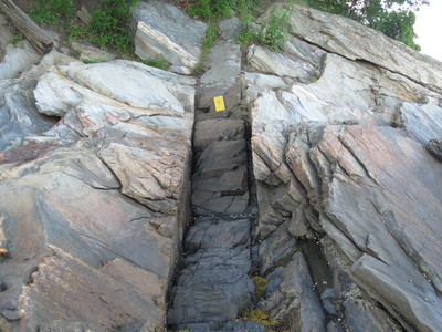
Description
Photo 10: View towards the northeast of a near-vertical dike of dark gray diabase cutting east-dipping gneisses of the Nehumkeag Pond Formation (Onp). Diabase is the youngest rock type in the Freeport quadrangle (about 200 million years old) and formed when fluid magma flowed rapidly up through cracks in the surrounding older rocks and then solidified. The locations of these dikes are shown on the map with red symbols. Shoreline exposure at Wolfe’s Neck Woods State Park approximately 1500 feet southwest of Googins Island, Freeport.
Project Name: Bedrock Geology 24k Freeport
Exact Creation Date
6-28-2017
Location
Freeport
Supplemental Rights
Credit must be given to the photographer and the Maine Geological Survey when this photo is displayed, reproduced, distributed and/or used in derivative works.
Keywords
bedrock mapping; outcrop; STATEMAP; Freeport