


Preview
Contributing Institution
Maine Geological Survey
Document Type
Image
Identifier
72157
Description
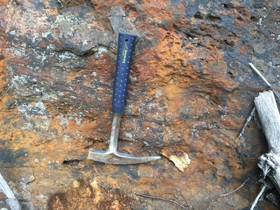
Photo 6: Very rusty weathering schist of the Sangerville Formation (Ssr). The rusty weathering is due to the oxidation of fine-grained iron sulfide minerals in the rock. Although not visible in this photo, the schist is silvery colored on freshly broken surfaces. 0.7 miles south of Sullivan Road, Greene.
Project Name: STATEMAP Lake Auburn East Bedrock24k
Exact Creation Date
8-11-2022
Location
Greene
Supplemental Rights
Credit must be given to the photographer and the Maine Geological Survey when this photo is displayed, reproduced, distributed and/or used in derivative works.
Keywords
bedrock mapping; outcrop; STATEMAP; Lake Auburn East