


Preview
Contributing Institution
Maine Geological Survey
Document Type
Image
Identifier
72149
Description
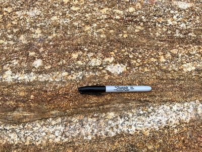
Photo 13: Outcrop surface of Cross River Formation (O0cr) with the upper part of the photo illustrating some of the distinguishing characteristics of the unit. The majority of the rock is a rusty-weathering, coarse-grained, migmatitic gneiss containing large cream-colored feldspars suspended in a finer grained foliated matrix rich in biotite and sillimanite (a.k.a. “popcorn texture”). A thin layer rich in sillimanite, a mineral exhibiting a needle-like habit, can be seen between the pen and the light-colored granitic layer. West of Hastings Pond, Bristol.
Project Name: STATEMAP Louds Island Bedrock24k
Exact Creation Date
5-26-2022
Location
Bristol
Supplemental Rights
Credit must be given to the photographer and the Maine Geological Survey when this photo is displayed, reproduced, distributed and/or used in derivative works.
Keywords
bedrock mapping; outcrop; STATEMAP; Louds Island