


Preview
Contributing Institution
Maine Geological Survey
Document Type
Image
Identifier
72139
Description
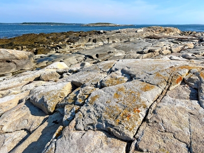
Photo 4: Exposures of biotite granite (Dbg) on the northern end of Haddock Island with Ross Island, similarly underlain by biotite granite, visible in the background. Granite outcrops in the quadrangle have flat to rounded profiles and are characteristically unlayered. These rocks, crystallized from silica-rich magma deep beneath Earth’s surface, are composed primarily of light-colored quartz and feldspar, and lesser amounts of dark-colored (biotite) and/or light-colored (muscovite) mica. Haddock Island, Muscongus Bay, Bristol.
Project Name: STATEMAP Louds Island Bedrock24k
Exact Creation Date
8-29-2022
Location
Bremen
Supplemental Rights
Credit must be given to the photographer and the Maine Geological Survey when this photo is displayed, reproduced, distributed and/or used in derivative works.
Keywords
bedrock mapping; outcrop; STATEMAP; Louds Island