


Preview
Contributing Institution
Maine Geological Survey
Document Type
Image
Identifier
72141
Description
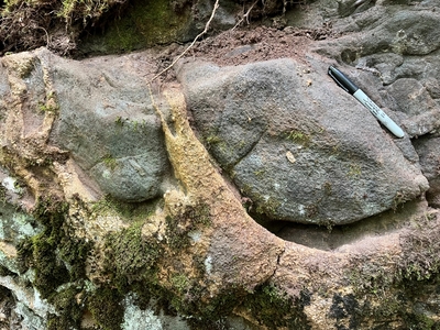
Photo 5: Crystallized commingled magmas in a dike (DScm). Weathering has enhanced the differences between the rock types. The rocks represent a solidified example of darker mafic (gabbro) and lighter felsic (granite) magma that commingled deep underground while still molten. Because of the contrasting viscosity of the two magmas, they behaved as immiscible liquids and did not mix. Although there are numerous Late Silurian examples of these rocks farther down the coast in Maine at St. George, Vinalhaven, and elsewhere, they are rare in the Louds Island quadrangle. West edge of quadrangle, south of Boyd Pond, Bristol.
Project Name: STATEMAP Louds Island Bedrock24k
Exact Creation Date
7-18-2022
Location
Bristol
Supplemental Rights
Credit must be given to the photographer and the Maine Geological Survey when this photo is displayed, reproduced, distributed and/or used in derivative works.
Keywords
bedrock mapping; outcrop; STATEMAP; Louds Island