


Preview
Contributing Institution
Maine Geological Survey
Document Type
Image
Identifier
72137
Description
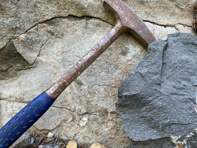
Photo 1: Both weathered (left) and freshly broken (right) surfaces of fine-grained diabase. Diabase represents the youngest rock type in the quadrangle and formed when hot silica-poor magma flowed rapidly through cracks in the surrounding older rocks and then solidified quickly into narrow dikes and sills. The rocks in this photo are from the Moxie Cove diabase dike (J2mc) – the only diabase body large enough to be shown at the scale of this map. The locations of additional smaller dikes are shown on the map with red symbols. Moxie Cove, Bristol.
Project Name: STATEMAP Louds Island Bedrock24k
Exact Creation Date
5-26-2022
Location
Bristol
Supplemental Rights
Credit must be given to the photographer and the Maine Geological Survey when this photo is displayed, reproduced, distributed and/or used in derivative works.
Keywords
bedrock mapping; outcrop; STATEMAP; Louds Island