


Preview
Contributing Institution
Maine Geological Survey
Document Type
Image
Identifier
72136
Description
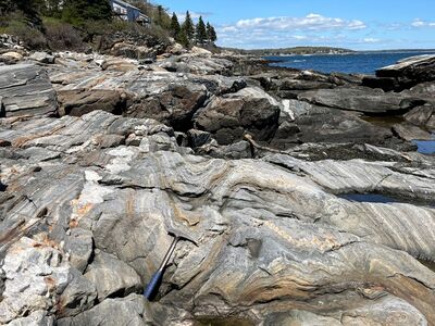
Photo 10: View towards the north-northeast of shallow-plunging, upright folds (f2) in layered granofels of the Bucksport Formation (Sb). These folds are more common than the earlier recumbent folds (f1) illustrated in Photo 9 and formed during roughly east-west directed crustal shortening associated with the Devonian Acadian orogeny. Note also the boudinaged light-colored granite dike on the left side of the photo. South of New Harbor, Bristol.
Project Name: STATEMAP New Harbor Bedrock24k
Exact Creation Date
5-24-2022
Location
Bristol
Supplemental Rights
Credit must be given to the photographer and the Maine Geological Survey when this photo is displayed, reproduced, distributed and/or used in derivative works.
Keywords
bedrock mapping; outcrop; STATEMAP; New Harbor