


Preview
Contributing Institution
Maine Geological Survey
Document Type
Image
Identifier
72128
Description
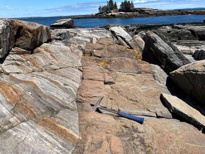
Photo 2: View toward the northeast of an approximately 1.5 meter wide, vertically dipping, porphyritic diabase dike cross-cutting layered metamorphic rocks of the Bucksport Formation (Sb). Diabase such as this represents the youngest rock type in the quadrangle (~200 million years old) and formed when hot silica-poor magma flowed rapidly through cracks in the surrounding older rocks and then solidified quickly. The locations of additional smaller dikes are shown on the map with red symbols. South of New Harbor, Bristol.
Project Name: STATEMAP New Harbor Bedrock24k
Exact Creation Date
5-24-2022
Location
Bristol
Supplemental Rights
Credit must be given to the photographer and the Maine Geological Survey when this photo is displayed, reproduced, distributed and/or used in derivative works.
Keywords
bedrock mapping; outcrop; STATEMAP; New Harbor