


Preview
Contributing Institution
Maine Geological Survey
Document Type
Image
Identifier
72129
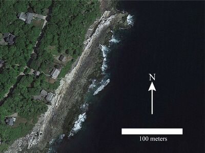
Description
Photo 3: Google Earth view of a portion of the shoreline south of New Harbor showing the relationship between pegmatite-dominated granitic intrusive igneous rocks (CDp) and stratified metamorphic rocks of the Bucksport Formation (Sb). The shoreline is oriented roughly parallel to the strike of layering (~025°) in the darker colored stratified metamorphic rocks that underlie the lower areas next to the water. Upper portions of the shoreline near the trees are underlain by lighter colored intrusive igneous rocks (pegmatitic granite). South of New Harbor, Bristol.
Project Name: STATEMAP New Harbor Bedrock24k
Exact Creation Date
12-28-2022
Location
Bristol
Supplemental Rights
Credit must be given to the photographer and the Maine Geological Survey when this photo is displayed, reproduced, distributed and/or used in derivative works.
Keywords
bedrock mapping; outcrop; STATEMAP; New Harbor