


Preview
Contributing Institution
Maine Geological Survey
Document Type
Image
Identifier
72130
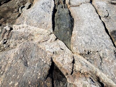
Description
Photo 4: A view toward the north of a tabular dike of very light gray intrusive igneous rock (granite) cutting across medium gray, strongly foliated, porphyritic granodiorite of the South Pond Porphyry (Dsp) that contains an elongated mass of dark gray metamorphic rock (possibly a xenolith). A generalized history of this outcrop can be summarized as follows: (1) Igneous crystallization, ~415 million years ago, of a porphyritic granodiorite magma deep underground that contained a darker colored mass (possible xenolith). (2) Deformation of these rocks in the solid state due to superimposed stress, which imparted a strong north-south alignment of the minerals within the granodiorite and the possible xenolith. (3) Later, flow of hot silica-rich fluid magma up through a crack in the rocks and then solidification in place as granite. (4) Uplift and erosion over millions of years, of miles of overlying rocks, exposing formerly deep rocks at the surface. South end of Eastern Egg Rock, Saint George.
Project Name: STATEMAP New Harbor Bedrock24k
Exact Creation Date
9-16-2022
Location
Saint George
Supplemental Rights
Credit must be given to the photographer and the Maine Geological Survey when this photo is displayed, reproduced, distributed and/or used in derivative works.
Keywords
bedrock mapping; outcrop; STATEMAP; New Harbor