


Preview
Contributing Institution
Maine Geological Survey
Document Type
Image
Identifier
70134
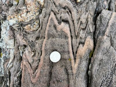
Description
Photo 14: View towards the south of a vertical outcrop surface showing tight, shallow-plunging, upright folds in garnet-rich granofels of the coticule member of the Cape Elizabeth Formation (Ocect). These folds formed during roughly east-west directed compressional deformation associated with the Devonian Acadian orogeny. The geometry of these small-scale folds mimics the much larger scale folds that control the north-south trending outcrop patterns observed on the geologic map and the fold geometry portrayed in the Interpretive Cross Section. Indian Point, Georgetown.
Project Name: STATEMAP Phippsburg Bedrock24k
Exact Creation Date
4-14-2022
Location
Georgetown
Supplemental Rights
Credit must be given to the photographer and the Maine Geological Survey when this photo is displayed, reproduced, distributed and/or used in derivative works.
Keywords
bedrock mapping; outcrop; STATEMAP