


Preview
Contributing Institution
Maine Geological Survey
Document Type
Image
Identifier
70123
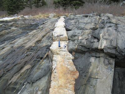
Description
Photo 3: A tabular dike of light-colored intrusive igneous rock (granite) cutting across dark-colored stratified metamorphic rocks (amphibolite). The granite dike formed when hot silica-rich fluid magma flowed up through cracks in the metamorphic rocks deep underground and then solidified in place. Bodies of granite occur throughout the quadrangle and exist as both larger mappable bodies (Dbg) and smaller tabular intrusions, such as shown above. Indian Point, Georgetown.
Project Name: STATEMAP Phippsburg Bedrock24k
Exact Creation Date
4-14-2022
Location
Georgetown
Supplemental Rights
Credit must be given to the photographer and the Maine Geological Survey when this photo is displayed, reproduced, distributed and/or used in derivative works.
Keywords
bedrock mapping; outcrop; STATEMAP