


Preview
Contributing Institution
Maine Geological Survey
Document Type
Image
Identifier
70119
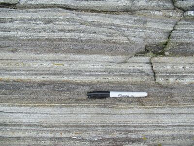
Description
Photo 13: View down on an outcrop surface of steeply dipping interlayered biotite (darker colored) and calc-silicate granofels in the Bucksport Formation (Sb) of the Kingsclear Group. These rocks represent metamorphosed fine-grained sediment of variable composition that was originally deposited in horizontal layers on the ocean floor. Folding during Devonian compressional deformation rotated these rocks into their present-day near-vertical orientation. High Ledge Lane, Boothbay Harbor.
Project Name: STATEMAP Boothbay Harbor Bedrock24k
Exact Creation Date
7-12-2021
Location
Boothbay Harbor
Supplemental Rights
Credit must be given to the photographer and the Maine Geological Survey when this photo is displayed, reproduced, distributed and/or used in derivative works.
Keywords
bedrock mapping; outcrop; STATEMAP