


Preview
Contributing Institution
Maine Geological Survey
Document Type
Image
Identifier
70105
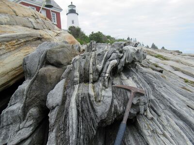
Description
Photo 13: View towards the north-northeast of tight, shallow plunging, upright folds (f2) in layered granofels of the Bucksport Formation (Sb). These second generation folds (f2) are more common than the earlier recumbent folds (f1) illustrated in Photo 12 and formed during roughly east-west directed compressional deformation associated with the Devonian Acadian orogeny. The geometry of these small-scale folds mimic the much larger scale folds that control the north-south trending outcrop patterns observed on the geologic map and displayed in cross section A-A'. Pemaquid Point, Bristol.
Project Name: STATEMAP Pemaquid Point Bedrock24k
Exact Creation Date
7-12-2021
Location
Bristol
Supplemental Rights
Credit must be given to the photographer and the Maine Geological Survey when this photo is displayed, reproduced, distributed and/or used in derivative works.
Keywords
bedrock mapping; STATEMAP; outcrop