


Preview
Contributing Institution
Maine Geological Survey
Document Type
Image
Identifier
70094
Description
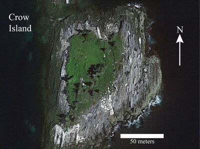
Photo 2: Google Earth view of Crow Island, South Bristol, a location not visited by either of the map authors, but a location interpreted to be underlain by interlayered biotite and calc-silicate granofels of the Bucksport Formation (Sb). The thinly spaced systematic fracturing and color banding oriented ~010° is interpreted to represent the strike of compositional layering. The dip angle or dip direction cannot be estimated from this image. Note the presence of sills (parallel to layering) and dikes (oblique to layering) of light colored granitic rock intruding the gray metamorphic rocks.
Project Name: STATEMAP Pemaquid Point Bedrock24k
Exact Creation Date
12-6-2021
Location
South Bristol
Supplemental Rights
Credit must be given to the photographer and the Maine Geological Survey when this photo is displayed, reproduced, distributed and/or used in derivative works.
Keywords
bedrock mapping; STATEMAP; outcrop