


Preview
Contributing Institution
Maine Geological Survey
Document Type
Image
Identifier
69772
Description
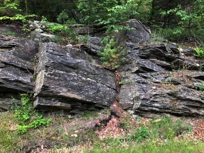
Photo 12: View towards the east of a roadcut of Bucksport Formation (Sb) illustrating multiple fracture surfaces along gentle east dipping compositional layers (dipping into the hillside), and two prominent near vertical fractures (joints) at this particular location. These planes of breakage in what are otherwise relatively impermeable crystalline rocks are important avenues of groundwater flow in the subsurface. Route 129 east of Wiley Point, South Bristol.
Project Name: STATEMAP Bristol Bedrock24k
Exact Creation Date
6-25-2021
Location
South Bristol
Supplemental Rights
Credit must be given to the photographer and the Maine Geological Survey when this photo is displayed, reproduced, distributed and/or used in derivative works.
Keywords
bedrock mapping; outcrop; STATEMAP