


Preview
Contributing Institution
Maine Geological Survey
Document Type
Image
Identifier
69761
Description
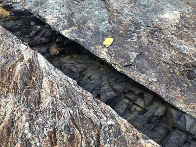
Photo 1: Dark gray, fine-grained diabase dike cutting previously deformed and metamorphosed migmatites of the Cross River Formation (O0cr). Diabase is the youngest rock type in the Bristol quadrangle (probably about 200 million years old) and formed when hot relatively silica-poor fluid magma flowed rapidly up through cracks in the surrounding older rocks and then solidified. The locations of these dikes are shown on the map with red symbols. Thurston Point, north side of Pemaquid Harbor, Bristol. Yellow field notebook for scale.
Project Name: STATEMAP Bristol Bedrock24k
Exact Creation Date
7-13-2021
Location
Bristol
Supplemental Rights
Credit must be given to the photographer and the Maine Geological Survey when this photo is displayed, reproduced, distributed and/or used in derivative works.
Keywords
bedrock mapping; outcrop; STATEMAP