

Preview
Document Type
StillImage
Contributing Institution
Maine State Archives
Identifier
211714
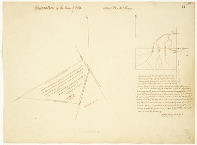
Description
Map 1: "This lot contains 320 acres of land, and is the lot which was reserved for the future disposition of the Government, in the Town of Porter, by the committee for the sale of Eastern lands, in their deed of said Town to Jeremiah Hill & others. Scale of 40 rods to one inch."
Map 2: "This plan represents the north half of Township No. 1 in the third range of Townships adjoining Bingham's Kennebec purchase." Scale of one mile to one inch.
Exact Creation Date
1819
Language
English
Location
Oxford County; Porter; Franklin County; Coplin Plt
Other Location
Dead River; Black Stream; Mount Bigelow
Keywords
Cartography; Maps; Maine Land Office; Planbooks; Surveys
Image Location
Rights Statement
No Copyright - United States. URI: http://rightsstatements.org/vocab/NoC-US/1.0/
The organization that has made the Item available believes that the Item is in the Public Domain under the laws of the United States, but a determination was not made as to its copyright status under the copyright laws of other countries. The Item may not be in the Public Domain under the laws of other countries. Please refer to the organization that has made the Item available for more information.