

Preview
Document Type
StillImage
Contributing Institution
Maine State Archives
Identifier
211714
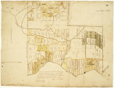
Description
"The outlines of the plan represent the Township number one, on the east side of Penobscot River as the same was surveyed by the order of Salem Town Esq. in the year 1797, and the survey of the shore of Penobscot River and alotment thereof by James Irish and Andrew Strong Esq. in the year 1818 under the direction of Lothrop Lewis, Survey'r Gen'l. Protracted by a scale of 100 rods to one inch."
Broad Creation Date
1797-1818
Language
English
Location
Penobscot County; Lowell; Passadumkeag
Keywords
Cartography; Maps; Maine Land Office; Planbooks; Surveys
Rights Statement
No Copyright - United States. URI: http://rightsstatements.org/vocab/NoC-US/1.0/
The organization that has made the Item available believes that the Item is in the Public Domain under the laws of the United States, but a determination was not made as to its copyright status under the copyright laws of other countries. The Item may not be in the Public Domain under the laws of other countries. Please refer to the organization that has made the Item available for more information.