


Preview
Contributing Institution
Maine Geological Survey
Document Type
Image
Identifier
9714
Description
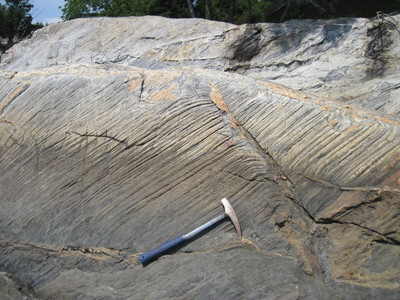
Photo 9: View towards the northwest looking at a southeast-dipping foliation surface of mylonitic gneisses of the Cushing Formation (Oc). Note the prominent southwest-plunging quartz rod lineations (oriented parallel to the hammer handle). Shoreline exposure approximately 2500 feet northeast of Flying Point, Freeport.
Project Name: Bedrock Geology 24k Freeport
Exact Creation Date
6-30-2017
Location
Freeport
Supplemental Rights
Credit must be given to the photographer and the Maine Geological Survey when this photo is displayed, reproduced, distributed and/or used in derivative works.
Keywords
bedrock mapping; outcrop; STATEMAP; Freeport