


Preview
Contributing Institution
Maine Geological Survey
Document Type
Image
Identifier
9713
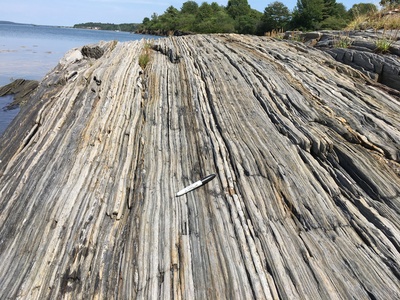
Description
Photo 8: View towards the north of nearly vertically dipping layers of light gray impure quartzite and darker gray mica-rich phyllite in the Cape Elizabeth Formation (Ocep). These rocks represent metamorphosed fine-grained sand and mud that was originally deposited in horizontal layers on the ocean floor in Ordovician time. Folding during Devonian compressional deformation flipped these rocks into their present-day near-vertical orientation. Shoreline exposure approximately 1000 feet west of Curtis Cove, Harpswell.
Project Name: Bedrock Geology 24k Freeport
Exact Creation Date
8-10-2017
Location
Harpswell
Supplemental Rights
Credit must be given to the photographer and the Maine Geological Survey when this photo is displayed, reproduced, distributed and/or used in derivative works.
Keywords
bedrock mapping; outcrop; STATEMAP; Freeport