


Preview
Contributing Institution
Maine Geological Survey
Document Type
Image
Identifier
9707
Description
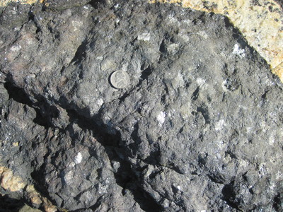
Photo 2: Dark gray, very coarse-grained amphibolite in the Nehumkeag Pond Formation (Onpa). The rock is composed primarily of the mineral hornblende and light can be seen reflecting off cleavage surfaces in this mineral. These rocks are interpreted to represent metamorphosed mafic igneous rocks. The light-colored rock in the upper right corner of the photo is a younger cross-cutting pegmatite dike of granitic composition. Shoreline exposure approximately 2000 feet southwest of Brewers Point in South Freeport.
Project Name: Bedrock Geology 24k Freeport
Exact Creation Date
6-28-2017
Location
Freeport
Supplemental Rights
Credit must be given to the photographer and the Maine Geological Survey when this photo is displayed, reproduced, distributed and/or used in derivative works.
Keywords
bedrock mapping; outcrop; STATEMAP; Freeport