


Preview
Contributing Institution
Maine Geological Survey
Document Type
Image
Identifier
72151
Description
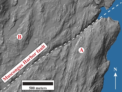
Figure 1: Lidar (Light Detection and Ranging) image of the Muscongus Harbor area that provides a high-resolution model of the Earth’s surface (topography). The imagery shows a prominent topographic lineament oriented ~050° that is interpreted to represent a post-metamorphic high-angle brittle fault, here referred to as the Muscongus Harbor fault. The presence of unlithified fault gouge located along the trace of the lineament is strong supporting evidence for the brittle fault hypothesis. Two additional similarly oriented topographic lineaments in the quadrangle are also interpreted to be brittle faults. The Coombs Cove fault, first recognized in the Bristol quadrangle to the west (West and Hussey, 2022), projects through Round Pond. The Browns Cove fault is located in the southern portion of the quadrangle. The Mesozoic Moxie Cove diabase dike (J2mc) appears to be cut by both the Coombs Cove and Louds Island faults, supporting the interpretation of post-metamorphic displacement. The lidar image also shows differences in the topographic expression of stratified versus intrusive igneous rocks in areas of the quadrangle where there is thin unconsolidated sediment cover. In the area marked “A,” a series of low narrow ridges oriented ~020° are parallel to the strike of steeply dipping granofels of the Bucksport Formation (Sb). Just north of the “A,” one can see what appears to be the nose of a tight, plunging fold structure (see Photo 8 for a small-scale example). In contrast, the area marked “B” is primarily underlain by unlayered granitic rocks (Dbg) and does not exhibit narrow ridges. In this area, short topographic lineaments likely reflect a preferred fracture orientation within the granitic rocks.
Project Name: STATEMAP Louds Island Bedrock24k
Exact Creation Date
1-21-2023
Supplemental Rights
Credit must be given to the photographer and the Maine Geological Survey when this photo is displayed, reproduced, distributed and/or used in derivative works.
Keywords
bedrock mapping; outcrop; STATEMAP; Louds Island