


Preview
Contributing Institution
Maine Geological Survey
Document Type
Image
Identifier
72138
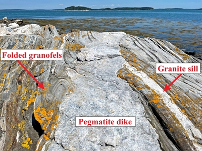
Description
Photo 2: View towards the northeast, parallel to the strike of a pegmatite dike. Pegmatite is a very coarse grained variety of granite and is ubiquitous in the quadrangle, occurring primarily as meter- to sub-meter-wide tabular dikes and sills in surrounding rocks. Note how this dike cuts layers in granofels of the Bucksport Formation (Sb), the limb of a small-scale fold in these stratified rocks, and a thin granite sill. These cross-cutting relationships indicate the intrusion of the pegmatite dike occurred after the intrusion of the thin granite sill and after the folding of the granofels. Harbor Island, Friendship.
Project Name: STATEMAP Louds Island Bedrock24k
Exact Creation Date
1-20-2023
Location
Friendship
Supplemental Rights
Credit must be given to the photographer and the Maine Geological Survey when this photo is displayed, reproduced, distributed and/or used in derivative works.
Keywords
bedrock mapping; outcrop; STATEMAP; Louds Island