


Preview
Contributing Institution
Maine Geological Survey
Document Type
Image
Identifier
70503
Description
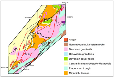
Figure 31. Proposed correlation of Miramichi faults in Maine and New Brunswick. Black lines indicate previously mapped faults. Red lines indicate proposed connections. Plutons and faults as in Figure 1, plus: BBF-Bamford Brook; MF-Meductic; WF-Woodstock.
Project Name: Bedrock Geology 24k Greenfield
Supplemental Rights
Credit must be given to the photographer and the Maine Geological Survey when this photo is displayed, reproduced, distributed and/or used in derivative works.
Keywords
bedrock mapping; Greenfield quadrangle