


Preview
Contributing Institution
Maine Geological Survey
Document Type
Image
Identifier
70502
Description
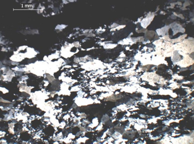
Figure 30 (continued). Southeast Boundary fault in the Greenfield quadrangle. C-D (east-central part of quadrangle just west of Cross Road) C: Cataclasite with fragments of Miramichi (Greenfield member?) and County Road rocks and brecciated vein quartz. D: Photomicrograph (X) showing polygonalization of vein quartz.
Project Name: Bedrock Geology 24k Greenfield
Location
Greenfield Twp
Supplemental Rights
Credit must be given to the photographer and the Maine Geological Survey when this photo is displayed, reproduced, distributed and/or used in derivative works.
Keywords
bedrock mapping; Greenfield quadrangle