


Preview
Contributing Institution
Maine Geological Survey
Document Type
Image
Identifier
70107
Description
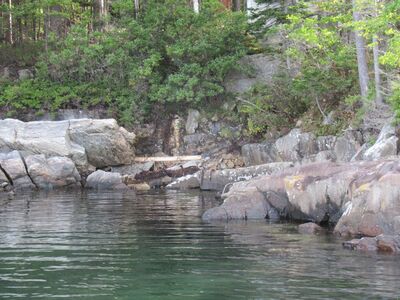
Photo 1: View towards the east of the northern contact of the Christmas Cove diabase dike (J2cc, darker colored rocks on the right) with the Cape Elizabeth Formation (Oce). At this location, the dike is about 50 feet wide and strikes approximately 085°. Diabase represents the youngest rock type in the quadrangle (~200 million years old) and formed when hot silica-poor magma flowed rapidly through cracks in the surrounding older rocks and then solidified. This particular dike, the largest in the region (McHone and others, 2014), can be traced across the quadrangle. The locations of numerous additional smaller dikes are shown on the map with red symbols. Deep Cove, Southport Island.
Project Name: STATEMAP Boothbay Harbor Bedrock24k
Exact Creation Date
10-5-2021
Location
Southport
Supplemental Rights
Credit must be given to the photographer and the Maine Geological Survey when this photo is displayed, reproduced, distributed and/or used in derivative works.
Keywords
bedrock mapping; outcrop; STATEMAP