


Preview
Contributing Institution
Maine Geological Survey
Document Type
Image
Identifier
70101
Description
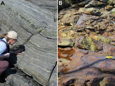
Photo 9: Photos of two different rock types exposed on Outer Heron Island that are not found on the mainland. Because of uncertainties correlating with specific formations, these rocks are assigned to unnamed units of the Casco Bay Group. Photo A shows hornblende gneiss (Ocba) with abundant diopside-rich (green) interlayers. Photo B shows fine-grained, deeply rusty weathering, sulfide- and graphite-rich schist (Ocbu). Outer Heron Island, Boothbay.
Project Name: STATEMAP Pemaquid Point Bedrock24k
Exact Creation Date
11-27-2021
Location
Boothbay
Supplemental Rights
Credit must be given to the photographer and the Maine Geological Survey when this photo is displayed, reproduced, distributed and/or used in derivative works.
Keywords
bedrock mapping; STATEMAP; outcrop