


Preview
Contributing Institution
Maine Geological Survey
Document Type
Image
Identifier
69769
Description
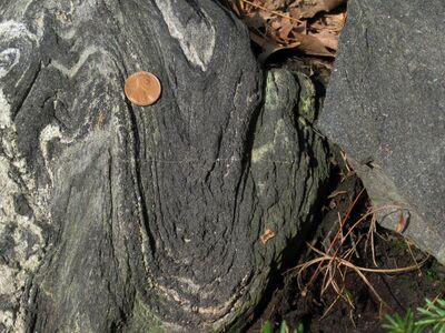
Photo 9: Folded layers of dark gray hornblende-rich gneiss of the amphibolite member of the Cape Elizabeth Formation (Ocea). These rocks are interpreted to represent metamorphosed mafic (basaltic) igneous rocks within the metasedimentary-dominated Cape Elizabeth Formation (Oce). The tight folds formed during relatively high-temperature compressional deformation associated with the Devonian Acadian orogeny. Back Narrows Road, Boothbay.
Project Name: STATEMAP Bristol Bedrock24k
Exact Creation Date
9-12-2021
Location
Boothbay
Supplemental Rights
Credit must be given to the photographer and the Maine Geological Survey when this photo is displayed, reproduced, distributed and/or used in derivative works.
Keywords
bedrock mapping; outcrop; STATEMAP