


Preview
Contributing Institution
Maine Geological Survey
Document Type
Image
Identifier
67558
Description
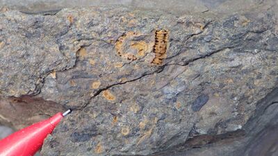
Photo 2: Phytodebris (dark) and fragments of crinoids and gastropods in restricted coastal/estuarine (lagoonal?) setting in a borrow pit near Rocky Brook Road. St. Froid Lake Formation (Dsf).
Project Name: STATEMAP Carr Pond Bedrock24k
Exact Creation Date
8-15-2021
Supplemental Rights
Credit must be given to the photographer and the Maine Geological Survey when this photo is displayed, reproduced, distributed and/or used in derivative works.
Keywords
bedrock mapping; outcrop; STATEMAP; Carr Pond