


Preview
Contributing Institution
Maine Geological Survey
Document Type
Image
Identifier
67287
Description
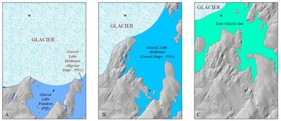
Illustrations of possible proglacial lake and late-glacial sea extents in the Unity quadrangle as ice retreated to the northwest. Meltwater paths/spillways marked with blue arrows. Unity and Freedom village locations marked with U and F for reference. A: Extents of Glacial Lake Freedom and Glacial Lake Halfmoon (highest stage). B: Extent of Glacial Lake Halfmoon (lowest stage). C: Extent of late-glacial sea, which entered from low area in northwest portion of the quadrangle.
Project Name: STATEMAP Unity Surficial
Exact Creation Date
3-10-2022
Supplemental Rights
Credit must be given to the photographer and the Maine Geological Survey when this photo is displayed, reproduced, distributed and/or used in derivative works.
Keywords
STATEMAP; Unity quadrangle; surficial geology