


Preview
Contributing Institution
Maine Geological Survey
Document Type
Image
Identifier
10376
Description
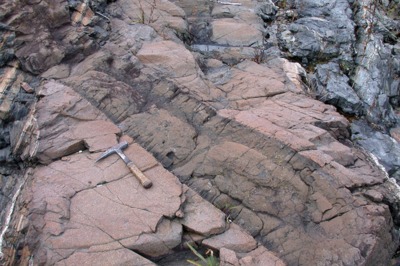
Photo 16: A 2-meter-thick, brown-weathering diabase dike cutting the Kittery Formation, in turn cut by a thinner basalt dike. Shoreline north of Bald Head Cliff, York, Maine.
Project Name: Bedrock Geology 100k Kittery
Location
York
Supplemental Rights
Credit must be given to Maine Geological Survey and the photographer when this photo is displayed, reproduced, distributed and/or used in derivative works.
Keywords
bedrock mapping; outcrop; STATEMAP