

Preview
Contributing Institution
Maine State Archives
Document Type
Image
Identifier
4-324254-I008
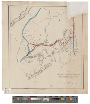
Description
Sketch of the Imaginary Ranges of Highlands Reported by the British Surveyors Under the Treaty of Ghent, As Extending Across the State of Maine, Plate 3. Part of Bouchette's Maps of Upper & Lower Canada and of the District of Gaspe exhibiting the true range of highlands dividing the waters of the St. Lawrence and the Atlantic, and the Imaginary Ranges claimed by the British for the boundary of the State of Maine. Plate II (4 copies). Published by Shirley & Hyde, 1829.
See also http://www.davidrumsey.com/maps880036-24204.html
Exact Creation Date
1829
Language
English; French
Location
Aroostook County; Houlton; Mars Hill
Other Location
St. Lawrence River; Monument Line; Penobscot River; Chaudiere River; Mount Katahdin; Chesuncook Lake; Allagash River; Dead River; Kennebec River; Bald Mountain; Moose River; Mattawamkeag River
Keywords
Cartography; Maps; Surveys