

Preview
Document Type
StillImage
Contributing Institution
Prince Memorial Library
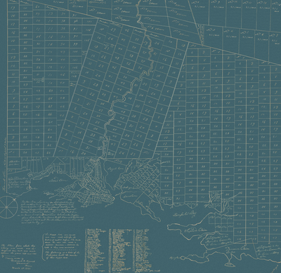
Description
On March 3, 1883, Ferdinand B. Merrill of Yarmouth, a civil engineer who served on the Yarmouth Board of Selectmen in 1885, 1899 and 1890, made a tracing of a plan “drawn by a scale of One hundred rods to an inch and is a description of the Town of North Yarmouth as formerly laid out by the Proprietors of said Town.” On his tracing, Merrill wrote: “The plan from which this tracing was made was the original one and was made between the years 1681 and 1735 by [blank]”
Exact Creation Date
3-3-1883
Dimensions
83 cm x 80 cm
Language
English
Location
Cumberland County; North Yarmouth
Keywords
North Yarmouth; Maine; Maps; Proprietors Maps; Plans
Image Location
Rights Statement
No Copyright - United States. URI: http://rightsstatements.org/vocab/NoC-US/1.0/
The organization that has made the Item available believes that the Item is in the Public Domain under the laws of the United States, but a determination was not made as to its copyright status under the copyright laws of other countries. The Item may not be in the Public Domain under the laws of other countries. Please refer to the organization that has made the Item available for more information.