

Preview
Contributing Institution
Maine State Archives
Document Type
StillImage
Identifier
302963
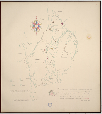
Description
Page 6 of the Sagadahoc County planbook. Copied from the Massachusetts Archives Maps and Plans #1359. Scale of 800 rods to 2.5 miles.
"Agreeably to a law of the Commonwealth of Massachusetts pass'd the 26th June A.D. 1794 requiring each town to have an accurate plan taken thereof and lodg'd in the Secretary's Office by the first day of June A.D. 1795. Accordingly having been appointed by the Selectmen for the above purpose, have taken an actual Survey of the town of Georgetown in the Month of October last."
Exact Creation Date
5-25-1795
Language
English
Location
Sagadahoc County; Georgetown
Keywords
Cartography; Maps; Maine Land Office; Planbooks; Surveys
Image Location
Rights Statement
No Copyright - United States. URI: http://rightsstatements.org/vocab/NoC-US/1.0/
The organization that has made the Item available believes that the Item is in the Public Domain under the laws of the United States, but a determination was not made as to its copyright status under the copyright laws of other countries. The Item may not be in the Public Domain under the laws of other countries. Please refer to the organization that has made the Item available for more information.