

Preview
Contributing Institution
Maine State Archives
Document Type
StillImage
Identifier
302962
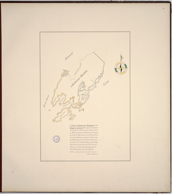
Description
Page 8 of Knox County planbook. Copied from Massachusetts Archives Maps & Plans #1366.
"A Plan of Madumcook Plantation in the County of Lincoln taken by James Malcom agreeably to a Resolve of the General Court of Massachusetts for the Purpose of Surveying the Towns & Plantations in the Same, the centre of Said Plantation being 210 Miles from the Metropolis of the Commonwealth and 40 miles from the Shire Town of the County. Said Survey being taken Dec. 28, 1795 at the Request of a Committee appointed by the Said Plantation for the Said Purpose. The Plan is Drawn by a Scale of 200 Rods to an inch."
Survey of Meduncook Plantation, Friendship, Cushing, Broad Sound, Waldoboro, Long Island, Bradfords Roads, Crotch Island, Gaunt Neck, Hatchet Cove, and Davises Island.
Exact Creation Date
12-28-1795
Language
English
Location
Knox County; Friendship; Lincoln County
Keywords
Cartography; Maps; Maine Land Office; Planbooks; Surveys
Rights Statement
No Copyright - United States. URI: http://rightsstatements.org/vocab/NoC-US/1.0/
The organization that has made the Item available believes that the Item is in the Public Domain under the laws of the United States, but a determination was not made as to its copyright status under the copyright laws of other countries. The Item may not be in the Public Domain under the laws of other countries. Please refer to the organization that has made the Item available for more information.