

Preview
Contributing Institution
Maine State Archives
Document Type
StillImage
Identifier
302962
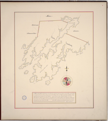
Description
Page 6 of the Knox County planbook. Copied from Massachusetts Archives Maps and Plans #1353.
"A plan of the Town of Cushing in the County of Lincoln taken by order of said Town agreeably to an act of the General Court passed June 26, 1794 for the said Purpose by James Malcom, being appointed by said Town for that Purpose. Said Survey being completed April 16, 1795. The Reported Distance of the Centre of said Town from the Shire Town of the County is thirty five miles and from the Metropiolous of the Commonwealth two hundred and seven miles and the boundaries of said Town as per Plan. Said Plan is Drawn by a Scale of 20 rods to an inch."
Includes Long Cove, Cutlers Cove, Broad Cove, St. George's River, saw and grist mills, Smiths Island, the Narrows, Warren, St. George's Bay, Wattson's Point, Old Fort Point, Gaunt Neck Cove, Meduncook River, Pleasant Point, Maple Juice Cove, Turks Cove, Gays Island, Caldwells Island, Herring Gut, and Mosehetto Harbor [Mosquito Harbor].
Exact Creation Date
4-16-1795
Language
English
Location
Knox County; Cushing
Keywords
Cartography; Maps; Maine Land Office; Planbooks; Surveys
Image Location
Rights Statement
No Copyright - United States. URI: http://rightsstatements.org/vocab/NoC-US/1.0/
The organization that has made the Item available believes that the Item is in the Public Domain under the laws of the United States, but a determination was not made as to its copyright status under the copyright laws of other countries. The Item may not be in the Public Domain under the laws of other countries. Please refer to the organization that has made the Item available for more information.