

Preview
Document Type
StillImage
Contributing Institution
Maine State Archives
Identifier
211714
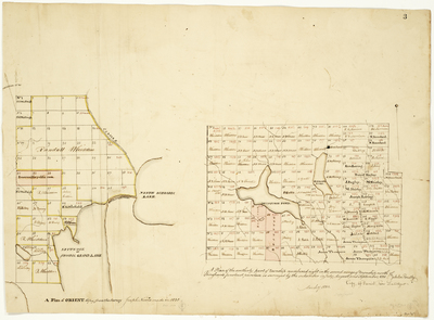
Description
A plan of Orient copied from the survey Joseph Norris made in 1828;
A Plan of the southerly part of township numbered eight in the second range of townships north of Bingham's Penobscot purchase, 1831
Broad Creation Date
1828-1831
Language
English
Location
Washington County; Topsfield; Aroostook County; Orient
Other Location
Schoodic Lake; Spitnook; Schoodic Grand Lake; St. Croix River; Musquash Pond; Pleasant Pond
Keywords
Cartography; Maps; Maine Land Office; Planbooks; Surveys
Image Location
Rights Statement
No Copyright - United States. URI: http://rightsstatements.org/vocab/NoC-US/1.0/
The organization that has made the Item available believes that the Item is in the Public Domain under the laws of the United States, but a determination was not made as to its copyright status under the copyright laws of other countries. The Item may not be in the Public Domain under the laws of other countries. Please refer to the organization that has made the Item available for more information.