

Preview
Document Type
StillImage
Contributing Institution
Maine State Archives
Identifier
208369
Description
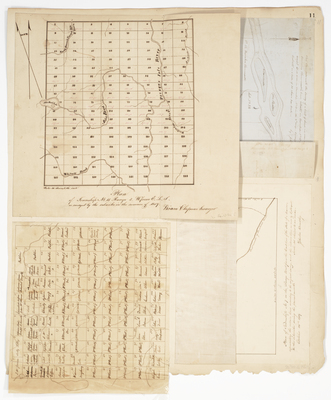
Plans of Township 11 Range 3 WELS, Township 7 Range 10 WELS, St Francis, and township survey with owner names
Broad Creation Date
1839-1859
Language
English
Location
Aroostook County; Saint Francis
Map-Land Office-Plan book 3A. p.11b, 1) T7R10 WELS, Zebulon Bradley surveyor, 1839 2) St. Francis 2, 110 acres 3) T11R3 WELS, Hiram Chapman surveyor, 1859 4) township showing names of owners-208370.jpg (59094 kB)
Supplement 1
Map-Land Office-Plan book 3A. p.11a, 1) T7R10 WELS, Zebulon Bradley surveyor, 1839 2) St. Francis 2, 110 acres 3) T11R3 WELS, Hiram Chapman surveyor, 1859 4) township showing names of owners-208370.jpg (57711 kB)
Supplement 2
Supplement 1
Map-Land Office-Plan book 3A. p.11a, 1) T7R10 WELS, Zebulon Bradley surveyor, 1839 2) St. Francis 2, 110 acres 3) T11R3 WELS, Hiram Chapman surveyor, 1859 4) township showing names of owners-208370.jpg (57711 kB)
Supplement 2
Keywords
Cartography; Maps; Maine Land Office; Planbooks; Surveys