

Preview
Document Type
StillImage
Contributing Institution
Maine State Archives
Identifier
208369
Description
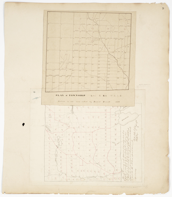
Plan of Township Letter E Range 1 WELS.
Plan of the survey and allotment of Township No. 5 R3 WELS (now Oakfield) on a scale of 40 chains to an inch.
Exact Creation Date
1859
Language
English
Location
Aroostook County; E Twp; Oakfield
Other Location
Long Lake; Spaulding Lake; Mattawamkeag River; Skitticook Lake
Keywords
Cartography; Maps; Maine Land Office; Planbooks; Surveys