

Preview
Contributing Institution
Maine State Archives
Document Type
StillImage
Identifier
29457
Description
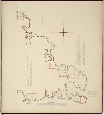
This map is the first part of the 1794 survey of Addison in Washington County. Second part of survey bound in plan book as page 1. Copied from Massachusetts Archives Maps and Plans #1431 Vol 48 Page 7 and #1014 Vol 48 Page 8.
"Note: The original plan being too large to be duplicated on a sheet of this size is here divided on an imaginary East and West line ("A to B") show in green - part No. 1 being the south half. J.H. Cochrane, Copyist"
Exact Creation Date
1794
Language
English
Location
Washington County; Addison
Other Location
Marsh Harbour; Poates Harbour; Eastern Harbour
Keywords
Cartography; Maps; Maine Land Office; Planbooks; Surveys
Image Location
Rights Statement
No Copyright - United States. URI: http://rightsstatements.org/vocab/NoC-US/1.0/
The organization that has made the Item available believes that the Item is in the Public Domain under the laws of the United States, but a determination was not made as to its copyright status under the copyright laws of other countries. The Item may not be in the Public Domain under the laws of other countries. Please refer to the organization that has made the Item available for more information.