


Files
Download Map (3.7 MB)
Document Type
StillImage
Description
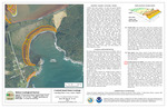
Maine Geological Survey, Open-File Map 26-161
Publication Code
26-161
Publication Date
3-4-2026
Publisher
Maine Geological Survey
Supercedes
Location
Washington County
Map Type
Coastal Sand Dune Geology Maps (scale 1:4,800)
Map Scale
1:4800
Recommended Citation
Slovinsky, Peter A., and Dickson, Stephen M., 2026, Coastal sand dune geology: Carrying Place Cove, Lubec, Maine: Maine Geological Survey, Open-File Map 26-161, aerial photo, scale 1:4,800. Maine Geological Survey Maps. 3046. https://digitalmaine.com/mgs_maps/3046
Rights Statement

No Copyright - United States. URI: http://rightsstatements.org/vocab/NoC-US/1.0/
The organization that has made the Item available believes that the Item is in the Public Domain under the laws of the United States, but a determination was not made as to its copyright status under the copyright laws of other countries. The Item may not be in the Public Domain under the laws of other countries. Please refer to the organization that has made the Item available for more information.