


Files
Download Map (4.9 MB)
Document Type
StillImage
Description
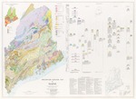
Maine Geological Survey (Department of Economic Development) (Superseded by Osberg, Philip H., Hussey, Arthur M., II, and Boone, Gary M., 1984, Open-File No. 84-1). A 42" x 58" color wall map showing the bedrock geology of Maine. Ages of rocks in color, lithologies differentiated by patterns, inset map of metamorphic zones, correlation chart and extensive reference list.
Publication Code
PBGMM
Publication Date
1-1-1967
Publisher
Maine Geological Survey
Superceded by
84-1
Location
Androscoggin County; Aroostook County; Cumberland County; Franklin County; Hancock County; Kennebec County; Knox County; Lincoln County; Oxford County; Penobscot County; Piscataquis County; Sagadahoc County; Somerset County; Waldo County; Washington County; York County
Map Type
Bedrock Geology Maps (regional); Geologic Maps of the State of Maine
Map Scale
1:500000
Recommended Citation
Hussey, Arthur M., II (chief compiler), Chapman, Carleton A., Doyle, Robert G., Hussey, Arthur M., II, Osberg, Philip H., Pavlides, Louis, and Warner, Jeffrey (area compilers), 1967, Preliminary geologic map of Maine: Maine Geological Survey (Department of Economic Development) (Superseded by Osberg, Philip H., Hussey, Arthur M., II, and Boone, Gary M., 1984, Open-File No. 84-1), 1 plate, scale 1:500,000. Maine Geological Survey Maps. 22. http://digitalmaine.com/mgs_maps/22
Rights Statement

No Copyright - United States. URI: http://rightsstatements.org/vocab/NoC-US/1.0/
The organization that has made the Item available believes that the Item is in the Public Domain under the laws of the United States, but a determination was not made as to its copyright status under the copyright laws of other countries. The Item may not be in the Public Domain under the laws of other countries. Please refer to the organization that has made the Item available for more information.