


Files
Download Map (33.6 MB)
Document Type
StillImage
Description
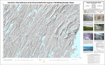
Maine Geological Survey, Open-File Map 09-42.
Publication Code
09-42
Publication Date
1-1-2009
Publisher
Maine Geological Survey
Location
Androscoggin County; Kennebec County; Knox County; Lincoln County; Sagadahoc County; Waldo County
Map Type
Surficial Geology Maps (scale 1:100,000)
Map Scale
1:100000
Recommended Citation
Tolman, Susan S. (compiler), 2009, Glacial ice-flow indicators in the western half of the Augusta 1:100,000 quadrangle, Maine: Maine Geological Survey, Open-File Map 09-42, map, scale 1:100,000. Maine Geological Survey Maps. 1833. http://digitalmaine.com/mgs_maps/1833
Rights Statement

No Copyright - United States. URI: http://rightsstatements.org/vocab/NoC-US/1.0/
The organization that has made the Item available believes that the Item is in the Public Domain under the laws of the United States, but a determination was not made as to its copyright status under the copyright laws of other countries. The Item may not be in the Public Domain under the laws of other countries. Please refer to the organization that has made the Item available for more information.