


Files
Download Map (4.0 MB)
Document Type
StillImage
Description
Maine Geological Survey, Open-File Map 01-167
Publication Code
01-167
Publication Date
1-1-2001
Publisher
Maine Geological Survey
Related Item
Daniel B. Locke, Craig B. Neil, William J. Nichols Jr, and Thomas K. Weddle, Hydrogeology and water quality of significant sand and gravel aquifers in parts of Aroostook, Penobscot, and Washington Counties, Maine
Supercedes
97-15
Location
Aroostook County
Map Type
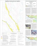
Significant Sand and Gravel Aquifer Maps (scale 1:24,000)
Map Scale
1:24000
Recommended Citation
Neil, Craig D. and Locke, Daniel B. (compilers), Locke, Daniel B. (mapper), 2001, Significant sand and gravel aquifers in the Monument Brook quadrangle, Maine: Maine Geological Survey, Open-File Map 01-167, map, scale 1:24,000. Maine Geological Survey Maps. 1651. http://digitalmaine.com/mgs_maps/1651
Rights Statement

No Copyright - United States. URI: http://rightsstatements.org/vocab/NoC-US/1.0/
The organization that has made the Item available believes that the Item is in the Public Domain under the laws of the United States, but a determination was not made as to its copyright status under the copyright laws of other countries. The Item may not be in the Public Domain under the laws of other countries. Please refer to the organization that has made the Item available for more information.